- Sayama, Saitama
Japanese city
Name = Sayama
JapaneseName=狭山市
Prefecture=Saitama
Region=Kantō
Area_km2=49.04
Population=160,917
PopDate=2003
Density_km2=3281
Coords=
LatitudeDegrees= 35
LatitudeMinutes= 51
LatitudeSeconds=
LongtitudeDegrees= 139
LongtitudeMinutes= 25
LongtitudeSeconds=
Postal code=
Area code=
Mayor =
Tree =Camellia sinensis
Flower =Azalea
Bird =Azure-winged Magpie
Symbol !border| SymbolDescription= Flag
CityHallPostalCode =
CityHallAddress=
CityHallPhone=
CityHallLink = [http://www.city.sayama.saitama.jp/ Sayama] | City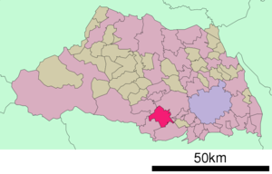
Elevation=nihongo|Sayama|狭山市|Sayama-shi, formerly known as Irumagawa, is a city located in Saitama,
Japan .As of 2003, the city has an estimated
population of 160,917 and the density of 3,281.34 persons per km². The total area is 49.04 km².The city was founded on
July 1 ,1954 .It is also the location of the assembly plant for many Honda/Acura products such as the Accord,TSX, and Acura Integra.
The current Mayor is Yukinari Nakagawa(仲川幸成) elected in 2003.
Geography
The total area is 49.04 km².
Sayama is bordered by Kawagoe, Tokorozawa, Iruma, Hannō, and Hidaka.
The Iruma River flows through the city.
Ken-Ō Expressway ,Route 16,Route 299 and Route 407 pass through Sayama.Notable persons from Sayama
*
Matsushige Ohno (大野松茂), politicianOther uses
Sayama was the name of a town in the
Osaka Prefecture of Japan before it was reorganized into the city of Osakasayama.ister cities
*flagicon|United States -
Worthington, Ohio
*flagicon|China -Hangzhou External links
* [http://www.city.sayama.saitama.jp/ Sayama official website] in Japanese

Wikimedia Foundation. 2010.