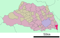
- Misato, Saitama (city)
-
Misato
三郷市— City — [[File:|border|100px|border|alt=|Flag of Misato]]
FlagLocation of Misato in Saitama Coordinates: 35°50′N 139°52′E / 35.833°N 139.867°ECoordinates: 35°50′N 139°52′E / 35.833°N 139.867°E Country Japan Region Kantō Prefecture Saitama Government – Mayor Masaaki Kizu (since November 2006) Area – Total 30.16 km2 (11.6 sq mi) Population (January 1, 2011) – Total 132,937 – Density 4,407.73/km2 (11,416/sq mi) Time zone Japan Standard Time (UTC+9) City symbols - Tree Castanopsis - Flower Rhododendron - Bird Tachybaptus ruficollis Phone number 048-953-1111 Address 648-1 Hanawada
341-8501Website Misato Misato (三郷市 Misato-shi) is a city located in Saitama Prefecture, Japan. It borders Chiba Prefecture.
In January 2011, the city has an estimated population of 132,937 and a population density of 4,407.73 persons per km2. The total area is 30.16 km2.
The city was founded on May 3, 1972. The city has four high schools (Misato North High School, Misato Technical High School, Misato High School, and a special needs school) and numerous junior high schools and elementary schools.
External links
- Misato official website (English)
- Misato official website (Japanese)
 Saitama Prefecture
Saitama (capital city) 
Cities - Ageo
- Asaka
- Chichibu
- Fujimi
- Fujimino
- Fukaya
- Gyōda
- Hannō
- Hanyū
- Hasuda
- Hidaka
- Higashi-Matsuyama
- Honjō
- Iruma
- Kasukabe
- Kawagoe
- Kawaguchi
- Kazo
- Kitamoto
- Koshigaya
- Kōnosu
- Kuki
- Kumagaya
- Misato
- Niiza
- Okegawa
- Saitama (capital)
- Sakado
- Satte
- Sayama
- Shiki
- Sōka
- Toda
- Tokorozawa
- Tsurugashima
- Wakō
- Warabi
- Yashio
- Yoshikawa
Districts Former districts See also: Towns and villages by districtCategories:- Cities in Saitama Prefecture
- Saitama geography stubs
Wikimedia Foundation. 2010.


