- Warabi, Saitama
Japanese city
Name = Warabi
JapaneseName=蕨市
Prefecture=Saitama
Region=Kantō
Area_km2=5.10
Population=70,095
PopDate=2007
Density_km2=
Coords=
LatitudeDegrees= 35
LatitudeMinutes= 50
LatitudeSeconds=
LongtitudeDegrees= 139
LongtitudeMinutes= 41
LongtitudeSeconds=
Postal code=
Area code=
Mayor =Hideo Yoritaka
Tree =Zelkova serrata
Flower =Rhododendron indicum
Bird =
Symbol !border| SymbolDescription= Flag
CityHallPostalCode =
CityHallAddress=
CityHallPhone=
CityHallLink = [http://www.city.warabi.saitama.jp/ Warabi] | City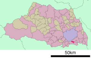
Elevation=nihongo|Warabi|蕨市|Warabi-shi is a city located in Saitama,
Japan . Warabi is the name of abracken . The city was founded onApril 1 ,1959 .As of
2003 , the city has an estimatedpopulation of 71,034 and a density of 13,928.24 persons per km². The total area is 5.10 km². Warabi is famous for being the most densely populated area of Japan.The city is served by
Warabi Station on theKeihin-Tohoku Line .Politics and Government
The directly-elected executive mayor is
Hideo Yoritaka , a member of theJapanese Communist Party . The legislative city assembly has 18 elected members.Elections
*
Warabi mayoral election, 2007
*Warabi city assembly election, 2007 Transportation
The city is served by the JR
Keihin-Tohoku Line and the main station isWarabi Station .Warabi Schools
There are a total of seven elementary schools in Warabi city:
*Warabi Chūō Elementary 蕨市立中央小学校 (Central Elementary)
*Warabi Chūō-Higashi Elementary 蕨市立中央東小学校 (Central-East Elementary)
*Warabi Nishi Elementary 蕨市立西小学校 (West Elementary)
*Warabi Higashi Elementary 蕨市立東小学校 (East Elementary)
*Warabi Tsukagoshi Elementary 塚越市立小学校 (Tsukagoshi Elementary)
*Warabi Kita Elementary 蕨市立北小学校 (North Elementary)
*Warabi Minami Elementary 蕨市立南小学校 (South Elementary):Warabi Kita Elementary was refurbished in 2004 with a new wing added and various features added to improve disabled access (automated lifts, minimal steps, slopes for wheelchair access).These Elementary schools feed a total of three Junior High Schools:
*Warabi City the First Junior High School (蕨市立第一中学校)
*Warabi City the Second Junior High School (蕨市立第二中学校)
*Warabi East Junior High (蕨市立東中学校)There are also two High Schools in Warabi City:
*Warabi High School (蕨高等学校)
*Bunan High School (武南高等学校)Notes of Interest
Warabi city has played host to the all-Japan Chinese Wushu championships, and so is one of the few Japanese cities that have a strong Wushu tradition. Wushu is offered in some elementary schools as an after-school activity, and is practised by a significant number of Elementary, Junior High, and High School Students.
External links
* [http://www.city.warabi.saitama.jp/ Warabi official website] in Japanese

Wikimedia Foundation. 2010.