- Tsurugashima, Saitama
Japanese city
Name = Tsurugashima
JapaneseName=鶴ヶ島市
Prefecture=Saitama
Region=Kantō
Area_km2=17.73
Population=69,919
PopDate=2008
Density_km2=
Coords = coord|35|56|N|139|24|E|region:JP_type:city
Postal code=
Area code= 049
Mayor = Yoshiaki Fujinawa
Tree =Pine
Flower =Azalea
Bird =
Symbol
CityHallPostalCode = 350-2292
CityHallAddress= 16-1 Mitsugi, Tsurugashima-shi, Saitama-ken
CityHallPhone= 049-271-1111
CityHallLink = [http://www.city.tsurugashima.lg.jp/ City of Tsurugashima]
City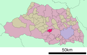
Elevation=40.66 m above sea levelnihongo|Tsurugashima|鶴ヶ島市|Tsurugashima-shi is a city located in Saitama, Japan.
As of
May 1 2008 , the city has an estimated population of 69,919 (27,720 households). The total area is 17.73 km².The city was founded when the town of Tsurugashima was upgraded to city status on
September 1 ,1991 .The city is served by
Tsurugashima Station on theTōbu Tōjō Line and also Ippommatsu Station on theTōbu Ogose Line .Wakaba Station on the Tōbu Tōjō Line lies on the city boundary between Tsurugashima and Sakado. Tsurugashima Station is approximately 40 minutes fromIkebukuro Station inTokyo on the Tōbu Tōjō Line by direct express train.Adjoining cities and towns
*Kawagoe
*Sakado
*Hidaka
*Moroyama, Irumahopping & eating
*Wakaba Walk Shopping Centre (Wakaba Station)
*Cainz Home (DIY store)
*Han's - Indian Restaurant (10 minutes' walk from Tsurugashima station)
*Bengaraya - Tantanmen (ramen) (5 minutes' walk from Wakaba station)
*Little London - British-owned restaurant (opposite Yomuyomu bookshop, near Inageya supermarket - 15 minutes' walk from Sakado station)External links
* [http://www.city.tsurugashima.lg.jp/ Tsurugashima official website] in Japanese

Wikimedia Foundation. 2010.