- National Register of Historic Places listings in Calhoun County, Alabama
-
 Location of Calhoun County in Alabama
This is a list of the National Register of Historic Places listings in Calhoun County, Alabama.
This is intended to be a complete list of the properties and districts on the National Register of Historic Places in Calhoun County, Alabama, United States. Latitude and longitude coordinates are provided for many National Register properties and districts; these locations may be seen together in a Google map.[1]
There are 61 properties and districts listed on the National Register in the county.
-
- This National Park Service list is complete through NPS recent listings posted November 10, 2011.[2]
Current listings
[3] Landmark name Image Date listed Location City or town Summary 1 Aderholdt's Mill 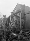
December 29, 1988 Aderholdt's Mill Rd.
33°46′40″N 85°46′12″W / 33.777778°N 85.77°WJacksonville 2 Anniston Cotton Manufacturing Company October 3, 1985 215 W. 11th St.
33°39′34″N 85°50′06″W / 33.659444°N 85.835°WAnniston 3 Old Anniston Electric and Gas Company Plant May 16, 1991 2 W. 3rd St.
33°38′50″N 85°49′47″W / 33.647222°N 85.829722°WAnniston 4 Anniston Inn Kitchen May 8, 1973 130 W. 15th St.
33°39′48″N 85°49′57″W / 33.663333°N 85.8325°WAnniston 5 Anniston Transfer Company October 3, 1985 911 Wilmer Ave.
33°39′22″N 85°49′41″W / 33.656111°N 85.828056°WAnniston 6 Bagley-Cater Building October 3, 1985 15 E. 10th St.
33°44′50″N 85°49′40″W / 33.747222°N 85.827778°WAnniston 7 Bank of Anniston October 3, 1985 1005 Noble St.
33°39′25″N 85°49′46″W / 33.656944°N 85.829444°WAnniston 8 Caldwell Building March 1, 1982 1001 Noble St.
33°39′25″N 85°49′46″W / 33.656944°N 85.829444°WAnniston 9 Calhoun County Courthouse October 3, 1985 25 W. 11th St.
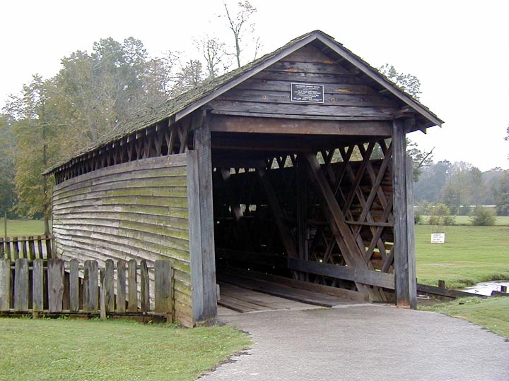
33°39′30″N 85°49′52″W / 33.658333°N 85.831111°WAnniston 10 Coldwater Creek Covered Bridge 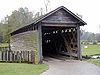
April 11, 1973 Spans Coldwater Creek 0.5 miles (0.8 km) from Interstate 20
33°35′10″N 85°54′47″W / 33.586111°N 85.913056°WColdwater 11 Davis C. Cooper House August 12, 2005 301 Main St.
33°37′01″N 85°50′03″W / 33.616944°N 85.834167°WOxford 12 Crowan Cottage May 16, 1975 1401 Woodstock Ave.
33°39′44″N 85°49′12″W / 33.662222°N 85.82°WAnniston 13 Downtown Anniston Historic District May 30, 1991 Roughly bounded by Moore Ave., 14th St., Wilmer Ave., and 9th St.
33°39′32″N 85°49′52″W / 33.65889°N 85.83111°W
Boundary increase (listed May 24, 2010): Bounded by Wilmer & Walnut Aves., W. 9th & 14th Sts.Anniston 14 Downtown Jacksonville Historic District May 13, 1986 Roughly bounded by College, Thomas, Coffee, and Spring Sts.
33°48′47″N 85°45′36″W / 33.813056°N 85.76°WJacksonville 15 East Anniston Residential Historic District May 28, 1993 Roughly along Leighton and Christine Aves. from 11th St. to 22nd Sts. and Woodstock Ave. from 11th St. to Rocky Hollow
33°39′51″N 85°49′21″W / 33.664167°N 85.8225°WAnniston 16 First Presbyterian Church February 4, 1982 200 E. Clinton St.
33°48′52″N 85°46′55″W / 33.814444°N 85.781944°WJacksonville 17 Fort McClellan Ammunition Storage Historic District November 8, 2006 Pappy Dunn Boulevard
33°43′40″N 85°46′37″W / 33.727778°N 85.776944°WAnniston 18 Fort McClellan Industrial Historic District November 8, 2006 Jimmy Parks Boulevard, Transportation Rd., Idaho Ave.
33°43′04″N 85°47′25″W / 33.717778°N 85.790278°WAnniston 19 Fort McClellan Post Headquarters Historic District November 8, 2006 Buckner Circle, Headquarters Ave., Drennan Dr.
33°43′01″N 85°47′47″W / 33.716944°N 85.796389°WAnniston 20 Fort McClellan World War II Housing Historic District November 8, 2006 Breman Rd., Bachelor Dr., Iron Mountain Rd., and Micron Way
33°43′12″N 85°46′36″W / 33.72°N 85.776667°WAnniston 21 Dr. J.C. Francis Office November 20, 1970 100 Gayle St.
33°48′51″N 85°45′43″W / 33.814167°N 85.761944°WJacksonville 22 Glen Addie Volunteer Hose Company Fire Hall October 3, 1985 Fourth St. and Pine Ave.
33°38′55″N 85°50′12″W / 33.648611°N 85.836667°WAnniston 23 Glenwood Terrace Residential Historic District October 3, 1985 Roughly bounded by Oak St., Jefferson Ave., lots on the southern side of Glenwood Terrace, the northern side of Orchard St., and Highland Ave.
33°39′16″N 85°49′01″W / 33.654444°N 85.816944°WAnniston 24 Henry Burt Glover House October 3, 1985 1119 Leighton Ave.
33°39′32″N 85°49′29″W / 33.658889°N 85.824722°WAnniston 25 Grace Episcopal Church October 3, 1985 1000 Leighton Ave.
33°39′27″N 85°49′31″W / 33.6575°N 85.825278°WAnniston 26 Greenwood March 9, 1989 Junction of Old Anniston-Gadsden Rd. and County Road 25
33°46′21″N 85°52′48″W / 33.7725°N 85.88°WAlexandria 27 Charles B. Henry Barn September 26, 1997 0.5 miles west of State Route 21, south of Branscomb Dr. and north of Henry Rd.
33°47′12″N 85°46′01″W / 33.786667°N 85.766944°WJacksonville 28 Hillside Cemetery October 3, 1985 Highland Ave. between 10th and 11th Sts.
33°39′27″N 85°49′04″W / 33.6575°N 85.817778°WAnniston 29 Richard P. Huger House October 3, 1985 1901 Wilmer Ave.
33°40′08″N 85°49′41″W / 33.668889°N 85.828056°WAnniston 30 Janney Furnace September 28, 1976 1 mile northwest of Ohatchee off State Route 62
33°47′41″N 86°01′14″W / 33.794722°N 86.020556°WOhatchee 31 Kilby House October 3, 1985 1301 Woodstock Ave.
33°39′36″N 85°49′13″W / 33.66°N 85.820278°WAnniston 32 Kress Building October 3, 1985 1106 Noble St.
33°39′31″N 85°49′48″W / 33.658611°N 85.83°WAnniston 33 Lyric Theatre May 22, 1980 1302 Noble St.
33°39′40″N 85°49′49″W / 33.661111°N 85.830278°WAnniston 34 McKleroy-Wilson-Kirby House August 30, 1984 1604 Quintard Ave.
33°39′55″N 85°49′39″W / 33.665278°N 85.8275°WAnniston 35 Montgomery Ward-Alabama Power Company Building October 3, 1985 1201 Noble St.
33°39′35″N 85°49′46″W / 33.659722°N 85.829444°WAnniston 36 Mount Zion Baptist Church October 3, 1985 212 2nd St.
33°38′47″N 85°49′58″W / 33.646389°N 85.832778°WAnniston 37 Noble Cottage October 8, 1976 900 Leighton Ave.
33°39′20″N 85°49′31″W / 33.655556°N 85.825278°WAnniston 38 Samuel Noble Monument October 3, 1985 11th St. and Quintard Ave.
33°39′29″N 85°49′36″W / 33.658056°N 85.826667°WAnniston 39 Noble-McCaa-Butler House October 3, 1985 1025 Fairmont Ave.
33°39′28″N 85°49′11″W / 33.657778°N 85.819722°WAnniston 40 Nonnenmacher Bakery October 3, 1985 36 W. 11th St.
33°39′28″N 85°49′52″W / 33.657778°N 85.831111°WAnniston 41 Nonnenmacher House October 3, 1985 1311 Gurnee Ave.
33°39′41″N 85°49′52″W / 33.661389°N 85.831111°WAnniston 42 Oak Tree Cottage October 3, 1985 721 Oak St.
33°39′18″N 85°49′08″W / 33.655°N 85.818889°WAnniston 43 Parker Memorial Baptist Church October 3, 1985 1205 Quintard Ave.
33°39′36″N 85°49′34″W / 33.66°N 85.826111°WAnniston 44 Parker-Reynolds House February 19, 1982 330 E. 6th St.
33°39′36″N 85°49′34″W / 33.66°N 85.826111°WAnniston 45 Peerless Saloon October 3, 1985 13 W. 10th St.
33°39′25″N 85°49′51″W / 33.656944°N 85.830833°WAnniston 46 Profile Cotton Mills Historic District May 31, 2006 Alexandria St., A St., H St., and D St.
33°48′44″N 85°46′21″W / 33.812222°N 85.7725°WJacksonville 47 St. Michael and All Angels Episcopal Church February 14, 1978 W. 18th St.
33°40′00″N 85°50′36″W / 33.666667°N 85.843333°WAnniston 48 Saint Paul's Methodist Episcopal Church October 3, 1985 1327 Leighton Ave.
33°39′40″N 85°49′29″W / 33.661111°N 85.824722°WAnniston 49 Security Bank Building October 3, 1985 1030 Noble St.
33°39′28″N 85°49′47″W / 33.657778°N 85.829722°WAnniston 50 Lansing T. Smith House October 3, 1985 531 Keith Ave.
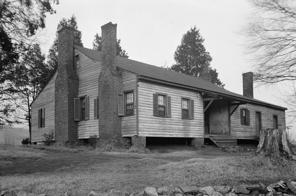
33°39′04″N 85°50′28″W / 33.651111°N 85.841111°WAnniston 51 Dudley Snow House 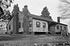
February 4, 1982 704 Snow St.
33°36′54″N 85°49′26″W / 33.615°N 85.823889°WOxford 52 Southern Railway Depot January 5, 1984 200 N. Center Ave.
33°55′29″N 85°36′40″W / 33.924722°N 85.611111°WPiedmont 53 Temple Beth-El October 3, 1985 301 E. 13th St.
33°39′40″N 85°49′33″W / 33.661111°N 85.825833°WAnniston 54 Ten Oaks November 29, 2001 805 Pelham Rd., S.
33°48′32″N 85°45′44″W / 33.808889°N 85.762222°WJacksonville 55 The Pines May 13, 1991 Southeastern corner of 5th St. and Lapsley Ave.
33°38′59″N 85°49′21″W / 33.649722°N 85.8225°WAnniston 56 Tyler Hill Residential Historic District October 3, 1985 Roughly bounded by E. 7th, Knox and Goodwin and Lapsley Aves., E. 6th St., and Leighton Ave.
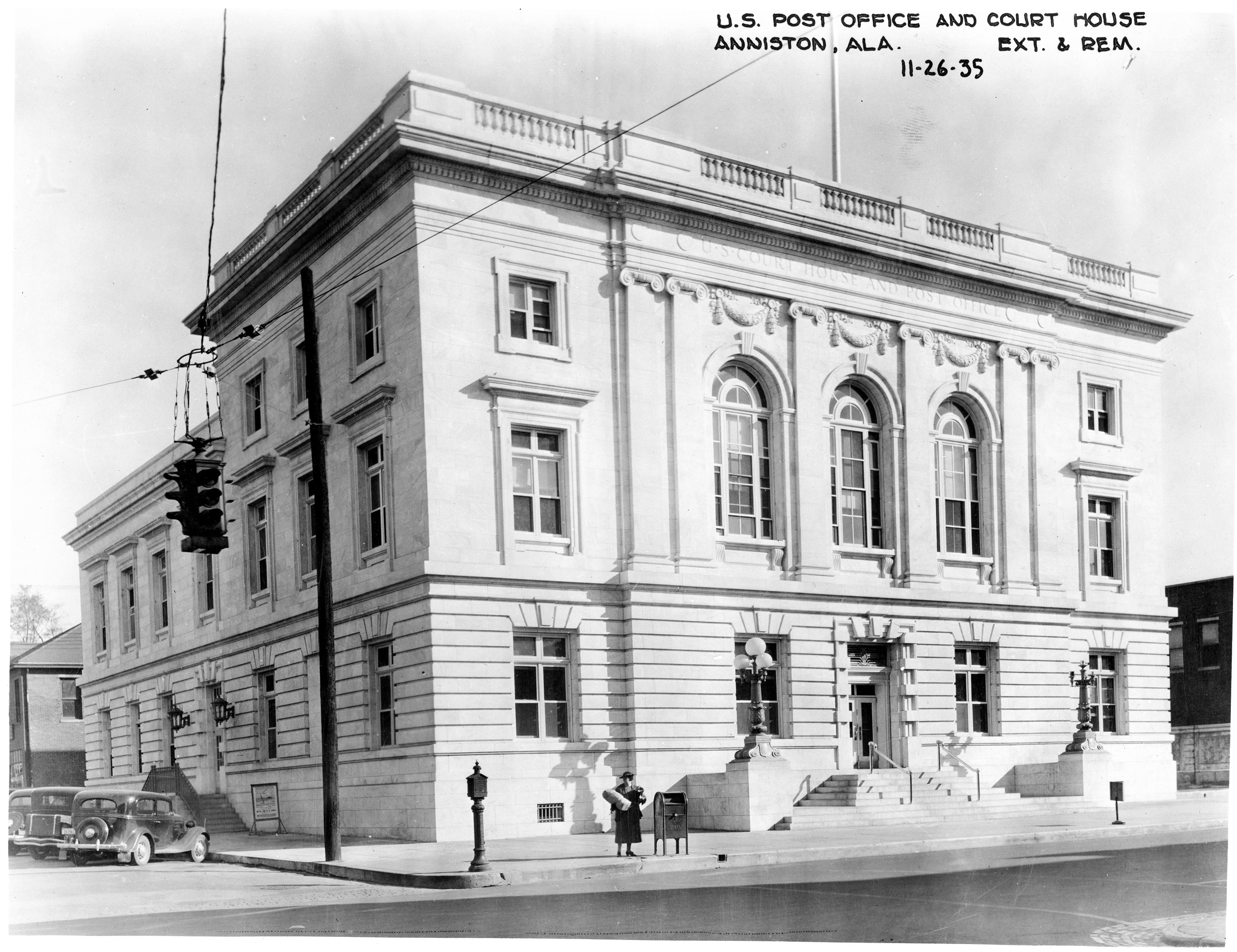
33°39′05″N 85°49′24″W / 33.651389°N 85.823333°WAnniston 57 U.S. Post Office 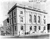
November 13, 1976 1129 Noble St.
33°39′33″N 85°49′45″W / 33.659167°N 85.829167°WAnniston 58 Union Depot and Freight House October 3, 1985 1300 Walnut Ave.
33°39′39″N 85°50′01″W / 33.660833°N 85.833611°WAnniston 59 West Fifteenth Street Historic District May 30, 1991 416-712 W. 15th St.
33°39′48″N 85°50′13″W / 33.663333°N 85.836944°WAnniston 60 Wikle Drug Company October 3, 1985 1010 Noble St.
33°39′25″N 85°49′47″W / 33.656944°N 85.829722°WAnniston 61 Alexander Woods House March 15, 1988 517 N. Pelham Rd.
33°49′13″N 85°45′40″W / 33.820278°N 85.761111°WJacksonville See also
- List of National Historic Landmarks in Alabama
- National Register of Historic Places listings in Alabama
References
- ^ The latitude and longitude information provided in this table was derived originally from the National Register Information System, which has been found to be fairly accurate for about 99% of listings. For about 1% of NRIS original coordinates, experience has shown that one or both coordinates are typos or otherwise extremely far off; some corrections may have been made. A more subtle problem causes many locations to be off by up to 150 yards, depending on location in the country: most NRIS coordinates were derived from tracing out latitude and longitudes off of USGS topographical quadrant maps created under the North American Datum of 1927, which differs from the current, highly accurate WGS84 GPS system used by Google maps. Chicago is about right, but NRIS longitudes in Washington are higher by about 4.5 seconds, and are lower by about 2.0 seconds in Maine. Latitudes differ by about 1.0 second in Florida. Some locations in this table may have been corrected to current GPS standards.
- ^ "National Register of Historic Places: Weekly List Actions". National Park Service, United States Department of the Interior. Retrieved on November 10, 2011.
- ^ Numbers represent an ordering by significant words. Various colorings, defined here, differentiate National Historic Landmark sites and National Register of Historic Places Districts from other NRHP buildings, structures, sites or objects.
U.S. National Register of Historic Places in Alabama Lists by county Autauga • Baldwin • Barbour • Bibb • Blount • Bullock • Butler • Calhoun • Chambers • Cherokee • Chilton • Choctaw • Clarke • Clay • Cleburne • Coffee • Colbert • Conecuh • Coosa • Covington • Crenshaw • Cullman • Dale • Dallas • DeKalb • Elmore • Escambia • Etowah • Fayette • Franklin • Geneva • Greene • Hale • Henry • Houston • Jackson • Jefferson • Lamar • Lauderdale • Lawrence • Lee • Limestone • Lowndes • Macon • Madison • Marengo • Marion • Marshall • Mobile • Monroe • Montgomery • Morgan • Perry • Pickens • Pike • Randolph • Russell • St. Clair • Shelby • Sumter • Talladega • Tallapoosa • Tuscaloosa • Walker • Washington • Wilcox • Winston
Lists by city Other lists Municipalities and communities of Calhoun County, Alabama Cities 
Towns CDPs Unincorporated
communityGhost town Footnotes ‡This populated place also has portions in an adjacent county or counties
Categories:- National Register of Historic Places in Calhoun County, Alabama
-


Wikimedia Foundation. 2010.