- Croston
-
Coordinates: 53°39′45″N 2°46′37″W / 53.662529°N 2.777067°W
Croston 
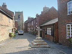
Church Street, Croston Village Centre
 Croston shown within Lancashire
Population 2,679 (2001 Census) OS grid reference SD487187 Parish Croston District Chorley Shire county Lancashire Region North West Country England Sovereign state United Kingdom Post town LEYLAND Postcode district PR25,PR26 Dialling code 01257/01772 Police Lancashire Fire Lancashire Ambulance North West EU Parliament North West England UK Parliament Chorley List of places: UK • England • Lancashire Croston is a village and civil parish in Lancashire, England between Chorley and Southport and is next to the River Yarrow. St. Michael's and All Angels' Church is at the centre of the village. At the end of Church Street there is a stone cross which was erected in 1953. There is a 15th century cobbled pack horse bridge which crosses the River Yarrow. The village green is used as a venue for the annual May Day Madness and Bastille Day (14 July) celebrations.
Contents
History
Croston began in the 7th century when St. Aidan arrived at the riverside settlements. In the absence of a church, a cross erected as a place of worship. Croston gets its name from 'cross' derived from the Irish and the Scandinavian word 'tun' which means town (cross-town). It is unique as there are no other Crostons in the UK.
Centuries ago the parish of Croston was far larger than it is today[citation needed]. It included Chorley, Much Hoole, Rufford, Bretherton, Mawdesley, Tarleton, Hesketh Bank, Bispham, Walmer Bridge and Ulnes Walton. A charter granted by Edward I in 1283 permitted an annual medieval fair and market to be held on the village green. Ancient maps also depict a castle which is believed to have been of a wooden construction because there is no evidence of a stone structure.
Croston used to have a large brick police station which has recently been refurbished. It was replaced by a smaller police station in the 1970s. It is similar in style to those in the surrounding areas, notably Bamber Bridge and Leyland police stations, however considerably smaller.
Croston Hall
Croston Hall was built by the De Trafford family and was the manor house to the village of Croston. The Hall was demolished in the 1960s, but there is a plan for a Country House hotel to be built on its site. The family was Roman Catholic, they built a church in the grounds of the house, it was left to the people of Croston on the death of the last De Trafford in the 1960s.
Croston Old School
Croston Old School is a Grade 2 listed building which originates from 1660. It is situated in the centre of the village at the end of Church Street and next to the 900 year old church. Until 1999 the buildings were used as a school. Croston Old School Community Trust's grant from the National Lottery for £481,062 has funded the majority of a scheme to create a Community Resource Centre for Croston.
The building provides:
- A new home for Croston Pre-school
- A large community space with meeting rooms
- An exhibition area for local arts and heritage projects
- A reference library and a reading room
- Space for adult education
Bishop Rawstorne C of E Language College
Bishop Rawstorne C of E Language College is the secondary school that is based in the village of Croston. The school has between 800-900 pupils between the ages of 11 and 16 years of age.
Geography

Bretherton Midge Hall Leyland 
Sollom 
Ulnes Walton  Croston

Rufford Mawdesley Eccleston See also
External links
Categories:- Geography of Chorley
- Villages in Lancashire
- Civil parishes in Lancashire
- Lancashire geography stubs
Wikimedia Foundation. 2010.

