- Tupungato
-
Tupungato 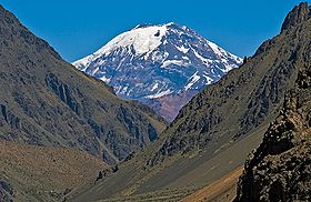
Tupungato volcano seen from Punta de Vacas, Argentina.Elevation 6,570 m (21,555 ft) [1] Prominence 2,765 m (9,072 ft) [2] Listing Ultra Location Location Mendoza Province, Argentina Range Andes Coordinates 33°21′16″S 69°46′07″W / 33.35444°S 69.76861°WCoordinates: 33°21′16″S 69°46′07″W / 33.35444°S 69.76861°W Geology Type Stratovolcano Age of rock Pleistocene Volcanic arc/belt South Volcanic Zone Last eruption 1987 Climbing First ascent 1897 by Matthias Zurbriggen and Stuart Vines 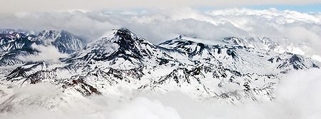 Aerial view of Tupungato (center-left) and Tupungatito.
Tupungato, one of the highest mountains in South America, is a massive stratovolcano dating to Pleistocene times. It lies on the border between the Chilean Metropolitan Region and the province of Mendoza, Argentina, near a major international highway about 80 km (50 mi) east of Santiago, Chile. It is located about 100 km (62 mi) south of Monte Aconcagua, the highest peak of the American continent. Immediately to its southwest lies the active Tupungatito volcano, which last erupted in 1987.
The mountain gives its name to the Tupungato Department an important Argentine wine producing region in the Mendoza province, Argentina.
Contents
1947 plane crash
Main article: Star Dust (aircraft)On August 2, 1947, the airliner Star Dust, an Avro Lancastrian carrying six passengers and five crew over the Andes range, crashed into a steep glacier high on Tupungato. The plane was quickly buried in the resulting avalanche and heavy snowfall that was taking place at the time. The plane lay undetected deep beneath the snow and glacial ice for over 50 years, before its remnants finally re-emerged at the glacier terminus in 2000. Shortly thereafter, a team discovered the scattered debris and wreckage, collecting some of the evidence for investigation.
See also
References
- "Tupungatito". Global Volcanism Program, Smithsonian Institution. http://www.volcano.si.edu/world/volcano.cfm?vnum=1507-01=.
- ^ The given elevation of 6,570 meters comes from Chilean 1:50.000 topographic mapping and is in accordance with SRTM data; the frequently given elevation of 6,800 meters is incorrect.
- ^ Peaklist.org
External links
- Pictures of Mount Tupungato
- Technical information
- Star Dust Plane Crash Mystery
- Andes Mountains (Spanish) [1]
Andean volcanoes Northern Volcanic Zone (6° N–3° S) Nevado del Ruiz · Nevado del Huila · Galeras · Cayambe · Reventador · Pichincha · Antisana · Illiniza · Cotopaxi · Quilotoa · Tungurahua · SangayCentral Volcanic Zone (15°–27° S) Ampato · Coropuna · Sabancaya · Chachani · El Misti · Ubinas · Huaynaputina · Parinacota · Irruputuncu · Azufre · Sairecabur · Pacana · Licancabur · Lascar · Llullaillaco · Galán · San Francisco · Ojos del SaladoSouthern Volcanic Zone (33°–46° S) Tupungato · Tupungatito · Maipo · Calabozos · Descabezado Grande · Cerro Azul · Nevado de Longaví · Nevados de Chillán · Antuco · Copahue · Callaqui · Lonquimay · Llaima · Sollipulli · Villarrica · Quetrupillán · Lanín · Mocho-Choshuenco · Carrán-Los Venados · Puyehue-Cordón Caulle · Osorno · Calbuco · Hornopirén · Michinmahuida · Chaitén · Corcovado · Cay · Macá · HudsonAustral Volcanic Zone (49°–55° S) Note: volcanoes are ordered by latitude from north to southCategories:- Geography of Mendoza Province
- Volcanoes of Santiago Metropolitan Region
- Volcanoes of Chile
- Mountains of Chile
- Volcanoes of Argentina
- Mountains of Argentina
- South Volcanic Zone
- Polygenetic volcanoes
- Chile geography stubs


Wikimedia Foundation. 2010.