- Maipo (volcano)
-
Maipo
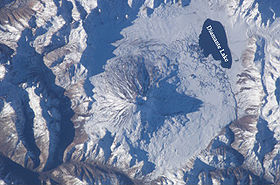
Satellite image of MaipoElevation 5,264 m (17,270 ft) [1] Location Location Argentina-Chile Range Andes Coordinates 34°09′39.6″S 69°49′58.8″W / 34.161°S 69.833°WCoordinates: 34°09′39.6″S 69°49′58.8″W / 34.161°S 69.833°W Geology Type Stratovolcano Last eruption 1908 Climbing First ascent 1883 by Paul Güssfeldt[2] Easiest route snow/ice climb Maipo is a stratovolcano in the Andes, lying on the border between Argentina and Chile. It is located 90 km (56 mi) south of Tupungato and about 100 km (62 mi) southeast of Santiago.
Maipo retains a symmetrical, conical volcanic shape, unlike many of the other nearby peaks, making it the best known peak in the region, though it is not the highest. (Nearby Castillo is 5,485 m high.)[3] Maipo is also almost the southernmost 5,000 metre peak in the Andes. (That honor goes to Sosneado, about 50 km to the south).
Maipo is located within the Diamante Caldera, a feature of about 15 km by 20 km size that is about one-half million years old. It rises about 1,900 m (6,230 ft) above the floor of the caldera. Immediately to the east of the peak, on the eastern side of the caldera floor, is Laguna del Diamante, a picturesque lake that formed when lava flows blocked drainage channels from the caldera in 1826. The Diamante Caldera erupted 450 cubic kilometers (108 cu mi) of tephra, 450 ka.[4]
The region's climate is transitional between the drier Mediterranean climate of the peaks to the north and the cold, moist climate of Chilean Patagonia. Hence, while less glaciated than Patagonia, it has more permanent snow (on the wet, Chilean side) than peaks of similar elevation to the north.[3]
See also
References
- Volcan Maipo or Maipú (span.) [1]
- "Maipo". Global Volcanism Program, Smithsonian Institution. http://www.volcano.si.edu/world/volcano.cfm?vnum=1507-021.
- Sruoga, P.; Llambías, E.J., Fauqué, L., Schonwandt, D., and Repol, D.G. (2005). "Volcanological and geochemical evolution of the Diamante Caldera-Maipo volcano complex in the Southern Andes of Argentina (34°10’S)". J. South American Earth Sci. 19: 399–414.
- ^ The given height is supported by SRTM data. Higher elevations given by some other authorities are incorrect.
- ^ Neate, Jill (1994). "Central Chile". Mountaineering in the Andes (2nd Edition ed.). Expedition Advisory Centre. ISBN 0-907649-64-5. http://www.rgs.org/OurWork/Publications/EAC+publications/Mountaineering+in+the+Andes.htm.
- ^ a b Michael R. Kelsey, Climbers and Hikers Guide to the World's Mountains (Third Edition), Kelsey Publishing, 1990, ISBN 0-944510-02-7
- ^ "Supplementary Table to P.L. Ward, Thin Solid Films (2009) Major volcanic eruptions and provinces". Teton Tectonics. http://www.tetontectonics.org/Climate/Table_S1.pdf. Retrieved 2010-03-16.
Andean volcanoes Northern Volcanic Zone (6° N–3° S) Nevado del Ruiz · Nevado del Huila · Galeras · Cayambe · Reventador · Pichincha · Antisana · Illiniza · Cotopaxi · Quilotoa · Tungurahua · SangayCentral Volcanic Zone (15°–27° S) Ampato · Coropuna · Sabancaya · Chachani · El Misti · Ubinas · Huaynaputina · Parinacota · Irruputuncu · Azufre · Sairecabur · Pacana · Licancabur · Lascar · Llullaillaco · Galán · San Francisco · Ojos del SaladoSouthern Volcanic Zone (33°–46° S) Tupungato · Tupungatito · Maipo · Calabozos · Descabezado Grande · Cerro Azul · Nevado de Longaví · Nevados de Chillán · Antuco · Copahue · Callaqui · Lonquimay · Llaima · Sollipulli · Villarrica · Quetrupillán · Lanín · Mocho-Choshuenco · Carrán-Los Venados · Puyehue-Cordón Caulle · Osorno · Calbuco · Hornopirén · Michinmahuida · Chaitén · Corcovado · Cay · Macá · HudsonAustral Volcanic Zone (49°–55° S) Note: volcanoes are ordered by latitude from north to southCategories:- Geography of Mendoza Province
- Volcanoes of Santiago Metropolitan Region
- Stratovolcanoes of Chile
- Subduction volcanoes
- Active volcanoes
- VEI-7 volcanoes
- Stratovolcanoes of Argentina
- Argentina–Chile border
- International mountains of South America
- Chile geography stubs
- Argentina geography stubs
Wikimedia Foundation. 2010.


