- Copahue
-
Copahue 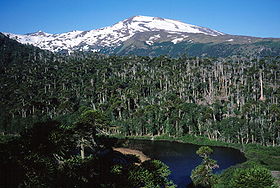
Copahue's southwest face with Laguna Las Totoras in the foreground.Elevation 2,997 m (9,833 ft) [1] Location Location on Argentina/Chile border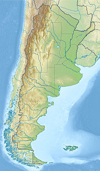
 Copahue
Location Argentina and Chile Range Andes Coordinates 37°51′S 71°10′W / 37.85°S 71.167°WCoordinates: 37°51′S 71°10′W / 37.85°S 71.167°W[1] Geology Type Stratovolcano Last eruption 2000[1] Copahue is a stratovolcano on the border between Argentina and Chile. There are nine volcanic craters along a 2 km (1.2 mi) line, and the eastern summit crater contains a briny, acidic 300 m (1000 ft) wide crater lake. Twentieth-century eruptions from the crater lake have ejected pyroclastic rocks and chilled liquid sulfur fragments. [1]
Contents
Geology and Geography
Copahue sits on a basement of sedimentary and volcanic rocks ranging from the Eocene to the Pliocene[2]. The modern volcano sits in a volcanically active area, with a caldera from the Pliocene, measuring 20 km by 15 km, lying to the east of Copahue. The modern
 Copahue Crater Lake.
volcano became active roughly 1.2 Ma[2]. The modern caldera formed .6 to .4 Ma, and produced large pyroclastic flows, extending up to 37 kilometers from the volcano[2].
The modern structure is an elongated shield volcano, with a maximum thickness of 22 kilometers and a minimum of 8 kilometers[2]. There have been at least 6 eruptions within the Holocene, with the most recent in 2000. The easternmost (and most active) crater contains a crater lake with a pH ranging between .18 and .30[2]. While it emptied during the 2000 eruption, it has returned to its previous levels.
References
- ^ a b c d "Copahue". Global Volcanism Program, Smithsonian Institution. http://www.volcano.si.edu/world/volcano.cfm?vnum=1507-09=. Retrieved 2005-02-11.
- ^ a b c d e Naranjo, Jose; Polanco, Edmundo (2004). "The 2000 AD eruption of Copahue Volcano, Southern Andes". Revisita Geologica de Chile 31 (2): 279–292.
Bibliography
- González-Ferrán, Oscar (1995). Volcanes de Chile. Santiago, Chile: Instituto Geográfico Militar. p. 640 pp. ISBN 956-202-054-1. (in Spanish; also includes volcanoes of Argentina, Bolivia, and Peru)
- Biggar, John (2005). The Andes: A Guide for Climbers (3rd ed.). Andes Publishing (Scotland). p. 304 pp. ISBN 0-9536087-2-7. http://www.andes.org.uk/.
See also
Andean volcanoes Northern Volcanic Zone (6° N–3° S) Nevado del Ruiz · Nevado del Huila · Galeras · Cayambe · Reventador · Pichincha · Antisana · Illiniza · Cotopaxi · Quilotoa · Tungurahua · SangayCentral Volcanic Zone (15°–27° S) Ampato · Coropuna · Sabancaya · Chachani · El Misti · Ubinas · Huaynaputina · Parinacota · Irruputuncu · Azufre · Sairecabur · Pacana · Licancabur · Lascar · Llullaillaco · Galán · San Francisco · Ojos del SaladoSouthern Volcanic Zone (33°–46° S) Tupungato · Tupungatito · Maipo · Calabozos · Descabezado Grande · Cerro Azul · Nevado de Longaví · Nevados de Chillán · Antuco · Copahue · Callaqui · Lonquimay · Llaima · Sollipulli · Villarrica · Quetrupillán · Lanín · Mocho-Choshuenco · Carrán-Los Venados · Puyehue-Cordón Caulle · Osorno · Calbuco · Hornopirén · Michinmahuida · Chaitén · Corcovado · Cay · Macá · HudsonAustral Volcanic Zone (49°–55° S) Note: volcanoes are ordered by latitude from north to south Categories:- Active volcanoes
- Volcanoes of Bío-Bío Region
- Geography of Neuquén Province
- Stratovolcanoes of Chile
- Subduction volcanoes
- Stratovolcanoes of Argentina
- Crater lakes
- Argentina–Chile border
- International mountains of South America
- Argentina geography stubs
- Biobío Region geography stubs


Wikimedia Foundation. 2010.