- Aguilera (volcano)
-
Aguilera 
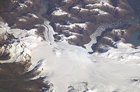
The volcano is visible in the leftmost portion of the image.Elevation 2,546 m (8,353 ft) [1] Location Location Chile Range Andes Coordinates 50°20′0″S 73°45′0″W / 50.333333°S 73.75°W Geology Type Caldera Last eruption 1650 BC ± 200 years[1] Aguilera (e. 2546 m/8353 ft.) is a stratovolcano in southern Chile, which rises above the edge of the Southern Patagonian Ice Field.
It is located west of Lake Argentino and northeast of Peel Fjord in the southern Andes.
References
- ^ a b "Aguilera". Global Volcanism Program, Smithsonian Institution. http://www.volcano.si.edu/world/volcano.cfm?vnum=1508-062.
Andean volcanoes Northern Volcanic Zone (6° N–3° S) Nevado del Ruiz · Nevado del Huila · Galeras · Cayambe · Reventador · Pichincha · Antisana · Illiniza · Cotopaxi · Quilotoa · Tungurahua · SangayCentral Volcanic Zone (15°–27° S) Ampato · Coropuna · Sabancaya · Chachani · El Misti · Ubinas · Huaynaputina · Parinacota · Irruputuncu · Azufre · Sairecabur · Pacana · Licancabur · Lascar · Llullaillaco · Galán · San Francisco · Ojos del SaladoSouthern Volcanic Zone (33°–46° S) Tupungato · Tupungatito · Maipo · Calabozos · Descabezado Grande · Cerro Azul · Nevado de Longaví · Nevados de Chillán · Antuco · Copahue · Callaqui · Lonquimay · Llaima · Sollipulli · Villarrica · Quetrupillán · Lanín · Mocho-Choshuenco · Carrán-Los Venados · Puyehue-Cordón Caulle · Osorno · Calbuco · Hornopirén · Michinmahuida · Chaitén · Corcovado · Cay · Macá · HudsonAustral Volcanic Zone (49°–55° S) Note: volcanoes are ordered by latitude from north to southCategories:- Volcanoes of Magallanes Region
- Mountains of Chile
- Stratovolcanoes of Chile
- Magellan and Chilean Antarctic Region geography stubs
Wikimedia Foundation. 2010.
