- Sollipulli
-
Sollipulli 
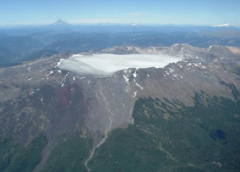
Aerial photograph of volcan Sollipulli, looking south. In the background are Lanín (to the left) and Villarrica volcanoes. In the foreground, the red patch on the side of Sollipulli is the cinder cone called Chufquen which formed during the most recent eruption, about 700 years ago.Elevation 2,282 m (7,487 ft) [1] Listing List of volcanoes in Chile Location Location Southern Chile Range Andes Coordinates 38°58′0″S 71°31′0″W / 38.966667°S 71.516667°WCoordinates: 38°58′0″S 71°31′0″W / 38.966667°S 71.516667°W[1] Geology Type Caldera Volcanic arc/belt Southern Volcanic Zone of the Andes Last eruption 1240 ± 50 years[1] 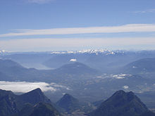 Nevados de Sollipulli as seen from Villarrica Volcano
Sollipulli is an ice-filled volcanic caldera, which lies about 12 kilometres south of the small town of Melipeuco in the Araucanía Region, Chile. Volcan Sollipulli lies northeast of Caburgua Lake and southeast of Llaima volcano; and there are views to at least seven active volcanoes from the summit rim. The volcano has evolved in close contact with glacial ice and has some typical subglacial volcanic features such as hyaloclastite breccia and pillow lava. It differs from many calderas in that Sollipulli appears to have collapsed in a non-explosive manner. The age of collapse is not yet known, but since the caldera formed, volcanic activity has continued along the surrounding ring faults which have produced lava flows and lava domes, increasing the elevation of the caldera wall. The caldera is 4 km in average diameter and according to ground penetrating radar measurements made in 1993 it contained a maximum ice thickness of at least 550 m, but perhaps as much as 650 m, at that time.[2][3]
References
- ^ a b c "Sollipulli". Global Volcanism Program, Smithsonian Institution. http://www.volcano.si.edu/world/volcano.cfm?vnum=1507-111. Retrieved 2008-01-06.
- ^ "VGRG in Chile:Volcán Sollipulli". Lancaster University. http://www.es.lancs.ac.uk/vgrg/Fieldareas/chile.html. Retrieved 2008-01-06.
- ^ Gilbert, J. S.; M. V. Stasiuk1, S. J. Lane, C. R. Adam, M. D. Murphy, R. S. J. Sparks and J. A. Naranjo (1996). "Non-explosive, constructional evolution of the ice-filled caldera at Volcán Sollipulli, Chile". Bulletin of Volcanology (Springer) 58: 67–83. doi:10.1007/s004450050127. http://www.springerlink.com/content/uqc5hf9j8qwvh7w9/. Retrieved 20 April 2009.
Andean volcanoes Northern Volcanic Zone (6° N–3° S) Nevado del Ruiz · Nevado del Huila · Galeras · Cayambe · Reventador · Pichincha · Antisana · Illiniza · Cotopaxi · Quilotoa · Tungurahua · SangayCentral Volcanic Zone (15°–27° S) Ampato · Coropuna · Sabancaya · Chachani · El Misti · Ubinas · Huaynaputina · Parinacota · Irruputuncu · Azufre · Sairecabur · Pacana · Licancabur · Lascar · Llullaillaco · Galán · San Francisco · Ojos del SaladoSouthern Volcanic Zone (33°–46° S) Tupungato · Tupungatito · Maipo · Calabozos · Descabezado Grande · Cerro Azul · Nevado de Longaví · Nevados de Chillán · Antuco · Copahue · Callaqui · Lonquimay · Llaima · Sollipulli · Villarrica · Quetrupillán · Lanín · Mocho-Choshuenco · Carrán-Los Venados · Puyehue-Cordón Caulle · Osorno · Calbuco · Hornopirén · Michinmahuida · Chaitén · Corcovado · Cay · Macá · HudsonAustral Volcanic Zone (49°–55° S) Note: volcanoes are ordered by latitude from north to southCategories:- Volcanic calderas of Chile
- Mountains of Chile
- Volcanoes of Araucanía Region
- Chile geography stubs
Wikimedia Foundation. 2010.