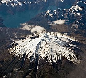
- Corcovado Volcano
-
Corcovado 

The volcano seen from the west on a commercial flight.Elevation 2,300 m (7,546 ft) Location Location Chile Range Andes Coordinates 43°11′S 72°48′W / 43.183°S 72.8°WCoordinates: 43°11′S 72°48′W / 43.183°S 72.8°W Geology Type Stratovolcano Last eruption 4920 BC ± 100 Corcovado Volcano is a stratovolcano located about 25 km south of the mouth of Yelcho River, in the Palena Province, Los Lagos Region, Chile. The glacially eroded volcano is flanked by Holocene cinder cones. The most distinctive feature of this volcano is its stepped top, similar to that of Puntiagudo Volcano. At its foot lies a series of beautiful lakes. Corcovado dominates the landscape of Gulf of Corcovado area and is visible from the Chiloé Island, weather allowing.
The volcano and the adjacent area form part of Corcovado National Park. The town of Chaitén was formerly the main gateway to this protected area.
See also
- List of volcanoes in Chile
- Chaitén (volcano) - the volcano 40 km North of Corcovado which erupted on May 2, 2008.
- Yanteles - a little known volcano located about 30 km (19 mi) south of Corcovado.
References
- "Corcovado". Global Volcanism Program, Smithsonian Institution. http://www.volcano.si.edu/world/volcano.cfm?vnum=1508-05=.
- González-Ferrán, Oscar (1995). Volcanes de Chile. Santiago, Chile: Instituto Geográfico Militar. p. 640 pp. ISBN 956-202-054-1. (in Spanish; also includes volcanoes of Argentina, Bolivia, and Peru)
Andean volcanoes Northern Volcanic Zone (6° N–3° S) Nevado del Ruiz · Nevado del Huila · Galeras · Cayambe · Reventador · Pichincha · Antisana · Illiniza · Cotopaxi · Quilotoa · Tungurahua · SangayCentral Volcanic Zone (15°–27° S) Ampato · Coropuna · Sabancaya · Chachani · El Misti · Ubinas · Huaynaputina · Parinacota · Irruputuncu · Azufre · Sairecabur · Pacana · Licancabur · Lascar · Llullaillaco · Galán · San Francisco · Ojos del SaladoSouthern Volcanic Zone (33°–46° S) Tupungato · Tupungatito · Maipo · Calabozos · Descabezado Grande · Cerro Azul · Nevado de Longaví · Nevados de Chillán · Antuco · Copahue · Callaqui · Lonquimay · Llaima · Sollipulli · Villarrica · Quetrupillán · Lanín · Mocho-Choshuenco · Carrán-Los Venados · Puyehue-Cordón Caulle · Osorno · Calbuco · Hornopirén · Michinmahuida · Chaitén · Corcovado · Cay · Macá · HudsonAustral Volcanic Zone (49°–55° S) Note: volcanoes are ordered by latitude from north to southCategories:- Volcanoes of Los Lagos Region
- Mountains of Chile
- Stratovolcanoes of Chile
- Los Lagos Region geography stubs
Wikimedia Foundation. 2010.

