- 2005 levee failures in Greater New Orleans
-
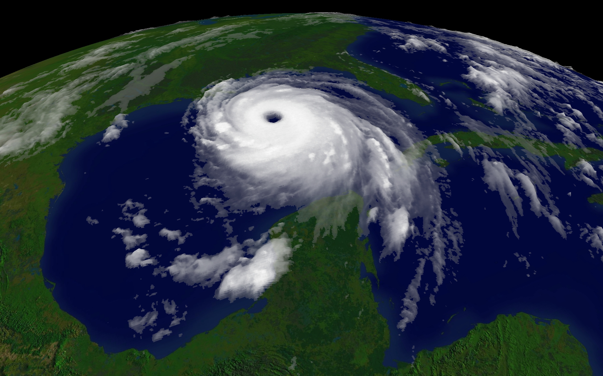
Hurricane Katrina 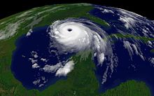
2005 Atlantic hurricane season General Impact Relief Analysis - Global warming
- Historical context
- Media coverage
External links  Media related to Hurricane Katrina at Wikimedia Commons
 News related to Katrina stories at Wikinews
 Works related to Katrina sources at Wikisource
In 29 August 2005 there were over 50 failures of the levees and flood walls protecting New Orleans, Louisiana, and its suburbs following passage of Hurricane Katrina and landfall in Mississippi. The levee and flood wall failures caused flooding in 80% of New Orleans and all of St. Bernard Parish. Tens of billions of gallons of water spilled into vast areas of New Orleans, flooding over 100,000 homes and businesses. Responsibility for the design and construction of the levee system belongs to the U.S. Army Corps of Engineers; the responsibility of maintenance belongs to the local levee boards. The Corps hands components of the system over to the local levee boards upon completion. When Katrina struck in 2005, the project was between 60-90% complete.[1] Five investigations (three major and two minor) were conducted by civil engineers and other experts, in an attempt to identify the underlying reasons for the failure of the federal flood protection system. All concur that the primary cause of the flooding was inadequate design and construction by the United States Army Corps of Engineers.
Storm surge caused breaches in 20 places on the Mississippi River-Gulf Outlet Canal ("MR-GO") flooding the entire Saint Bernard Parish and the East Bank of Plaquemines Parish.
Three major breaches occurred on the Industrial Canal; one on the northeast side near the junction with Gulf Intracoastal Waterway and two on the southeast side along the Lower Ninth Ward, between Florida Avenue and Claiborne Avenue. On the east side of New Orleans the 17th Street Canal levee breached 4 feet (1.2 m) below design specs on the New Orleans side near the Old Hammond Highway Bridge. The London Avenue Canal in the Gentilly neighborhood breached on both sides; on the west side near Robert E. Lee Boulevard, and on the east, near the Mirabeau Avenue Bridge.
Contents
Background
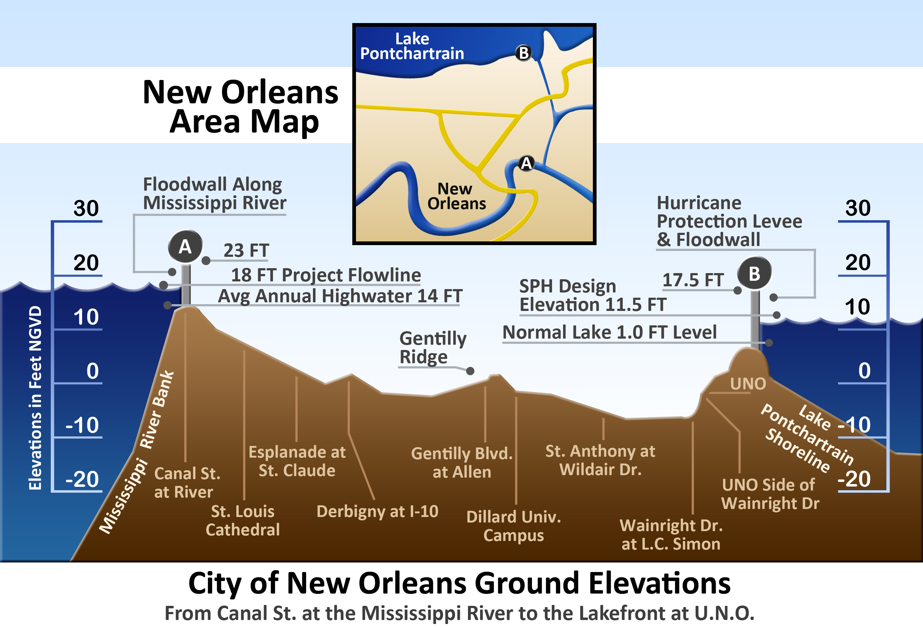
 Vertical cross-section of New Orleans, showing maximum levee height of 23 feet (7 m) at the Mississippi River on the left and 17.5 feet (5 m) at Lake Pontchartrain on the right
The original residents of Greater New Orleans settled on the high ground along the Mississippi River. Later developments eventually extended to nearby Lake Pontchartrain, built upon fill to bring them above the average lake level. Navigable commercial waterways extended from the lake to downtown. After 1940, the state decided to close those waterways following the completion of a new Industrial Canal for waterborne commerce. Closure of the waterways resulted in a drastic lowering of the water table by the city's drainage system, causing some areas to settle by up to 8 feet (2 m) due to the consolidation of the underlying organic soils. After 1965, the Corps of Engineers built a levee system around a much larger geographic footprint that included previous marshland and swamp. The average elevation of the city is between 1 and 2 feet (0.61 m) below sea level. There are no residential areas of the city that are currently more than 10 feet (3 m) below sea level.
After the Great Mississippi Flood of 1927, the Congress mandated the Corps of Engineers as the federal agency responsible for design and construction of flood protection projects, to include those in Greater New Orleans. It also affirmed the principle of local participation in federally funded projects but acknowledged that the $292 million already spent by local interests was sufficient to cover local participatory costs.[2] It also required that local interests had to agree to be responsible for maintenance of any proposed levees before the projects would be initiated.
The heavy flooding caused by Hurricane Betsy in 1965 brought concerns regarding flooding from hurricanes to the forefront. That year, through enactment of the Flood Control Act of 1965 (FCA 1965) Congress authorized the Pontchartrain Hurricane Protection Project. FCA 1965 reiterated the principle of local participation in federally funded projects. The local interests' role was maintenance once the work was complete. Although federally authorized, it was a joint federal, state, and local effort.[3] Almost from the start, the design was impacted by changes due to technical issues, environmental concerns, legal challenges, and local opposition by those opposed to the project.[3] The project was initially estimated to take 13 years, but when Katrina struck in 2005, almost 40 years later, the project was only 60–90% complete with a revised projected completion date of 2015.[citation needed]
On August 29, 2005, flood walls and levees catastrophically failed throughout the metro area. Some – the extent of which is disputed – collapsed well below design thresholds (17th Street and London Canals). Others collapsed after a brief period of overtopping (Industrial Canal) caused "scouring" or erosion of the earthen levee walls – a design flaw. In April 2007, the American Society of Civil Engineers called the flooding of New Orleans "the worst engineering catastrophe in US History."[4]
Levee and floodwall breaches
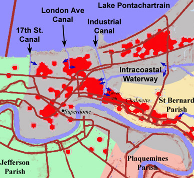
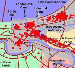 Sketch of New Orleans (shaded grey), indicating the locations of the principal breaches in the levees/floodwalls (dark blue arrows). Red dots show locations of deaths.
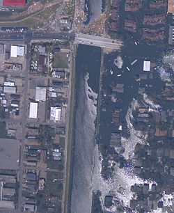 Breach in 17th Street Canal levee in New Orleans, Louisiana, on August 31, 2005, showing the inundated Lakeview neighborhood on the right and the largely dry Metairie side on the left.. (NOAA)
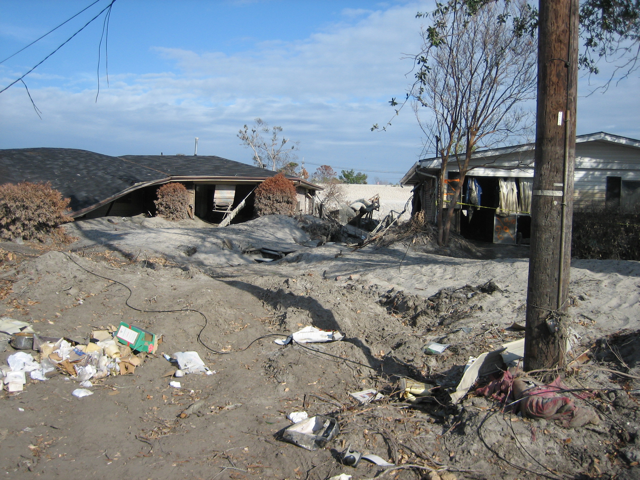
 Severely damaged homes in piles of sand near the upper London Avenue Canal breach
Many of the Corps of Engineers-built levee failures were reported on Monday, August 29, 2005, at various times throughout the day. There were 28 reported levee failures in the first 24 hours[5] and over 50 were reported in the ensuing days. A breach in the Industrial Canal, near the St. Bernard/Orleans parish line, occurred at approximately 9:00 am CDT, the day Katrina hit. Another breach in the Industrial Canal was reported a few minutes later at Tennessee Street, as well as multiple failures in the levee system, and a pump failure in the Lower Ninth Ward, near Florida Avenue.
Local fire officials reported a breach at the 17th Street Canal levee shortly after 9:00 am CDT.[6] An estimated 66% to 75% of the city was now under water.[5] The Duncan and Bonnabel Pumping Stations were also reported to have suffered roof damage, and were non-functional.[5]
Breaches at St. Bernard and the Lower Ninth Ward were reported at 5:00 pm CDT, as well as a breach at the Hayne Blvd. Pumping Station, and another breach along the 17th Street Canal levee.
By 8:30 pm CDT, all pumping stations in Jefferson and Orleans parishes were reported as non-functional.
At 10:00 pm CDT, a breach of the levee on the west bank of the Industrial Canal was reported, bringing 10 feet (3.0 m) of standing water to the area.
At about midnight, a breach in the London Avenue Canal levee was reported.
The Orleans Canal about midway between the 17th Street Canal and the London Avenue Canal, engineered to the same standards, and presumably put under similar stress during the hurricane, survived intact because an incomplete section of floodwall along this canal allowed water to overtop at that point, thus creating a spill way.
Investigations
Levee investigations
In the five years following Katrina over a dozen investigations were carried out. The only federally ordered study was convened and managed by the Corps of Engineers, the federal agency responsible for the flood protection's performance. A major independent study was conducted by the University of California at Berkeley.[7] A second major study was sponsored by the Louisiana Department of Transportation led by Ivor van Heerden at Louisiana State University.[8] Studies were also done by FEMA, the insurance industry, the National Research Council, the National Institute of Standards and Technology, and the Katrina Consolidated Lawsuit. All studies basically agreed on the engineering mechanisms of failure.
The primary mechanisms of failure at the 17th Street Canal, London Avenue Canal and Industrial Canal (east side north) were improper design.[9] The failure mechanism for the Industrial Canal (east side south and west side) was overtopping of levees and floodwalls by the storm surge. The primary mechanism of failure for levees protecting eastern New Orleans was the existence of sand in 10% of places instead of thick Louisiana clay. The primary mechanism of failure for the levees protecting St. Bernard Parish was overtopping due to negligent maintenance[10] of the Mississippi River Gulf Outlet, a navigation channel, by the Army Corps of Engineers.
A June 2006 report by the American Society of Civil Engineers in peer review panel concluded that the flooding in the Lakeview neighborhood (from the 17th Street Canal) and the Gentilly neighborhood (from the London Avenue Canal) was due to two engineering oversights.
The engineers responsible for the design of the canal levees and the I-walls embedded in them over-estimated the soil strength, meaning that the soil strength used in the design calculations was greater than what actually existed under and near the levee during Hurricane Katrina. They made an unconservative (i.e., erring toward unsafe) interpretations of the data: the soil below the levee was actually weaker than that used in the I-wall design (ASCE: External Review Panel, pg 48). Another critical engineering oversight that led to the failure of the 17th Street Canal involves not taking into account the possibility of a water-filled gap which turned out to be a very important aspect of the failures of the I-walls around New Orleans. “Analysis indicate that, with the presence of a water-filled gap, the factor of safety is about 30 percent lower. Because a factor of safety of 1.3 was used for design, a reduction of 30 percent would reduce the factor of safety to approximately one: a condition of incipient failure.” (ASCE: External Review Panel, pg 51)[11]
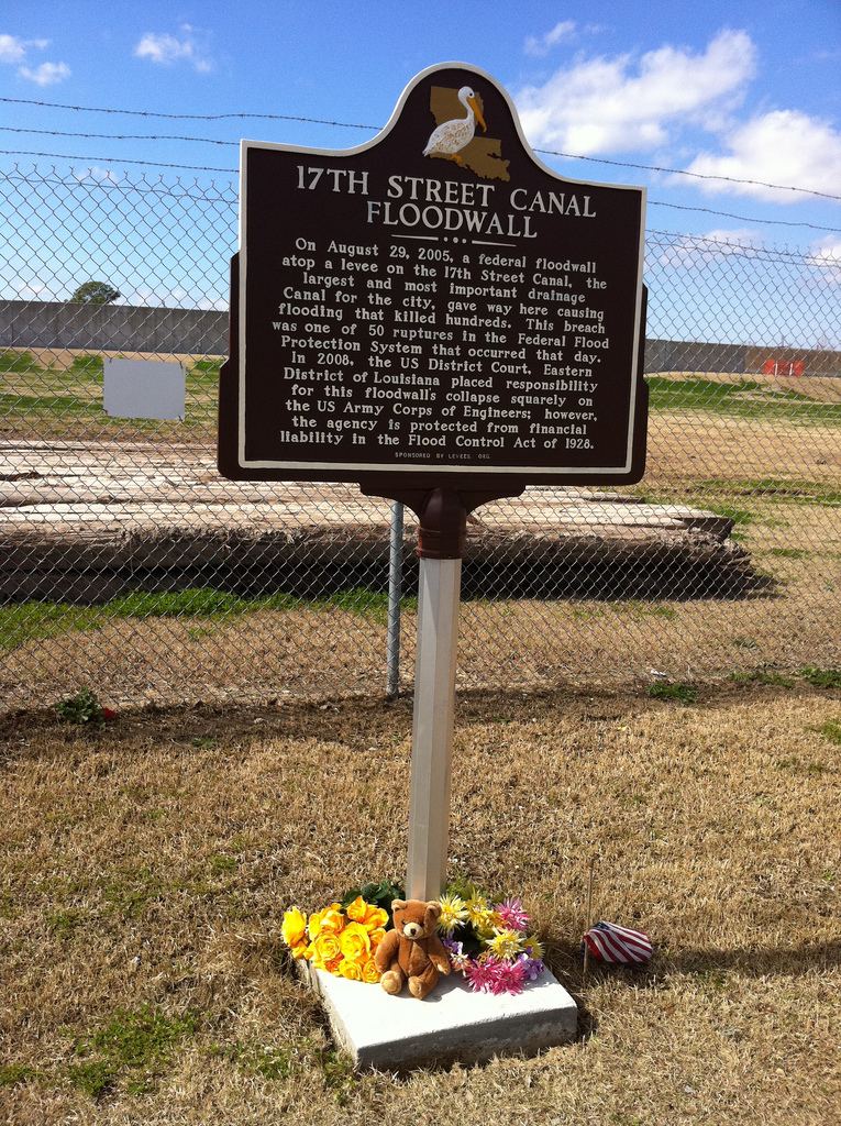
 Louisiana Historic Plaque at 17th Street Canal Breach Site
Soil borings in the area of the 17th Street Canal breach showed a layer of peat starting at about 30 feet (9.1 m) below the surface, and ranging from about 5 feet (1.5 m) to 20 feet (6.1 m) thick. Engineers misjudged the strength of the peat which is from the remains of the swamp on which some areas of New Orleans (near Lake Ponchartrain) in the 20th century were built.[12] The shear strength of this peat was found to be very low and it had a high water content. According to Robert Bea, a geotechnical engineer from the University of California, Berkeley, the weak soil made the floodwall very vulnerable to the stresses of a large flood. "At 17th Street, the soil moved laterally, pushing entire wall sections with it. ... As Katrina's storm surge filled the canal, water pressure rose in the soil underneath the wall and in the peat layer. Water moved through the soil underneath the base of the wall. When the rising pressure and moving water overcame the soil's strength, it suddenly shifted, taking surrounding material – and the wall – with it."[13]
The Federal study was initiated in October 2005, by Lt. Gen. Carl Strock, Chief of Engineers and the Commander of the Corps of Engineers; he established the Interagency Performance Evaluation Task Force (IPET) to "provide credible and objective scientific and engineering answers to fundamental questions about the performance of the hurricane protection and flood damage reduction system in the New Orleans metropolitan area.[14] IPET consisted of independent and recognized experts from the Universities of Maryland, Florida, Notre Dame, and Virginia Polytechnic Institute, the National Oceanic and Atmospheric Administration, the South Florida Water Management District, Harris County Flood Control District (Houston, TX), the United States Department of Agriculture, and the United States Bureau of Reclamation as well as those from USACE.[14]
IPET's final findings indicated that,
With the exception of four foundation design failures, all of the major breaches were caused by overtopping and subsequent erosion. Reduced protective elevations increased the amount of overtopping, erosion, and subsequent flooding, particularly in Orleans East. Ironically, the structures that ultimately breached performed as designed, providing protection until overtopping occurred and then becoming vulnerable to catastrophic breaching. The levee-floodwall designs for the 17th Street and London Avenue Outfall Canals and IHNC were inadequate for the complex and challenging environment. In four cases the structures failed catastrophically prior to water reaching design elevations. A significant number of structures that were subjected to water levels beyond their design limits performed well. Typically, in the case of floodwalls, they represented more conservative design assumptions and, for levees, use of higher quality, less erodible materials.[14]The levee-floodwall designs for the 17th Street and London Avenue Outfall Canals and IHNC were completely inadequate and "designed for failure" according to Dr. Ivor van Heerden, leader of the Team Louisiana investigation. The levees failed catastrophically five feet below design specifications. Levees that were, on-average two feet too low, increased the amount of overtopping, erosion, and subsequent flooding, particularly in eastern New Orleans. A significant number of structures that were subjected to water levels beyond their design limits performed well. Typically, in the case of floodwalls, they represented more conservative design assumptions and, for levees, use of higher quality, less erodible materials.[14]}}
Criticism of Federal Investigation (IPET)
The IPET's findings are challenged by Levees.org[15] (a grass roots organization) as lacking credibility since the USACE convened and managed the study and also chose and directly compensated its peer review team. The groups points out that eighty percent of the participants in IPET either worked for the Corps of Engineers or its sister agency Army Research and Development. The top three leaders all were Corps employees.
The credibility of the IPET was also challenged in a 42-page letter to the American Society of Engineers submitted by Dr. Ray M. Seed, co-chair of the ILIT study. Dr. Seed described an early intentional plan by the Corps of Engineers to hide their mistakes in the New Orleans flooding after Katrina and to intimidate anyone who tried to intervene. All of this was done with the help and the complicity of some at the ASCE, according to Dr. Seed.[16]
Flood wall design
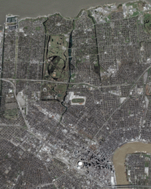 Satellite photos of New Orleans taken in March 2004, then on August 31, 2005, after the levee failures.
Investigators focused on the 17th Street and London Avenue canals, where evidence showed they were breached even though water did not flow over their tops, indicating a design or construction flaw. Eyewitness accounts and other evidence show that levees and flood walls in other parts of the city, such as along the Industrial Canal, were topped by floodwaters first, then breached or eroded. Many New Orleans levee and flood wall failures in the wake of Hurricane Katrina occurred at weak-link junctions where different levee or wall sections joined together, according to a preliminary report released on November 2, 2005, carried out by independent investigators from the University of California, Berkeley and the American Society of Civil Engineers (ASCE).[17][18]
The original design for the steel sheet foundations for the flood walls showed a proposed depth of 10 feet (3 m), and design documents show that calculations were made with the wall base at 12.8 feet (3.9 m). According to a New Orleans engineer, the depth was apparently later increased to 17 feet (5.2 m), and this is what was built. However, a forensic engineering team from the Louisiana State University, using sonar, showed that at one point near the 17th Street Canal breach, the piling extends just 10 feet (3.0 m) below sea level, 7 feet (2.1 m) shallower than the Corps of Engineers had maintained. "The Corps keeps saying the piles were 17 feet, but their own drawings show them to be 10 feet, Ivor van Heerden said. "This is the first time anyone has been able to get a firm fix on what's really down there. And, so far, it's just 10 feet. Not nearly deep enough."[19] Other reports confirmed that construction on the London Avenue and Industrial Canal levees was similarly below the stated standard.[20] They also found that homeowners along the 17th Street Canal, near the site of the breach, had been reporting their yards flooding from persistent seepage from the canal for a year prior to Hurricane Katrina. Other studies showed the levee floodwalls on the 17th Street Canal were, "destined to fail,", from bad Corps of Engineers design, saying in part, "that miscalculation was so obvious and fundamental," investigators said, they, "could not fathom how the design team of engineers from the Corps, local firm Eustis Engineering, and the national firm Modjeski and Masters could have missed what is being termed the costliest engineering mistake in American history."[20]
Dr. Robert Bea, chair of an independent levee investigation team, has said that the New Orleans-based design firm Modjeski and Masters could have followed correct procedures in calculating safety factors for the flood walls. He added, however, that design procedures of the Corps may not account for changes in soil strength caused by the changes in water flow and pressure during a hurricane flood.[21] Dr. Bea has also questioned the size of the design safety margins. He said the corps applied a 30% margin over the maximum design load. A doubling of strength would be a more typical margin for highway bridges, dams, off-shore oil platforms and other public structures. There were also indications that substandard concrete may have been used at the 17th Street Canal.
The two sets of November tests conducted by the Corps of Engineers and LSU researchers used non-invasive seismic methods. Both studies understated the length of the piles by about seven feet. By December, seven of the actual piles had been pulled from the ground and measured. The Engineering News Record reported on December 16 that they ranged from 23' 3 1/8" to 23' 7 7/16" long, well within the original design specifications, contradicting the early report of short pilings. The suitability of the original design specifications, however, continues to be contested.
In August 2007, the Corps released an analysis revealing that their floodwalls were so poorly designed that the maximum safe load is only 7 feet (2.1 m) of water, which is half the original 14-foot (4.3 m) design.[22]
Overtopping of levees in the Eastern New Orleans
According to Professor Raymond Seed of the University of California, Berkeley, a surge of water estimated at 24 feet (7 m), about 10 feet (3 m) higher than the height of the levees along the city's eastern flank, swept into New Orleans from the Gulf of Mexico, causing most of the flooding in the city. He said that storm surge from Lake Borgne travelling up the Intracoastal Waterway caused the breaches on the Industrial Canal.[23]
Aerial evaluation revealed damage to approximately 90% of some levee systems in the east which should have protected St. Bernard Parish.
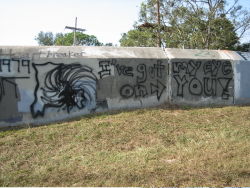 Portion of the flood wall atop 17th Street Canal levee, with Katrina-related graffiti. Notice cracks in the flood wall joints. Maintenance and inspection are the responsibility of local levee boards as mandated by the Flood Control Act of 1928
National Academy of Sciences Investigation
On October 19, 2005, Defense Secretary Donald Rumsfeld announced that an independent panel of experts, under the direction of the National Academy of Sciences, would convene to evaluate the performance of the New Orleans levee system, and issue a final report in eight months. The panel would study the results provided by the two existing teams of experts that had already examined the levee failures.[24]
Senate Committee hearings
Preliminary investigations and evidence were presented before the U.S. Senate Committee on Homeland Security and Governmental Affairs on November 2, 2005, and generally confirmed the findings of the preliminary investigations.[25]
On November 9, 2005, The Government Accountability Office testified before the Senate Committee on Environment and Public Works. The report cited the Flood Control Act of 1965, which authorized the U.S. Army Corps of Engineers to design and construct a flood protection system to protect south Louisiana from the strongest storms characteristic of the region.
Corps of Engineers admits problems with design
On April 5, 2006, months after independent investigators had demonstrated that the levee failures were not due to natural forces beyond intended design strength, Lt. Gen. Carl Strock testified before the U.S. Senate Subcommittee on Energy and Water that, "We have now concluded we had problems with the design of the structure." He also testified that the U.S. Army Corps of Engineers did not know of this mechanism of failure prior to August 29, 2005. The claim of ignorance is refuted, however, by the National Science Foundation investigators hired by the Army Corps of Engineers, who point to a 1986 study by the corps itself that such separations were possible in the I-wall design.[26]
Nearly two months later, on June 1, 2006, the USACE finalized their report. The final draft of the IPET report states the destructive forces of Katrina were "aided by incomplete protection, lower than authorized structures, and levee sections with erodible materials."[citation needed] The reasons that particular decisions were made concerning incomplete protection, lower structures, and erodible materials were used remains in dispute.[citation needed]
Conspiracy theories
Nation of Islam leader Louis Farrakhan among other public figures claimed the levees were dynamited to divert waters away from wealthy white areas. The conspiracy theory reached a United States House of Representatives committee investigating Katrina when a New Orleans community activist made the claim. The theory became according to the New Orleans Times Picayune an "urban myth". Reasons for belief in these theories were ascribed to the decision by city officials during The Great Mississippi Flood of 1927 to set off 30 tons of dynamite on the levee at Caernarvon, Louisiana which eased pressure on levees at New Orleans but flooded St. Bernard Parish, the Ninth Ward taking the brunt of the city's flooding during Hurricane Betsy, the general disenfranchisement of blacks and lower class people, and the similarity of sound of the levees collapsing to that of a bombing.[27][28][29]
See also
- Flood Control Act of 1965
- 17th Street Canal
- Civil engineering and infrastructure repair in New Orleans after Hurricane Katrina
- Drainage in New Orleans
- Industrial Canal
- ING 4727
- Old River Control Structure
- Seabrook Floodgate
- London Avenue Canal
- U.S. Army Corps of Engineers civil works controversies (New Orleans)
References
- ^ http://www.gao.gov/new.items/d051050t.pdf
- ^ Flood Control Act of 1928 on Mississippi Valley Division of USACE website
- ^ a b GAO Report on Lake Pontchartrain and Vicinity Hurricane Protection Project, September 2005
- ^ The New Orleans Levees: The Worst Engineering Catastrophe in US History - What Went Wrong and Why
- ^ a b c Staff Writer. "Timeline: Who Knew When the Levees Broke." National Public Radio. February 10, 2006.
- ^ News for New Orleans, Louisiana | Local News | News for New Orleans, Louisiana | wwltv.com
- ^ ILIT DOWNLOAD CENTER (sponsored in part by the National Science Foundation)
- ^ LSU Katrina Investigation
- ^ http://www.dotd.louisiana.gov/administration/teamlouisiana/
- ^ http://www.nola.com/hurricane/index.ssf/2009/11/post_16.html
- ^ http://levees.org/2/wp-content/uploads/2010/06/American-Society-of-Civil-Engineers-What-Went-Wrong-ERPreport-1.pdf
- ^ McQuaid, John; Marshall, Bob. "Officials knew about weak soil under levee." Times Picayune. October 22, 2005.
- ^ McQuaid, John. "Swamp peat was poor anchor, engineer says." Times Picayune. October 15, 2005.
- ^ a b c d IPET Final Draft Report
- ^ http://levees.org/
- ^ http://www.lasce.org/documents/RaySeedsLetter.pdf
- ^ Yang, Sarah. "Investigators release preliminary findings of levee failures at Senate hearing." University of California, Berkeley. November 2, 2005.
- ^ Seed, R.B.; et al. "Preliminary Report on the Performance of the New Orleans Levee Systems in Hurricane Katrina on August 29, 2005." University of California, Berkeley. November 2, 2005.
- ^ Marshall, Bob. "Short Sheeted." Times Picayune. November 10, 2005.
- ^ a b Marshall, Bob. "17th Street Canal levee was doomed." Times Picayune. November 30, 2005.
- ^ "Investigation of the Performance of the New Orleans Flood Protection Systems in Hurricane Katrina on August 29, 2005". Independent Levee Investigation Team Final Report. July 31, 2006
- ^ Corps analysis shows canal's weaknesses - Breaking News Updates New Orleans - Times-Picayune - NOLA.com
- ^ Seed, Raymond B. "Hurricane Katrina: Performance of the Flood Control System." (Testimony before the Committee on Homeland Security and Government Affairs, U.S. Senate) University of California, Berkeley. November 2, 2005.
- ^ Schleifstein, Mark. "Corps levee probe role reduced." Times Picayune. October 19, 2005.
- ^ "Hurricane Katrina: Why Did the Levees Fail?." U.S. Senate (Hearing Report for the Committee on Homeland Security and Governmental Affairs). November 2, 2005.
- ^ Walsh, Bill. "Corps chief admits to 'design failure'." Times Picayune. April 6, 2006.
- ^ Rumor of levee dynamite persists New Orleans Times Picayune December 12, 2005
- ^ Manning Marable, Kristen Clarke, Seeking Higher Ground: The Hurricane Katrina Crisis, Race, and Public Policy (2008), p. 192. ISBN 1-4039-7779-8.
- ^ Eve Zibart, Tom Fitzmorris, Will Coviello, The Unofficial Guide to New Orleans (2009), p. 23.
Further reading
- van Heerden, Ivor; Bryan, Mike (2006). What Went Wrong and Why During Hurricane Katrina. Viking. ISBN 0-670-03781-8.
External links
- Levees.Org (non-profit flood protection group in New Orleans)
- [https://ipet.wes.army.mil/ Interagency Performance Evaluation Taskforce (IPET) Draft Final Report] (1 June 2006) provided by USACE
Note: Site may be slow to load and considered non-secure by IE7 - IPET Draft Final Report (1 June 2006) provided by The Times-Picayune
- YouTube video Eyewitness recreation and plot of explosions seen in the vicinity of the Industrial Canal. Posted by creator/copyright holder of video. Reproduction of video is granted and encouraged.
- Independent Levee Investigation Team (ILIT) Final Report (31 July 2006)
* Hurricane Katrina External Review Panel Report
Hurricane Katrina 
Timeline | Meteorological history | Tornado outbreak | Preparations | New Orleans preparations | Economic effects | Political effects | Criticism | Social effects | Human rights Effects by region | Mississippi | New Orleans | Florida | Levee failures | Infrastructural repair | Reconstruction Disaster relief | International response | Historical context | Media coverage Coordinates: 29°57′53″N 90°04′14″W / 29.964722°N -90.070556°E
Categories:- Structures affected by Hurricane Katrina
- George W. Bush administration controversies
- Dikes in the United States


Wikimedia Foundation. 2010.