- Meteorological history of Hurricane Katrina
-
Hurricane Katrina Category 5 Hurricane (SSHS)
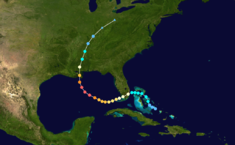
Hurricane Katrina track mapFormed August 23, 2005 Dissipated August 30, 2005 Highest
winds175 mph (280 km/h) (1-minute sustained) Lowest pressure 902 mbar (hPa; 26.65 inHg) Areas affected Bahamas, South Florida, Cuba, Louisiana (especially Greater New Orleans), Mississippi, Alabama, Florida Panhandle, most of eastern North America Part of the
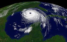
2005 Atlantic hurricane seasonThe meteorological history of Hurricane Katrina, an extremely destructive Category 5 hurricane, began on August 23, 2005 when it originated as Tropical Depression Twelve near the Bahamas. The next day, the tropical depression strengthened to a tropical storm, and was named Katrina; it proceeded to make landfall on the southern tip of the U.S. state of Florida as a minimal hurricane.
In passing across Florida, Katrina weakened to a tropical storm; however, the warm waters of the Gulf of Mexico allowed it to rapidly intensify to the sixth strongest Atlantic hurricane in recorded history. Afterward, Katrina made landfall as a Category 3 storm near Buras-Triumph, Louisiana, and once more near the Mississippi/Louisiana border. Katrina progressed northward through the central United States and finally dissipated near the Great Lakes, when it was absorbed by a cold front.
Contents
Formation
Hurricane Katrina 
2005 Atlantic hurricane season General - Timeline
- Meteorological history
- Tornado outbreak
- Preparations
Impact Relief Analysis - Global warming
- Historical context
- Media coverage
External links  Media related to Hurricane Katrina at Wikimedia Commons
 News related to Katrina stories at Wikinews
 Works related to Katrina sources at Wikisource
Listen to this article (info/dl)
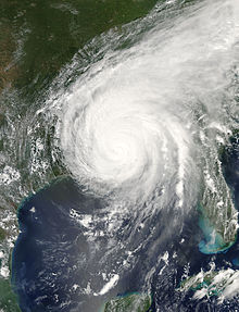
Satellite imagery of Hurricane Katrina making landfall.
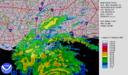
Katrina made its second landfall at 6:10 a.m. CDT on August 29 as a Category 3 hurricane with sustained winds of 125 mph (205 km/h) near Buras-Triumph, Louisiana. Because Katrina had just weakened from Category 4 and due to the shape of the coastline, sustained Category 4 winds likely existed on land while the eye was over water. At landfall, hurricane-force winds extended 120 miles (190 km) from the center, the storm's pressure was 920 mbar (27.17 inHg), and its forward speed was 15 mph (24 km/h). As it made its way up the eastern Louisiana coastline, most communities in Plaquemines, St. Bernard Parish, and Slidell in St. Tammany Parish were severely damaged by storm surge and the strong winds of the eyewall, which also grazed eastern New Orleans, causing in excess of $1 billion worth of damage to the city (see Effect of Hurricane Katrina on New Orleans).
Original estimates indicated that Katrina had made this landfall as a Category 4 hurricane, with 135 mph (220 km/h) winds;[10] however, as indicated above, the storm weakened just before landfall to Category 3 intensity. The reasons for this weakening are not completely known yet; while the eye-wall replacement cycle played a part, slightly increasing shear, dropping sea-surface temperatures, dry air on the western semicircle of the storm and interaction with the continental landmass also may have played a role in weakening the cyclone.[2] This follows the trend of previous strong cyclones in the Gulf of Mexico: all cyclones with minimum central pressures of 973 mbar (28.73 inHg) or less have weakened over the 12 hours before making landfall in the Gulf Coast of the United States.[2]
A few hours later, after weakening slightly, Katrina made its third landfall near the Louisiana–Mississippi border with 120 mph (195 km/h) sustained winds and 928 mbar (27.37 inHg) pressure, still at Category 3 intensity. Its minimum pressure at its second landfall was 920 mbar (27.17 inHg), making Katrina the third strongest hurricane on record to make landfall on the United States, behind Hurricane Camille's 909 mbar (26.85 inHg) reading in 1969, and the 1935 Labor Day Hurricane's 892 mbar (26.35 inHg) record.[2]
Because the storm was so large, highly destructive eye-wall winds and the strong northeastern quadrant of the storm pushed record storm surges onshore, smashing the entire Mississippi Gulf Coast, including towns in Mississippi such as Waveland, Bay St. Louis, Pass Christian, Long Beach, Gulfport, Biloxi, Ocean Springs, Gautier and Pascagoula, and, in Alabama, Bayou La Batre. The surges peaked at 28 feet (8.5 m) in Bay St. Louis, Mississippi, and at 13 feet (4.0 m) as far away as Mobile, Alabama, which saw its highest storm surge since 1917.[2] Storm surge was particularly high due to the hydrology of the region, the hurricane's extreme size, and the fact that it weakened only shortly before landfall. As Katrina moved inland diagonally over Mississippi, high winds cut a swath of damage that affected almost the entire state.[2]
Demise
Katrina maintained hurricane strength well into Mississippi, but weakened thereafter, losing hurricane strength more than 150 miles (240 km) inland, near Meridian, Mississippi. It was downgraded to a tropical depression near Clarksville, Tennessee and broke in half.[11] One half continued to race northward, affecting the Central United States along its path, and was last distinguishable in the eastern Great Lakes region on August 31. On August 31, Katrina was absorbed by a frontal boundary and became a powerful extratropical low, causing 1.97–6.69 inches (50–170 mm) of rain in 12 hours, as well as gale-force wind gusts from 31 to 61 mph (50 to 98 km/h) in southeastern Quebec and northern New Brunswick. In the region of Saguenay and Côte-Nord, rain caused breakdowns and failure in roads. The Côte-Nord region was isolated from the rest of Quebec for at least 1 week. The other half of Katrina broke off in the eastern part of the Appalachians, primarily leading to a significant tornado outbreak in the area from central Georgia to central Pennsylvania, killing two people and causing millions of dollars in additional damage.[2]
At 11:00 p.m. EDT on August 31, the center of the remnant low of what was Katrina had been completely absorbed by a frontal boundary in southeastern Canada, with no discernible circulation.[12][13]
See also
- Hurricane Katrina tornado outbreak
- Risk prevention
- Timeline of Hurricane Katrina
References
- ^ Stewart, Stacy (August 23, 2005). "Tropical Depression Twelve, Discussion No. 1, 5:00 p.m. EDT". National Hurricane Center. http://www.nhc.noaa.gov/archive/2005/dis/al122005.discus.001.shtml. Retrieved 2006-09-16.
- ^ a b c d e f g h i j k l Knabb, Richard D.; Rhome, Jamie R. "Tropical Cyclone Report: Hurricane Katrina." National Hurricane Center. December 20, 2005.
- ^ Stewart, Stacy (August 24, 2005). "Tropical Storm Katrina Discussion No. 5, 5:00 p.m. EDT". National Hurricane Center. http://www.nhc.noaa.gov/archive/2005/dis/al122005.discus.005.shtml?. Retrieved 2006-09-16.
- ^ Stewart, Stacy (August 26, 2005). "Hurricane Katrina Discussion No. 14, 5:00 p.m. EDT". National Hurricane Center. http://www.nhc.noaa.gov/archive/2005/dis/al122005.discus.014.shtml?. Retrieved 2006-09-16.
- ^ Knabb, Richard (August 27, 2005). "Hurricane Katrina Advisory No. 16, 5:00 a.m. EDT". National Hurricane Center. http://www.nhc.noaa.gov/archive/2005/pub/al122005.public.016.shtml?. Retrieved 2006-09-16.
- ^ Knabb, Richard (August 28, 2005). "Hurricane Katrina Advisory No. 20, 1:00 a.m. CDT". National Hurricane Center. http://www.nhc.noaa.gov/archive/2005/pub/al122005.public.020.shtml?. Retrieved 2006-09-16.
- ^ Knabb, Richard; Richard Pasch (August 28, 2005). "Hurricane Katrina Special Advisory No. 20, 7:00 a.m. CDT". National Hurricane Center. http://www.nhc.noaa.gov/archive/2005/pub/al122005.public.022.shtml?. Retrieved 2006-09-16.
- ^ Pasch, Richard (August 28, 2005). "Hurricane Katrina Intermediate Advisory No. 23a, 1:00 p.m. CDT". National Hurricane Center. http://www.nhc.noaa.gov/archive/2005/pub/al122005.public_a.023.shtml?. Retrieved 2006-09-16.
- ^ Pasch, Richard (August 28, 2005). "Hurricane Katrina Advisory No. 24, 4:00 p.m. CDT". National Hurricane Center. http://www.nhc.noaa.gov/archive/2005/pub/al122005.public.024.shtml?. Retrieved 2006-09-16.
- ^ Pasch, Richard (August 29, 2005). "Hurricane Katrina Intermediate Advisory No. 26b, 8:00 a.m. CDT". National Hurricane Center. http://www.nhc.noaa.gov/archive/2005/pub/al122005.public_b.026.shtml?. Retrieved 2006-09-16.
- ^ Avila, Lixion (August 30, 2005). "Tropical Depression Katrina Advisory No. 31, 10 a.m. CDT". National Hurricane Center. http://www.nhc.noaa.gov/archive/2005/pub/al122005.public.031.shtml?. Retrieved 2006-09-16.
- ^ "Public Advisory 37 for the Remnants of Katrina, 11 p.m. EDT". Hydrometeorological Prediction Center. August 31, 2005. http://weather.unisys.com/hurricane/archive/0509/05090100. Retrieved 2006-09-16.
- ^ "Post-Tropical Storm Katrina Information Statement, 08:00 a.m. EDT". Canadian Hurricane Centre. August 31, 2005. http://www.atl.ec.gc.ca/weather/hurricane/bulletins/20050831114442.Katrina.txt.en. Retrieved 2006-09-19.
Hurricane Katrina 
Timeline | Meteorological history | Tornado outbreak | Preparations | New Orleans preparations | Economic effects | Political effects | Criticism | Social effects | Human rights Effects by region | Mississippi | New Orleans | Florida | Levee failures | Infrastructural repair | Reconstruction Disaster relief | International response | Historical context | Media coverage Categories:- Hurricane Katrina
- Meteorological histories of individual tropical cyclones
Wikimedia Foundation. 2010.
Look at other dictionaries:
Meteorological history of Hurricane Wilma — Hurricane Wilma Category 5 hurricane (SSHS) Hurricane Wilma track map Formed October 15, 2005 Dissipated … Wikipedia
Meteorological history of Hurricane Dean — Hurricane Dean Category 5 hurricane (SSHS) Track of Hurricane Dean Formed August 13, 2007 Dissipated … Wikipedia
Meteorological history of Hurricane Ivan — Hurricane Ivan Category 5 hurricane (SSHS) The path of Hurricane Ivan Formed September 2, 2004 Dissipated … Wikipedia
Meteorological history of Hurricane Andrew — Hurricane Andrew Category 5 hurricane (SSHS) The path of Hurricane Andrew Formed August 16, 1992 Dissipated … Wikipedia
Hurricane Katrina tornado outbreak — The Hurricane Katrina tornado outbreak was a tornado outbreak across the eastern United States from August 29 to 31, 2005, spawned mostly by the outer bands of Hurricane Katrina (or the remnants thereof).One person was killed and numerous… … Wikipedia
Timeline of Hurricane Katrina — This article contains a historical timeline of the events of Hurricane Katrina.FormationTuesday, August 23, 2005Tropical Depression Twelve formed over the southeastern Bahamas at 5:00 PM EDT (2100 UTC) on August 23, 2005, partially from the… … Wikipedia
Hurricane Katrina — Infobox Hurricane Name=Hurricane Katrina Type=hurricane Year=2005 Basin=Atl Image location=Hurricane Katrina August 28 2005 NASA.jpg Formed=August 23, 2005 Dissipated=August 30, 2005 1 min winds=150 Pressure=902 Da Inflated=1 Damagespost=… … Wikipedia
Hurricane Katrina disaster relief — For more detailed criticisms of disaster relief, see Political effects of Hurricane Katrina. For a more detailed timeline of events, see Timeline of Hurricane Katrina. Hurricane Katrina … Wikipedia
Hurricane Katrina effects by region — This article covers the Hurricane Katrina effects by region, within the United States and Canada. The effects of Hurricane Katrina, in August 2005, were catastrophic and widespread. It was one of the deadliest natural disasters in U.S. history,… … Wikipedia
Hurricane Katrina (1981) — Infobox Hurricane Name=Hurricane Katrina Image location=Hurricane Katrina of 1981.jpg Type=hurricane Basin=Atl Year=2005 Formed=August 29, 2005 Dissipated=November 8, 1981 1 min winds=75 Pressure=980 Da Fatalities=2 direct Areas=Cuba, Bahamas,… … Wikipedia


