- Orienteering
-
This article is about the sport of orienteering. For the way it is practiced in Scouting and the armed forces, see Orienteering (Scouting)
 The international orienteering symbol
Orienteering is a family of sports that requires navigational skills using a map and compass to navigate from point to point in diverse and usually unfamiliar terrain, and normally moving at speed. Participants are given a topographical map, usually a specially prepared orienteering map, which they use to find control points.[1] Originally a training exercise in land navigation for military officers, orienteering has developed many variations. Among these, the oldest and the most popular is foot orienteering. For the purposes of this article, foot orienteering serves as a point of departure for discussion of all other variations, but basically any sport that involves racing against a clock and requires navigation using a map is a type of orienteering.
Orienteering is included in the programs of world sporting events including the World Games[2] (see Orienteering at the World Games) and World Police and Fire Games.[3]
Contents
Orienteering sports
Orienteering sports combine significant navigation with a specific method of travel. Because the method of travel determines the needed equipment and tactics, each sport requires specific rules for competition and guidelines for orienteering event logistics and course design.
- Foot orienteering
- Mountain bike orienteering
- Ski orienteering
- Trail orienteering
- Radio orienteering (including variants Fox Oring and ROCA)
- Canoe orienteering
- Mounted orienteering
- Rogaining
- SportLabyrinth - micro orienteering
- Mountain marathon
- Car orienteering
Adventure racing is a combination of two or more disciplines, that usually includes orienteering as part of the race.
Governing bodies
International
At international level, the International Orienteering Federation (IOF)[4] defines rules and guidelines[5] which govern four orienteering sports: foot orienteering, mountain bike orienteering, ski orienteering, and trail orienteering.[6] It is based in Finland[7] and it claims on its website to aim to "spread the sport of orienteering, to promote its development and to create and maintain an attractive world event programme."[8] Since 1977 the IOF has been recognised by the IOC[9]
National
See also: International Orienteering Federation MembersThere are governing bodies for most of the individual nations that are represented in the sport of orienteering. These national bodies are the rule-making body for that nation. For example the British Orienteering Federation is the national governing body for the United Kingdom. The federation was founded in 1967 and it is made up of 13 constituent associations.[10]
Regional
Most nations have some form of regional governing bodies. These are not rule-making bodies but are there to assist in coordinating clubs within that region, e.g., they may allocate dates so that clubs do not clash with their events.
Local
See also: Orienteering clubsClubs are usually formed at a local level and affiliated to their national governing body. It is clubs who put on events usually open to all-comers. Clubs may also put on practice, training, and social events. Open clubs are open to anyone and there is usually no restriction on joining them. Closed clubs restrict their membership to specific groups. For example BAOC (British Army Orienteering Club)[11] has restrictions on who may join, principally British Army personnel.
Related sports
- The International Rogaining Federation governs rogaining.[12]
- Separate organizations govern competitive mounted orienteering in the United States and Europe (and the two sports are dissimilar).
- The International Amateur Radio Union governs amateur radio direction finding. [13]
Terminology (variants)
Orienteering terms vary within English speaking countries, and in other countries where English is the de facto international language of orienteering. Variations are set out in table below.
IOF UK US event meet competition race control description list control description sheet clue sheet [control] flag banner/flag/kite [course] planner [course] setter [event] controller [event] checker History
The history of orienteering begins in the late 19th century in Sweden, the actual term "orienteering" was first used in 1886 and meant the crossing of unknown land with the aid of a map and a compass.[14] In Sweden, orienteering grew from military training in land navigation into a competitive sport for military officers, then for civilians. The first orienteering competition open to the public was held in Norway in 1897.[14]
From the beginning, locations selected for orienteering have been chosen in part for their beauty, natural or man made. For the first public orienteering competition in Sweden, in 1901, control points included two historic churches, Spånga kyrka and Bromma kyrka (a round church).[15]
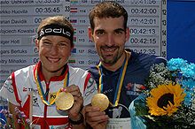 World Orienteering Championships 2007 in Kiev, Ukraine. Winners of middle-distance event: Simone Niggli-Luder, Switzerland, and Thierry Gueorgiou, France
With the invention of inexpensive yet reliable compasses, the sport gained popularity during the 1930s. By 1934, over a quarter million Swedes were participants, and orienteering had spread to Finland, Switzerland, the Soviet Union, and Hungary. Following World War II, orienteering spread throughout Europe and to Asia, North America and Oceania. In Sweden in 1959, an international orienteering conference was held. Representatives from 12 countries (Austria, Bulgaria, Czechoslovakia, Denmark, Finland, East and West Germany, Hungary, Norway, Sweden, Switzerland, Yugoslavia) participated.[14] In 1961, orienteering organizations representing 10 European nations founded the International Orienteering Federation (IOF). Since then, IOF has supported the founding of many national orienteering federations. By 2010, 71 national orienteering federations were member societies of the International Orienteering Federation.[16] These federations enabled the development of national and world championships. World championships were held every two years until 2003, then every year.[17]
Throughout this time, orienteering has remained most popular in Scandinavia. There, the two oldest recurring orienteering meets have been held since the 1940s (Jukola relay and Tiomila), and the single largest orienteering meet has been held every year since 1965 and attracts around 15,000 competitors (O-Ringen).[18]
Competition and results
Basics
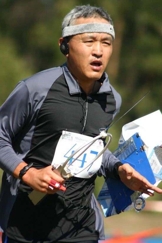
 An orienteer at a control point
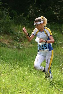 An orienteer navigates while running
The competition, or race, is intended to test 'the navigational skill, concentration, and running ability of the competitors'. High levels of fitness and running speed are required to compete successfully at an international or elite level. To ensure fairness between competitors the map is not usually provided until the start, and starts are normally staggered with competitors starting at not less than one-minute intervals.[19]
The objective on each leg is to follow the fastest route between controls. The fastest is not always the shortest route, and can depend heavily on route choice. [20]
Map
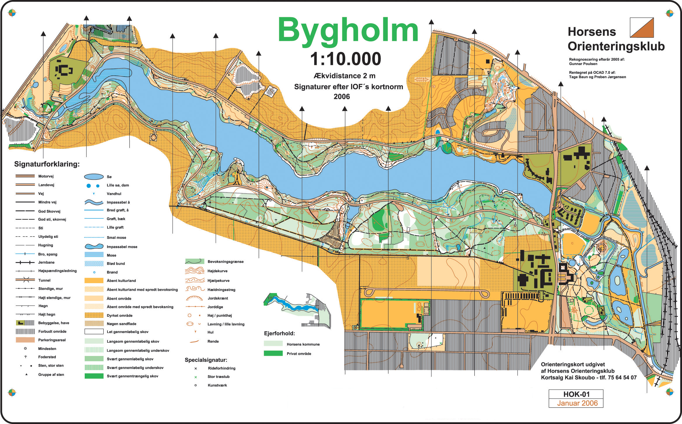
 An orienteering map
Orienteering competitions use specially prepared orienteering maps. They are topographic maps although much more detailed than general-purpose maps. The ISOM map scales are 1:15,000 or 1:10,000, with grids aligned to magnetic north. Map symbols are standardized by the IOF,[21] and designed to be readable by any competitor no matter his background or native tongue.
Courses
 An example of how control points are shown on an orienteering map
Orienteering events offer a range of courses, of varying physical and technical difficulty, to meet the needs of competitors. The orienteering course is marked in purple or red on a map.[22] A triangle is used to indicate the start and a double circle indicates the finish. Circles are used to show the control points.[23]
At international, national, and the larger events courses are classified by age, e.g., M35 for men 35 years of age and older. Classes requiring similar distances are usually combined into a smaller number of courses, e.g., M60 will normally share a course with W50, and often with M65 and W55. The results are normally arranged by class.[24]
Ability based courses
In the smaller events courses are provided by ability. The United States[23][25] and the United Kingdom, use colour-coded courses to define the difficulty of the courses. Short, easy courses are provided for beginners and the younger competitors, with technically and physically demanding courses being provided for the experienced orienteers.[26]
Permanent courses and other events
Some orienteering clubs have set up permanent courses, which can be used for personal, or club, training. Non-standard permanent markers are used as control kites, and maps of the courses are usually available publicly for a fee.[27] The courses are usually set up in public areas and there may be some restrictions on access, e.g., daylight hours only. Clubs also organise informal events for practice and training.[28]
Controls and control description sheet
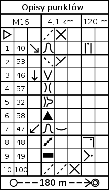 Control description sheet (pictorial)
Control points are placed on features on the map that can be clearly identified on the ground. Control points are marked in the terrain by white and orange "flags".
Competitors receive a "control description sheet" or "clue sheet" which gives a precise description of the feature and the location of the kite, e.g., boulder, 5m, north side. For experienced orienteers the descriptions use symbols (pictorial), in accordance with the IOF Control descriptions.[29]
Control card and punching
Each competitor is required to carry a control card, and to present it at the Start and hand it in at the Finish. The control card is marked by some means at each control point to show that the competitor has completed the course correctly. Most events now use electronic punching, although cards and needle punches are still widely used.[30]
Results
The winner is normally the competitor with the fastest time, but other scoring systems can be used, e.g., score events and Trail-O. Most events produce provisional results 'on the day', with draft results on the Internet that night; the final results being confirmed a few days later. With electronic punching[31] the results can include split times for competitors. These show the times between controls and aggregate times to each control. With suitable computer software these times can be displayed in a graphical form (Progressograph).[32]
Safety
Each competitor is responsible for his own safety. There are no rules, but there are guidelines, which should be followed. The basic safety check was the stub check. The competitor hands in his stub at the start and his control card at the finish. Event officials match the two and any unmatched stubs represent a missing competitor. This has been superseded with electronic punching in that event officials can now request a ‘still to finish’ report listing all those competitors who punched at the start but have not yet downloaded their electronic card. All competitors must report to the finish whether they have completed the course or not.[19][23]
Personal clothing
IOF rule 21.1 is that the specification for clothing is delegated to the national organising body.[33] UK rule 7.1.1 requires full body cover: the torso and legs must be covered.[34] The organiser may allow shorts, e.g., in park or street orienteering.
The early competitors used standard athletic clothing, i.e., shorts and an athletic vest, which provided little protection for racing through undergrowth. Purpose-made lightweight nylon full-body suits were later adopted. The early O-suits were made in muted colours but modern suits are generally multi-coloured. Clubs often organise the bulk purchase of clothing, which are then made in the club colours with the club’s name prominently displayed. Some competitors prefer lycra tights or leggings. Gaiters are also often worn. Lightweight studded (and often cleated) orienteering shoes are commonly used.
Personal equipment
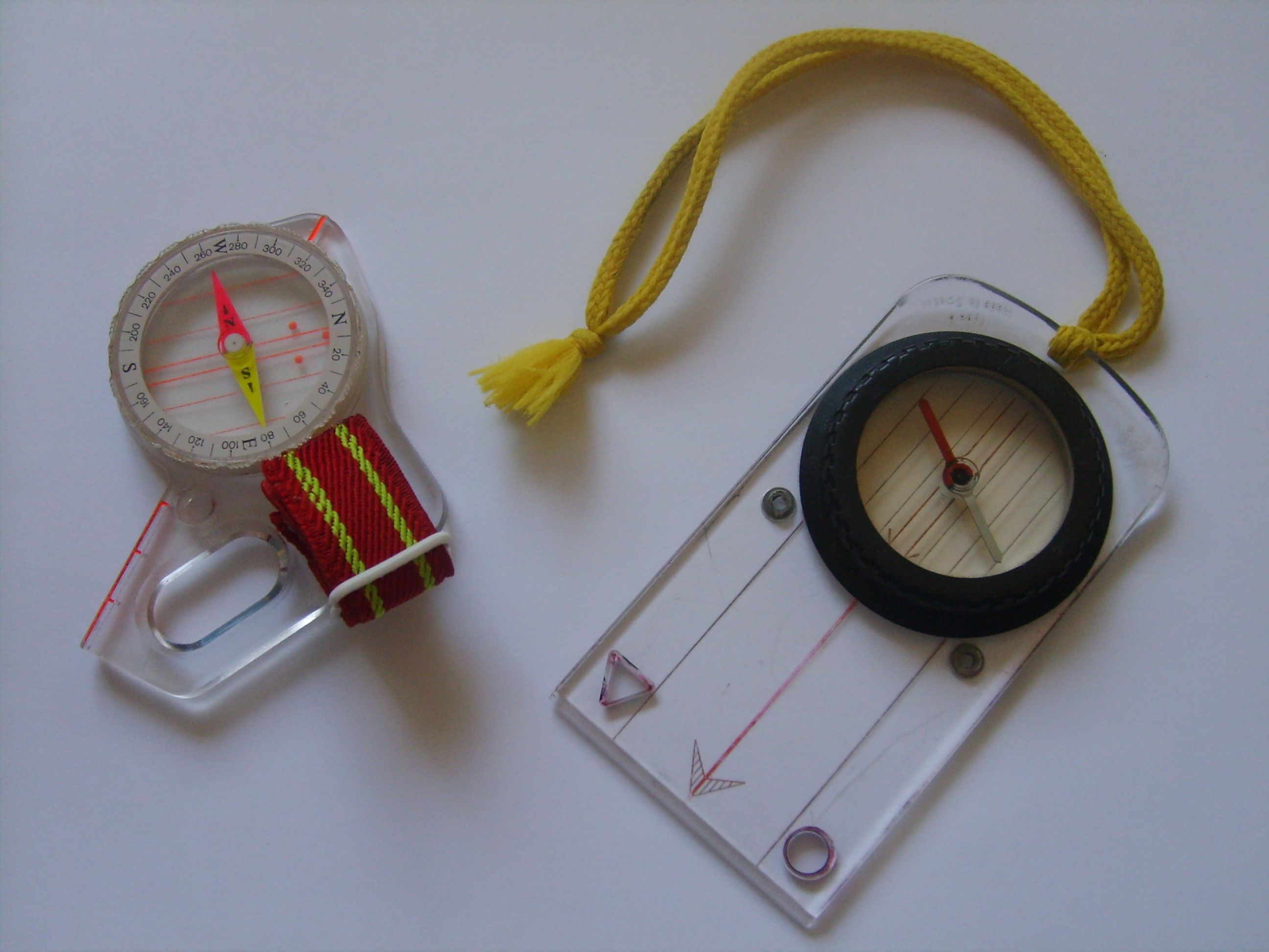
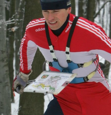
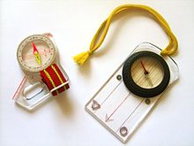 Thumb compass and protractor compass
The basic equipment required for orienteering is usually listed as a compass and appropriate outdoor clothing. Some national bodies such as the UK[34] recommend that a whistle be carried for safety.
Competitive orienteers usually use specialized equipment:
- A thumb compass, or protractor compass on a short wrist cord.
- A clear map case to protect the map. May be provided by organizers in competitions.
- A clear plastic sleeve, worn on the forearm, to hold control descriptions.
- Eye protectors to protect eyes from branches, insects, dust and wind blast.
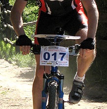
- A map board, fixed to the handlebars or worn on the arm or strapped to the torso (MTB-O, Ski-o and ARDF only).
- IOF rules forbid the use of artificial aids so GPS and other electronic navigation devices are not used. (ARDF may allow them at some events).
-

Foot orienteer wearing eye protectors
-

ARDF orienteer wearing a map board on his left arm
-

Ski orienteer wearing a map board on a torso harness
-

Mountain bike orienteer with a map board on bike handlebars
Competition types
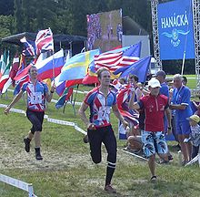 Foot-O relay, the winner crosses the line - joined by the rest of his team
Classic
Classic orienteering involves a race between controls in a preset order. The winner is the person who completes the course in the shortest time. Courses are normally designed so that the fastest route is not straightforward to find on the map, or to follow on the ground.
Relay
A relay race is run by a team of competitors each running a course, and the result is based on the team's total time. Relays usually employ a mass start instead of a staggered start. To reduce competitors following each other, parallel courses are provided. For a team of three: three courses could be provided (a, b, c) with each of the team members running one course. To prevent following, teams run the courses in different orders, e.g., abc, bca, cab. In the larger events these courses cross over and have a common control. Those courses can then be split into two parts, e.g., a, b, c and x, y, z. Each team has to run all six parts but competitors run one of nine different combinations, e.g., ax, ay, az … cx, cy, cz”.[35]
Score
Competitors visit as many controls as possible within a time limit. There is usually a mass start (rather than staggered), with a time limit. Controls may have different point values depending on difficulty, and there is a point penalty for each minute late. The competitor with the most points is the winner.
The large-scale, endurance-style version of a Score-O is known as a rogaine, competed by teams in events lasting (often) 24 hours. A very large area is used for competition, and the map scale is smaller. The format originated in Australia. The term ROGAINE is often said to stand for Rugged Outdoor Group Activity Involving Navigation and Endurance; this is essentially a backronym, as the name actually originates from the names of Rod, Gail and Neil Phillips, who were among Australian Rogaining's first participants.[36]
Sprint
Shorter events, often held in city parks and other more urban settings. Map scales are usually 1:5,000 or 1:4,000. Control sites can include benches, litterbins, sculptures, and other objects common to urban parks.[37]
Ultrasprint
Ultrasprint events are held in a specially constructed labyrinth. Due to the limited area of the labyrinth, ultrasprint is a more spectator-friendly form of orienteering. Also, as the course is artificial, identical courses can be set in different geographical locations for simultaneous local competitions as parts of a larger tournament.
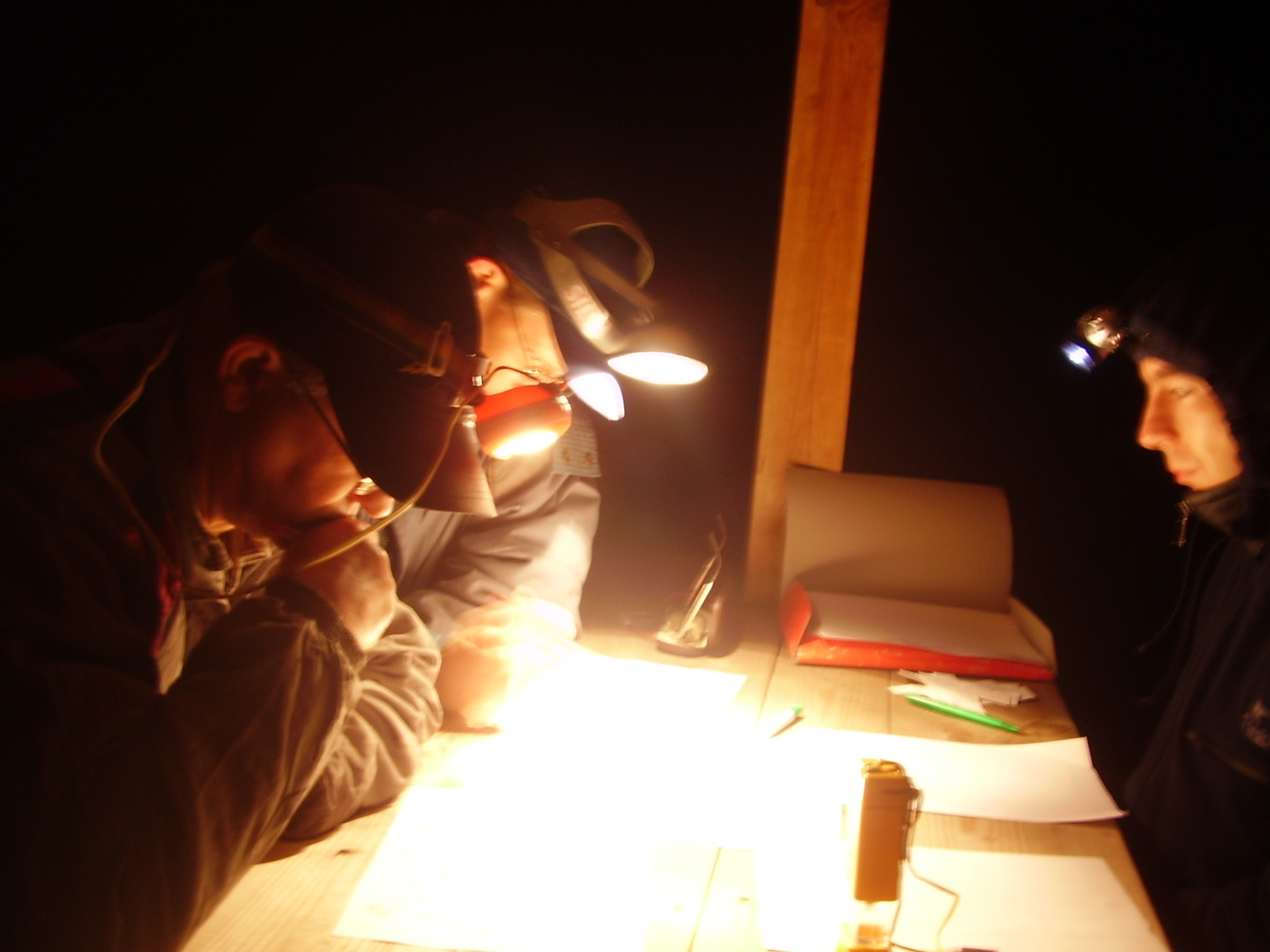
Night
 Studying the map at the start of a night-o
Competitors use a headlamp to navigate in the dark. Reflective markers often are used on control point flags, which shifts the tactics from precision navigation to searching. Competitors can travel at high speed to the vicinity of the control point, then sweep the area with the light to catch a reflection off the control flag. If a night event starts before dark, a mass start must be used so all competitors have equal time in the light and dark. The two classic club relays, Tiomila and Jukola, both include night legs.[38] Full length (24 hour) rogaines and many adventure races run through the night, without a dark period, and competitors may choose not to rest.
String
Competitors follow a string around a short course, noting down things that they find on the way. This is generally used by young children and people new to the sport who want to find out what it is like.[39]
Precision
Precision orienteering generally is not a speed event, but rather a test of the competitors' ability to precisely match map and terrain. Examples include trail-O (untimed), TREC style mounted orienteering, and Radio Orienteering in a Compact Area (ROCA). Both trail-O and ROCA use decoys in the vicinity of the control point.
Orienteering and the Olympics
Efforts begun in 1996 to promote the inclusion of orienteering in the Olympic Games have so far been unsuccessful, although orienteering became a sport in the World Games in 2001, and is a sport in the Summer Deaflympics. Supporters recognize that the sport is neither television- nor spectator-friendly, the venue of competition is often necessarily remote from major cities, and the duration of the event is longer than most other individual competitions.[40] Efforts to develop a format suitable for Olympic competitions have focused on park orienteering, micro-orienteering, and short-distance relays. Sprint Orienteering on foot as a format of the sport is most likely to be included in Olympic Games, as this discipline is becoming more and more popular worldwide and can have a significant spectator interest. According to the website of a Chicago Orienteering club, "the International Orienteering Federation is committed to entering the Olympic World."[41]
Although not an official demonstration sport, an international ski-orienteering event was held in Sugadaira Kōgen, Japan, as part of the International Cultural Festival held in conjunction with the XVIII Winter Olympic Games in Nagano in 1998.[42] The International Orienteering Federation petitioned the International Olympic Committee in 2002 to include ski orienteering in the 2006 Winter Olympic Games, noting that it could share the venue with the biathlon competitions.[43] In its formal recommendation that ski orienteering not be included in those games, the Olympic Programme Commission focused on a lack of participation in the sport outside Nordic countries, "the challenges for broadcasters and spectators to easily follow the competition", and the costs associated with new technology and a new results system.[44] In 2005, the International Olympic Committee confirmed that ski orienteering was under consideration for inclusion in the review process of the Olympic sport program for the 2014 Winter Olympic Games.[45] On November 28, 2006, the Executive Board of the IOC decided not to include any new sports, among them ski orienteering, into this review process.[46]
See also
References
- ^ "About Orienteering" (in English). The Canadian Orienteering Federation. http://www.orienteering.ca/about_orienteering.htm. Retrieved 2008-08-11.
- ^ "Orienteering" (in English). International World Games Association. http://www.worldgames-iwga.org/vsite/vcontent/page/custom/0,8510,1044-167458-184676-18067-62418-custom-item,00.html. Retrieved 2008-09-29.
- ^ "Sports" (in English). World Police Fire Games. http://www.2009wpfg.ca/content/sports/index.shtml. Retrieved 2008-09-29.
- ^ "About us" (in English). International Orienteering Federation. http://www.orienteering.org/i3/index.php?/iof2006/iof/about_us. Retrieved 2008-08-11.
- ^ "Rules and Guidelines" (in English). International Orienteering Federation. http://www.orienteering.org/i3/index.php?/iof2006/document_library/rules_and_guidelines. Retrieved 2008-09-28.[dead link]
- ^ "About us". International Orienteering Federation. http://www.orienteering.org/i3/index.php?/iof2006/iof/about_us. Retrieved 2008-05-26.
- ^ "IOF". International Orienteering Federation. http://www.orienteering.org/i3/index.php?/iof2006/iof. Retrieved 2008-05-26.
- ^ "Vision and values". International Orienteering Federation. http://www.orienteering.org/i3/index.php?/iof2006/iof/vision_and_values. Retrieved 2008-05-26.
- ^ "Past&Present" (in English). International Orienteering Federation. http://www.orienteering.org/i3/index.php?/iof2006/iof/past_present. Retrieved 2008-09-28.
- ^ "About British Orienteering". British Orienteering Federation. http://www.britishorienteering.org.uk/about/index.php. Retrieved 2008-05-25.
- ^ "BAOC Online". baoc.org.uk. http://www.baoc.org.uk/. Retrieved 2008-09-28.
- ^ "International Rogaining Federation". www.rogaining.com. http://www.rogaining.com/. Retrieved 2008-10-28.
- ^ "International Amateur Radio Union" (in English). International Amateur Radio Union. http://www.iaru.org/. Retrieved 2008-11-13.
- ^ a b c "Past & present" (in English). International Orienteering Federation. http://www.orienteering.org/i3/index.php?/iof2006/iof/past_present. Retrieved 2008-09-28.
- ^ "Milstolpar i utvecklingen" (in Swedish). Svenska Orienteringsförbundet. http://www.orientering.se/t2.asp?p=3398. Retrieved 2008-09-29.[dead link]
- ^ "National Federations" (in English). International Orienteering Federation. http://www.orienteering.org/i3/index.php?/iof2006. Retrieved 2006-02-19.
- ^ "Orienteering: A Brief History" (in English). Orienteering Australia. http://www.orienteering.asn.au/promotion/facts/History/. Retrieved 2008-11-13.
- ^ Pulkkinen, Sanna. "The Jukola Relay is about much more than orienteering" (in English). Helsingin Sanomat. http://www.hs.fi/english/article/The+Jukola+Relay+is+about+much+more+than+orienteering+/1135228145846. Retrieved 2008-11-13.
- ^ a b "Your first orienteering event". orienteer.com. http://orienteer.com/nutshell.htm. Retrieved 2008-09-28.
- ^ "Foot Orienteering" (in English). Orienteering Queensland. http://www.oq.asn.au/index.php?option=com_content&task=view&id=26&Itemid=85. Retrieved 2008-09-28.
- ^ "International_Specification_for_Orienteering_Maps" (PDF). http://www.orienteering.org/i3/index.php?/iof2006/content/download/866/4026/file/International_Specification_for_Orienteering_Maps_2000.pdf. Retrieved 2008-06-16.
- ^ "The Map". www.williams.edu. http://www.williams.edu/Biology/Faculty_Staff/hwilliams/Orienteering/map.html. Retrieved 2008-09-28.
- ^ a b c "Details of the sport of orienteering". http://www.orienteeringunlimited.com/ODetails.htm. Retrieved 2008-09-28.
- ^ "Courses and classes - cutting through the confusion." (in English). Wight Orienteers. 1997. http://www.lionking.org/~wighto/clsandcrs.htm. Retrieved 2008-09-28.
- ^ "Orienteering Clue Symbols". www.williams.edu. http://www.williams.edu/Biology/Faculty_Staff/hwilliams/Orienteering/clues.html. Retrieved 2008-09-28.
- ^ "Orienteering". www.runningforfun.co.uk. http://www.runningforfun.co.uk/orienteering.html. Retrieved 2008-09-28.
- ^ "What is a permanent orienteering (O') course?". US Orienteering Federation. http://www.us.orienteering.org/POC.html. Retrieved 2008-09-28.[dead link]
- ^ "Permanent orienteering courses" (in English). South London Orienteers and Wayfarers. http://www.sloweb.org.uk/poc/pocinfo.htm. Retrieved 2008-09-28.[dead link]
- ^ "IOF Control descriptions" (in English) (PDF). International Orienteering Federation. http://www.orienteering.org/i3/index.php?/iof2006/content/download/1787/8358/file/IOF%20Control%20Descriptions%202004.pdf. Retrieved 2008-09-30.
- ^ "Your first orienteering event" (in English). orienteer.com. http://orienteer.com/nutshell.htm. Retrieved 2008-11-13.
- ^ "Appendix I : Electronic Punching" (PDF). www.britishorienteering.org.uk. http://www.britishorienteering.org.uk/downloads/documents/Appendices_IElectronicPunching.pdf. Retrieved 2008-10-23.
- ^ "Organisers are responsible for" (in English). British Orienteering Federation. Archived from the original on 2008-08-04. http://web.archive.org/web/20080804112125/http://www.britishorienteering.org.uk/event/organisers.php#responsibilities. Retrieved 2008-11-13.
- ^ "IOF Foot-O Rules". Archived from the original on 2008-06-14. http://web.archive.org/web/20080614090613/http://www.orienteering.org/i3/index.php?/iof2006/document_library/rules_and_guidelines/foot_orienteering. Retrieved 2008-11-14.
- ^ a b "BOF Event Rules" (PDF). http://www.britishorienteering.org.uk/downloads/documents/2007Rules_Jan07.pdf. Retrieved 2008-11-14.
- ^ "Types of Orienteering Events". http://qoc.nova.org/type_of_.htm. Retrieved 2008-05-08.
- ^ "Point-to-point orienteering (also called Cross-country orienteering)". http://www.ptoc.org/begin_guide/htdocs/courses.html. Retrieved 2008-05-08.
- ^ "Internation Specification for Sprint Orienteering Maps" (in English) (PDF). International Orienteering Federation. April 15, 2008. http://lazarus.elte.hu/mc/specs/issom2005.pdf. Retrieved 2008-09-28.
- ^ "Night Navigation". http://www.4orienteering.com/terrain_association/56/. Retrieved 2008-05-08.
- ^ "The String Course". US Orienteering Federation. Archived from the original on 2008-04-07. http://web.archive.org/web/20080407002150/http://www.us.orienteering.org/OYoung/StringO.html. Retrieved 2008-05-08.
- ^ Brady, Gerry (2008). "The Olympics, Orienteering and Ireland". The Irish Orienteer. http://orienteering.ie/tio/94/OLYMPICS.htm. Retrieved 2008-08-16.
- ^ "Current Status of Orienteering in the Olympics" (in English). Chicago Area Orienteering Club. http://www.chicago-orienteering.org/newsletter/article0303f.htm. Retrieved 2008-09-28.
- ^ "Extensive discussion on the Olympic item" (in English). International Orienteering Federation. http://www.orienteering.org/press/ccil0197.htm. Retrieved 2008-09-28.[dead link]
- ^ Rönnberg, Barbro (March 2002). "Ski Orienteering's Olympic Bid" (in English). O-zine. International Orienteering Federation. http://www.orienteering.org/ozine0203.htm. Retrieved 2008-09-28.[dead link]
- ^ Cararro, Franco (2002). "Review of the Olympic Programme and the Recommendations on the Programme of the XX Olympic Winter Games, Turin 2006" (in English). Olympic Programme Commission. http://www.olympic.org/common/asp/download_report.asp?file=en_report_520.pdf&id=520. Retrieved 2008-09-28.
- ^ Barbrod, Rönnberg (December 2005). "Green light for continued Olympic campaign" (in English) (PDF). O-Zine. International Orienteering Federation. http://www.orienteering.org/ozine0512.pdf. Retrieved 2008-09-28.[dead link]
- ^ "Olympic programme updates" (in English). International Olympic Federation. http://www.olympic.org/uk/news/olympic_news/full_story_uk.asp?id=1972. Retrieved 2008-09-28.
External links
- International Orienteering Federation
- YouTube.com: Orienteering, USOF style
- The Gear Junkie - "How To: Orienteering" article.
Orienteering Orienteering concepts Sport disciplinesIOF governedIARU governedOther sportsRelated sportsEquipmentEventPersonalExceptionsFundamentalsMap (Orienteering map) · Navigation (Resection, Route choice, Wayfinding, Waypoint) · Racing (Hiking, Running, Walking)OrganizationNon-sport relatedAdventure travel · Bicycle touring · Location-based game (Geocaching, Poker run) · Hiking · Hunting · Mountaineering · Scoutcraft orienteering · Traveling backpacking · Wilderness backpackingOrienteering competition events Top ranked onlyOpen to everyoneTop ranked onlyTop ranked onlyWorld ChampionshipsOpen to everyoneList of orienteering eventsCategories:


Wikimedia Foundation. 2010.