- Nieuwe Waterweg
-
Coordinates: 51°56′31″N 4°11′29″E / 51.94194°N 4.19139°E
Nieuwe Waterweg New Waterway River  Mouth of the New Waterway at the North Sea
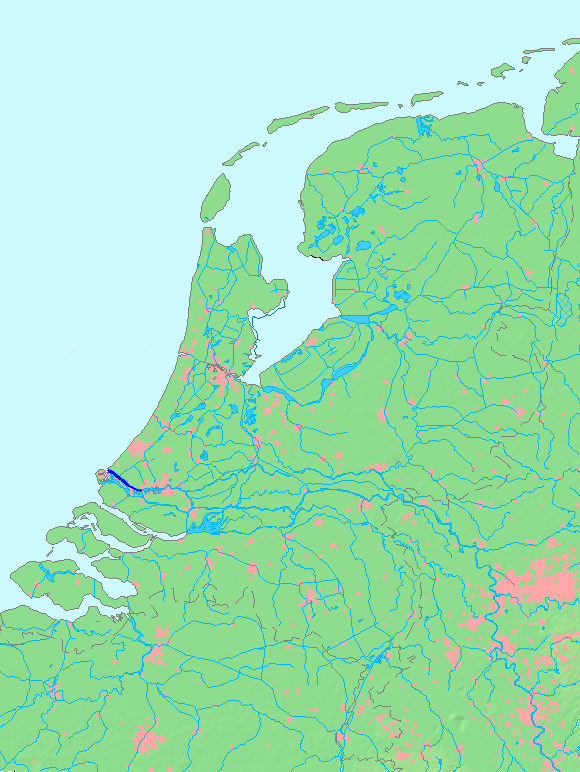
Country Netherlands State South Holland Source Het Scheur - location Maassluis Mouth North Sea - location Hoek van Holland Length 10 km (6 mi)  Location of Nieuwe Waterweg (including Het Scheur) in dark blue.
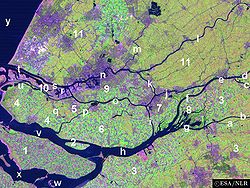
The Nieuwe Waterweg ("New Waterway") is a ship canal in the Netherlands from het Scheur (a branch of the Rhine-Meuse-Scheldt delta) west of the town of Maassluis to the North Sea at Hook of Holland. It is the artificial mouth of the river Rhine.
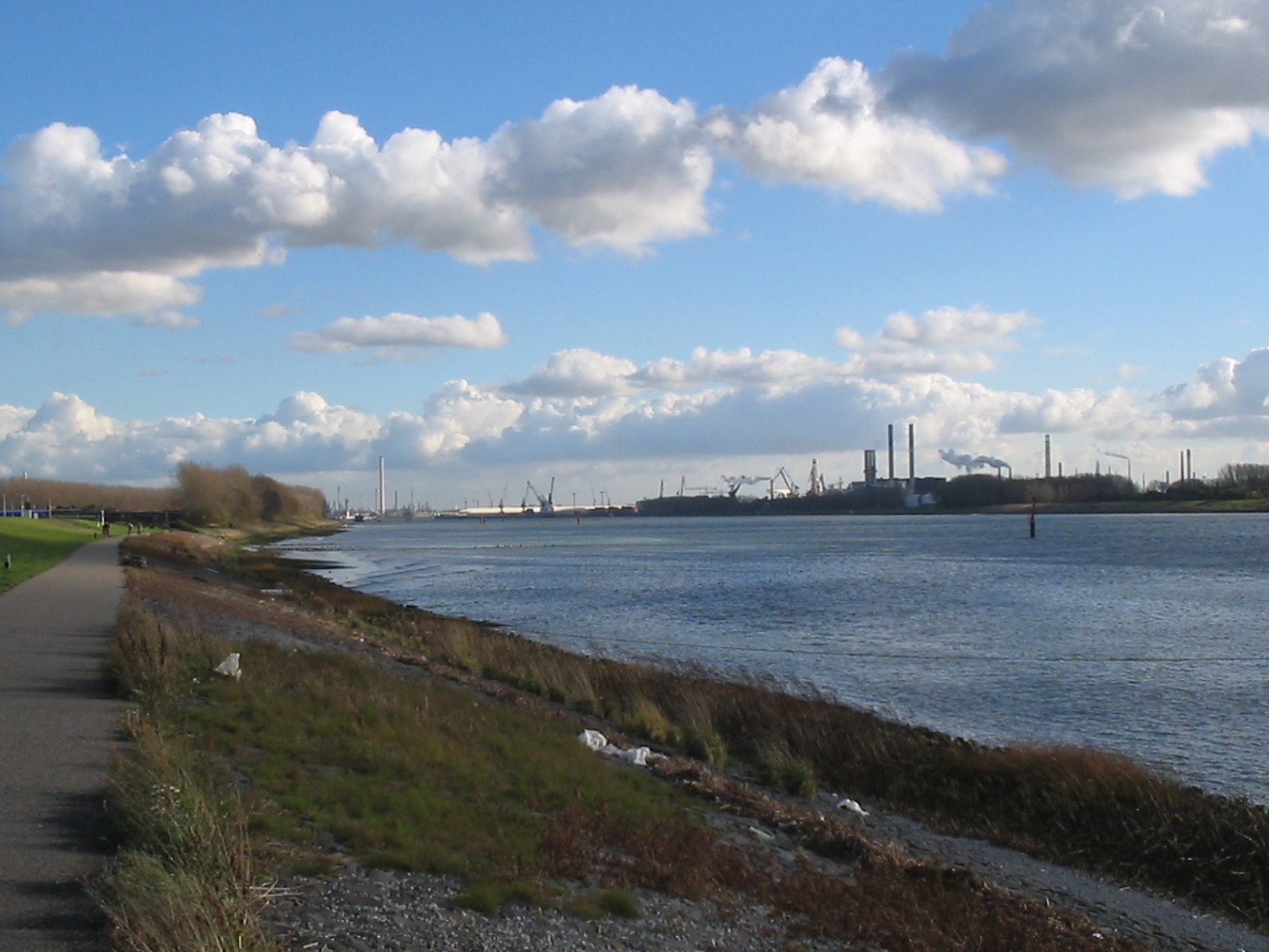
The Nieuwe Waterweg, which opened in 1872 and has a length of approximately 10 km, was constructed to keep the city and port of Rotterdam accessible to seafaring vessels as the natural Meuse-Rhine branches silted up. The Waterway is a busy shipping route since it is the primary access to one of the busiest ports in the world, the Europoort of Rotterdam. At the entrance to the sea, a flood protection system called Maeslantkering has been installed (completed in 1997). There are no bridges or tunnels across the Nieuwe Waterweg.
History
By the middle of the 19th century, Rotterdam was already one of the largest port cities in the world, mainly because of transshipment of goods from Germany to Great Britain. The increase in shipping traffic created a capacity problem: there were too many branches in the river delta, making the port difficult to reach.
In 1863, a law was passed which allowed for the provision of a new canal for large ocean-going ships from Rotterdam to the North Sea. Hydraulic engineer Pieter Caland was commissioned to design a canal cutting through the "Hook of Holland” and to extend the Mouth of Rhine to the sea. The designs for this were already done back in 1731 by Nicolaas Samuelsz Cruquius but the implementation could no longer be postponed to prevent the decline of the harbour of Rotterdam.
Construction began on October 31, 1863. The first phase consisted of the expropriation of farm lands from Rozenburg to Hoek van Holland.
During the second phase two dikes were built parallel to each other, which took 2 years. Caland proposed to extend the dikes 2 km into the sea to disrupt the coastal sea currents and decrease silt deposits in the shipping lane.
Upon the completion of the dikes, the third phase began by the digging of the actual waterway. This began on October 31, 1866, and was completed three years later. The large amounts of removed soil were in turn used to reinforce other dams and dikes.
The last phase consisted of the removal of the dam separating the new waterway from the sea and river. In 1872, the Nieuwe Waterweg was completed and Rotterdam was easily accessible.
Because of the currents and erosion, the shipping lane has been widened somewhat. Yet because of the draft of today's supertankers, it needs to be dredged constantly.
In 1997, the last part of the Delta Works, the Maeslantkering, was put in operation near the mouth of the Nieuwe Waterweg. This storm surge barrier protects Rotterdam against north westerly Beaufort Force 10 to 12 storms.
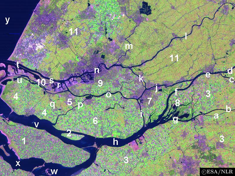
 Satellite image of the northwest part of the Rhine-Meuse delta showing the Nieuwe Waterweg (t).
 Nieuwe Waterweg
External links
Rhine
Rijn
RhinCurrent distributaries: Waal · Nederrijn · IJssel · Lek · Merwede · Boven Merwede · Nieuwe Merwede · Beneden Merwede · Oude Maas · Dordtsche Kil · Noord · Nieuwe Maas · Het Scheur · Nieuwe Waterweg
Associated canals: Bijlands Kanaal · Pannerdens Kanaal · Amsterdam–Rhine Canal · Vaartse Rijn · Nieuwe Merwede · Nieuwe Waterweg · Scheldt–Rhine Canal · Maas-Waal Canal
Former distributaries: Kromme Rijn · Leidse Rijn · Oude Rijn · Hollandse IJssel · Vecht · Brielse Maas · Spui
Current estuaries: Nieuwe Waterweg · IJsselmeer
Former estuaries: Hollands Diep · Haringvliet · Volkerak · Krammer · Grevelingen · Keeten-Mastgat · OosterscheldeMeuse
MaasCurrent distributaries: Bergse Maas · Amer
Associated canals: Heusden Canal · Bergse Maas · Maas-Waal Canal
Former distributaries: Oude Maasje · Afgedamde Maas · Merwede · Boven Merwede · Beneden Merwede · Oude Maas · Dordtsche Kil · Noord · Nieuwe Maas · Het Scheur · Nieuwe Waterweg
Current estuaries:
Former estuaries: Hollands Diep · Haringvliet · Volkerak · Krammer · Grevelingen · Keeten-Mastgat · OosterscheldeScheldt
Schelde
EscautCurrent distributaries: Western Scheldt
Associated canals: Scheldt–Rhine Canal
Former distributaries: Oosterschelde · Eendracht
Current estuaries: Western Scheldt
Former estuaries: Oosterschelde · Krammer · GrevelingenOther rivers
(directly draining
into the delta)Islands and
PeninsulasTowns Rotterdam · Antwerp · Dordrecht · Bergen-op-Zoom · Schiedam · Vlissingen · Vlaardingen · Middelburg · SpijkenisseOther topics Delta Works · Verdronken Land van Reimerswaal · Verdronken Land van Saeftinghe · St. Elizabeth's flood (1421) · St. Felix's Flood · All Saints' Flood (1570)Categories:- Canals in the Netherlands
- Rhine–Meuse–Scheldt delta
- Port of Rotterdam
Wikimedia Foundation. 2010.