- Schouwen-Duiveland
Infobox Settlement
official_name = Schouwen-Duiveland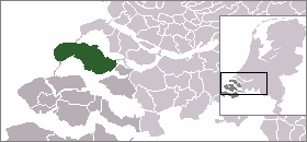
mapsize = 280px
subdivision_type = Country
subdivision_name =Netherlands
subdivision_type1 = Province
subdivision_name1 =Zeeland
area_footnotes = (2006)
area_total_km2 = 488.94
area_land_km2 = 231.07
area_water_km2 = 257.87
population_as_of =1 January ,2007
population_note = Source: CBS, [http://statline.cbs.nl/ Statline] .
settlement_type = Municipality
population_total = 34152
population_density_km2 = 148
timezone = CET
utc_offset = +1
timezone_DST = CEST
utc_offset_DST = +2Schouwen-Duiveland (Pronunciation|247 Schouwen-Duiveland.ogg) is a
municipality and anisland in the southwesternNetherlands .The Brouwersdam is a
dam , part of theDelta Works , from Schouwen-Duiveland toGoedereede , the west part of the island ofGoeree-Overflakkee inSouth Holland .Population centers
Brijdorpe ,Brouwershaven ,Bruinisse , Burgh,Burghsluis ,Dreischor ,Elkerzee ,Ellemeet ,Haamstede ,Kerkwerve ,Looperskapelle ,Moriaanshoofd ,Nieuwerkerk ,Nieuwerkerke ,Noordgouwe ,Noordwelle , Oosterland,Ouwerkerk ,Renesse ,Scharendijke ,Schuddebeurs , Serooskerke,Sirjansland ,Westenschouwen ,Zierikzee ,Zonnemaire .There is no village called Schouwen-Duiveland itself — the municipality takes its name from the island, which itself got its name when the former islands Schouwen and Duiveland (and Dreischor) were
polder ed together.External links
* [http://www.schouwen-duiveland.nl official website] (in Dutch)
* [http://www.plattegronden.nl/gemeenteschouwen-duiveland/index.html municipal maps] (in Dutch)
* [http://www.weerstation-zierikzee.nl/ weather station Schouwen Duiveland] (in Dutch)
Wikimedia Foundation. 2010.