- Tholen
Infobox Settlement
official_name = Tholen
mapsize = 280px
subdivision_type = Country
subdivision_name =Netherlands
subdivision_type1 = Province
subdivision_name1 =Zeeland
area_footnotes = (2006)
area_total_km2 = 254.41
area_land_km2 = 147.81
area_water_km2 = 106.60
population_as_of =1 January ,2007
population_note = Source: CBS, [http://statline.cbs.nl/ Statline] .
settlement_type = Municipality
population_total = 25158
population_density_km2 = 170
timezone = CET
utc_offset = +1
timezone_DST = CEST
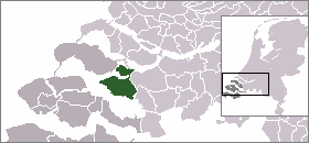
utc_offset_DST = +2Tholen (Pronunciation|250 Tholen.ogg) is a
municipality in the southwest of theNetherlands . The municipality of Tholen has loaned its name from the town of Tholen, which is the largest population center in the municipality.The municipality consists of two
peninsula s, formerlyisland s, the larger one on the south also called Tholen, the smaller one on the north called Sint Philipsland. The two are separated by the former strait, nowbay , ofKrabbenkreek .The municipality is bordered on the east by the
Eendracht , once aScheldt branch but now part of theScheldt-Rhine Canal , crossed by threeroad bridge s; by theOosterschelde estuary to the south; thestrait s ofKeeten -Mastgat to the west; and theKrammer strait to the north.Population centers
On the island Sint Philipsland there are three villages:
*Sint Philipsland
*Anna Jacobapolder
*De Sluis On the island Tholen there are seven population centers:
*Oud-Vossemeer
*Poortvliet
*Scherpenisse
*Sint Annaland
*Sint Maartensdijk
*Stavenisse
*TholenExternal links
* [http://www.tholen.nl official website]

Wikimedia Foundation. 2010.