- Manukau City
-
This article is about the former territorial authority Franklin District, which was abolished on 1 November 2010. For the new city authority or council, see Auckland Council. For the suburb, see Manukau.
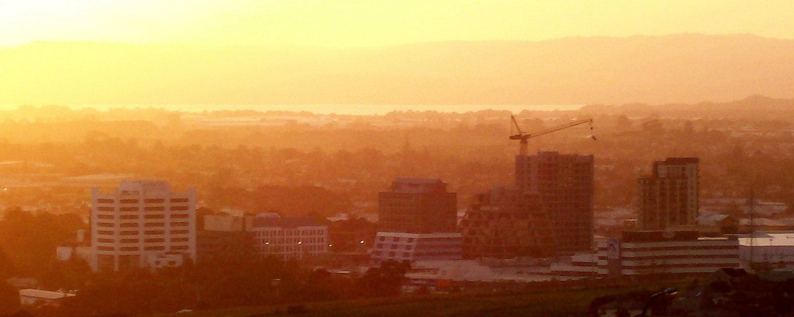
Manukau City — Territorial authority of New Zealand — The Manukau skyline looking northwest.
Nickname(s): South Auckland Manukau City's location within New Zealand Manukau City's location (shown in orange) within the Auckland metropolitan area. The darker orange indicates the urban area.
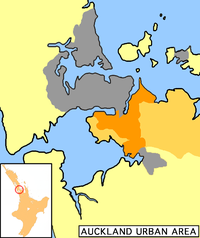
Country  New Zealand
Island North Island Region Auckland Wards Botany-Clevedon, Howick, Mangere, Manurewa, Otara, Pakuranga, Papatoetoe Government – Mayor Barry Curtis (1989–2007), Len Brown (2007–2010) Area – Total 683 km2 (263.7 sq mi) Population (June 2010 estimate)[1] – Total 375,600 – Density 549.9/km2 (1,424.3/sq mi) Time zone NZST (UTC+12) – Summer (DST) NZDT (UTC+13) Area code(s) 09 Website http://www.manukau.govt.nz/
http://www.arc.govt.nz/Manukau City was a large territorial authority in Auckland, New Zealand. The city was sometimes referred to as South Auckland, but this term did not possess official recognition and did not encompass areas like East Auckland, which was previously within the official boundaries of Manukau City. Manukau City was a relatively young city, both in terms of legal status and large-scale settlement – though with a current size of 375,600 inhabitants (June 2010 estimate),[1] it was also the third-largest in New Zealand as well as the country's fastest-growing.[2] The city existed from 1989 until 2010, when the entire Auckland Region was amalgamated into a single city authority, Auckland Council.
The name Manukau, from the Manukau Harbour west of the city, is of Māori origin, and means 'wading birds',[citation needed] although it has been suggested that the name of the harbour was also sometimes rendered as Mānuka, meaning a marker post with which an early chief is said to have claimed the area.[3]
Contents
History
Manukau City was formed by the amalgamation of Manukau County and Manurewa Borough in 1965. The city expanded in 1989 with New Zealand-wide reorganisation of local government to include Papatoetoe City and Howick Borough. However, some land was lost in the formation of Papakura District at the same time. On November 1, 2010 Manukau City was abolished and the governed area was amalgamated into the Manukau, Howick, Manurewa-Papakura, and Franklin wards of the new Auckland super city.
Geography
The Manukau City area was concentrated immediately to the south of the Otahuhu isthmus, the narrowest connection between Auckland City and the Northland region and the rest of the north island. At its narrowest, between the Otahuhu Creek arm of the Tamaki River (itself an estuarial arm of the Hauraki Gulf) in the east and the Mangere Inlet (an arm of the Manukau Harbour) to the west, the isthmus is only some 1500 metres across.
The area to the south of the isthmus contained the heart of Manukau, sprawled on either side of State Highways 1 and 20, the latter of which approaches from the west after crossing Mangere Bridge. The area known as Manukau Central is located close to the junction of these two highways, some 20 kilometres southeast of the centre of Auckland city.
Considerable rural and semi-rural land to the east of Manukau central were also within the city's limits. This extended towards the Hunua Ranges close to the Firth of Thames, and took in such communities as Clevedon and Maraetai.
Beyond Manukau City to the south was Papakura and the Franklin District, which are less urban but still part of the Auckland Region and to some extent regarded as an integral part of Auckland's urban area.
Auckland Airport is located in Mangere, in the west of Manukau, close to the waters of the Manukau Harbour. Manukau City included the theme park Rainbow's End, and one of the oldest shopping malls in the country, now called Westfield Manukau City.
Transport
In 2009, work started on a passenger branch railway junctioning with the North Island Main Trunk at Puhinui.[4] The new branch will serve a university campus.
Population
For some years before the 1989 reorganisation of local government, the then Manukau City had the highest population of any city or district in the country.
Like most of the rest of the region, Manukau is ethnically diverse, and is home to many peoples, especially Māori and members of Polynesian ethnicities, with a recent concentration of Asians in and near Howick. It is densely populated by New Zealand standards, despite having very few apartments.
As of the late 2000s, slightly less than 50% of the city's population identifies as European, with 17% as Māori, 27% as Pacific and 15% as Asian, with the balance made up of other groups.[2]
Schools
Main article: List of schools in Auckland#Manukau CityWards and suburbs
Manukau City was divided into 7 wards during its existence. The names of wards and lists of main suburbs/towns were:
- Botany-Clevedon Ward
- Ardmore
- Whitford
- Alfriston
- Tuscany Estates
- Brookby
- Orere Point
- Chapel Downs
- Clevedon
- Beachlands
- Dannemora
- Maraetai
- Beachlands
- Botany Downs
- Kawakawa Bay
- North Park
- Somerville
- Greenmeadows
Howick Ward
- Howick
- Eastern Beach
- Highland Park
- Meadowlands
- Mellons Bay
- Cockle Bay
- Shelly Park
Mangere Ward
- Airport Oaks
- Mangere Bridge
- Mangere East
- Mangere
- Middlemore
- Favona
Manurewa Ward
- Manurewa
- Clendon
- Wiri
- Manukau Heights
- Manukau Central
- Weymouth
- Waimahia Landing
- Wattle Cove
- Wattle Downs
- Silkwood Heights
- The Gardens
- Totara Heights
- Randwick Park
- Redoubt Park
- Heron Point
- Murphy's Heights
- Mahia Park
- Hill Park
- Goodwood Heights
- Porchester Park
- Settlers Cove
Otara Ward
- 'South' Otahuhu
- Otara
- East Tamaki
- Clover Park
- Flat Bush
Pakuranga Ward
Papatoetoe Ward
- Papatoetoe
- Puhinui
Prominent people
- Len Brown, former Mayor, now Auckland super city Mayor.
- Jim Anderton, former city councillor, who rose to be the country's Deputy Prime Minister.
- Sir Barry Curtis, former long-serving Mayor, from 1983 to 2007.
- David Lange, former Prime Minister of New Zealand and Member of Parliament for Mangere.
- Award-winning rapper and former member of The Deceptikonz, Savage.
Local government
The Manukau City Council was the elected local authority of the city from 1965 until November 2010 when the new Super City Council Auckland Council was created.
Youth Council
Manukau City was an elected Youth Council which primarily acted as an advisory committee and advocate for youth in the city. It is unknown if this Youth Council will be continued with the new Auckland Council.
Sister cities
References
- ^ a b "Subnational population estimates at 30 June 2010 (boundaries at 1 November 2010)". Statistics New Zealand. 26 October 2010. http://www.stats.govt.nz/~/media/Statistics/Methods%20and%20Services/Tables/Subnational%20population%20estimates/subpopest2001-10.ashx. Retrieved 7 March 2011.
- ^ a b About Manukau (from the Manukau City Council website. Accessed 2008-06-21.)
- ^ Manukau – Naming the harbour (from Te Ara Encyclopedia of New Zealand. Accessed 2008-06-22.)
- ^ Dearnaley, Mathew (18 September 2009). "Work starts on $90m rail link". The New Zealand Herald. http://www.nzherald.co.nz/rail/news/article.cfm?c_id=296&objectid=10597981. Retrieved 19 October 2011.
External links
- Official Auckland Council website
- Official website from 1965 – 1 November 2010
- Manukau Directory and Info
- Manukau Street Map
- Manukau Libraries
- Manukau City Youth Council
Categories:- Main urban areas in New Zealand
- Territorial Authorities of New Zealand
- Populated places established in 1989
- Populated places disestablished in 2010
- Geography of Auckland
- History of Auckland

Wikimedia Foundation. 2010.