Mangere Bridge, New Zealand

Mangere Bridge, New Zealand
Mangere Bridge
Western Mangere Bridge From Mountain.jpg
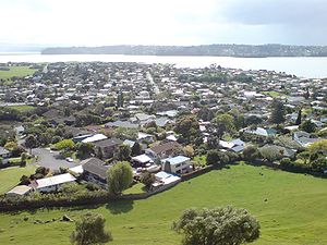
Western part of the suburb seen from Mangere Domain.
Basic information
Local authority Auckland City
Population 5,484 (2001)
Facilities
Surrounds
North (Manukau Harbour)
Northeast (Mangere Inlet)
East Favona
Southeast Favona
South Mangere
Southwest (Manukau Harbour)
West (Manukau Harbour)
Northwest (Manukau Harbour)
v · d · e
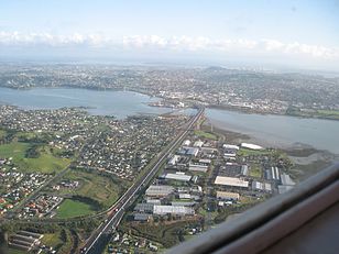
The Mangere Bridge suburb to the lower left, as well as the Mangere Bridge(s) in the background.

Mangere Bridge is an Auckland suburb under the local governance of the Auckland Council, at the south end of Mangere's bridge over the Manukau Harbour. It is part of the wider suburb of Mangere. It is home to Mangere Mountain and the Ambury Farm Park run by the Auckland Council, and backs onto rural land surrounding the Auckland Airport.[1]

It is a multicultural area, often with large families, with the suburb dominated by brick-and-tile homes built in the 1960s-1970s.[1]

Association football

Mangere Bridge is home to Onehunga-Mangere United who compete in the Lotto Sport Italia NRFL Division 1.[citation needed]

References

External links

Coordinates: 36°56′36″S 174°47′5″E / 36.94333°S 174.78472°E / -36.94333; 174.78472


Wikimedia Foundation. 2010.

Игры ⚽ Поможем сделать НИР

Look at other dictionaries:

  • Mangere Bridge — can refer to two places in New Zealand: Mangere Bridge, New Zealand, a suburb of Auckland City Mangere Bridge (bridges), the bridges that gave the suburb its name This disambiguation page lists articles associated with the same title. If an …   Wikipedia

  • Mangere Bridge (bridges) — For the suburb of the same name at the south end of the bridge, see Mangere Bridge, New Zealand. The duplicated Mangere Bridge seen from the south, with the suburb of the same name to the left …   Wikipedia

  • Mangere Bridge (bridge) — For the suburb of the same name at the south end of the bridge, see Mangere Bridge, New Zealand Mangere Bridge, officially also called the Manukau Harbour Crossing, is a motorway bridge over the Manukau Harbour in south western Auckland, New… …   Wikipedia

  • Māngere (New Zealand electorate) — Māngere is a New Zealand Parliamentary electorate, returning one Member of Parliament to the New Zealand House of Representatives. The current MP for Māngere is Su a William Sio[1], elected for the Labour Party. He has held this seat since 2008.… …   Wikipedia

  • New Zealand general election, 2008 — 2005 ← members 8 November 2008 (2008 11 08) …   Wikipedia

  • Mangere (New Zealand electorate) — Māngere is a New Zealand Parliamentary electorate, returning one Member of Parliament to the New Zealand House of Representatives. The current MP for Māngere is Taito Phillip Field [ [http://www.parliament.nz/en NZ/MPP/MPs/MPs/0/7/f/48MP871 Field …   Wikipedia

  • New Zealand State Highway 20 — State Highway 20 Southwestern Motorway Route information Maintained by New Zealand Transport Agency …   Wikipedia

  • Royal Oak, New Zealand — Suburb:Royal OakCity:AucklandIsland:North IslandSurrounded by to the north to the north east to the east to the south east to the south to the south west to the west to the north west Epsom (3.0 km) One Tree Hill (1.7 km) Oranga (1.7 km) Onehunga …   Wikipedia

  • Candidates in the New Zealand general election 2008 by electorate — Contents 1 General electorates 1.1 Auckland Central 1.2 Bay of Plenty 1.3 …   Wikipedia

  • List of New Zealand police officers killed in the line of duty — This is a list of New Zealand Police officers killed in the line of duty. As of 2009, 29 police officers have been killed by criminal act,[1][2] and about 17 have died from accidental causes, during the execution of duty. There has been one… …   Wikipedia

Share the article and excerpts

Direct link
Do a right-click on the link above
and select “Copy Link”