- Condell Park, New South Wales
-
Condell Park
Sydney, New South Wales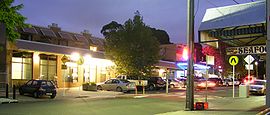
Evening at Condell Park shopping centre, Simmat Avenue, looking north.Population: 9,766 (2006 census) Postcode: 2200 Location: 21 km (13 mi) south-west of Sydney CBD LGA: Bankstown State District: East Hills Federal Division: Blaxland Suburbs around Condell Park: Georges Hall Yagoona Bankstown Bankstown Airport Condell Park Bankstown Milperra Revesby Padstow Condell Park, a suburb of local government area City of Bankstown, is located 22 kilometres south-west of the Sydney central business district, in the state of New South Wales, Australia, and is a part of the South-western Sydney region. The postcode of Condell Park is 2200, which is shared with Bankstown, Bankstown Airport, and Mount Lewis.[1]
Contents
History
Condell Park was named after Mr Ousley Condell, an engineer who arrived on 8 May 1829 on the barque Swiftsure with 13 other settlers. He applied for a position in the public service and was granted four 50-acre (200,000 m2) adjoining lots in 1830 that he called Condell Park.[2]
Black Charlie's Hill, located in Simmat Avenue Condell Park, was named after a local identity who's nickname was 'Black Charlie'. His real name is said to have been Charles Luzon or Charlie Lopez, a man of Aboriginal ancestry. He lived near Edgar Street, South Yagoona and like others in the area, during the early 1900s, grew vegetables that he carried off to the market by horse and cart. His home was constructed of corrugated iron. Black Charlie was said to fire a single shot each evening promptly at 9pm but the reason was never disclosed. Some suggested he was hunting rabbits, others to warn of the approach of aircraft.[3]
Bankstown Bunker
Main article: Bankstown BunkerThe Bankstown Bunker was an exact replica of the underground Ops rooms of wartime England, which directed Britain's air defence fighter plane attacks on the invading German Luftwaffe[4]. It had all the attenuated fixtures necessary to run a top secret operational defence base. The bunker was equipped with its own code room, plotting rooms, two escape tunnels and a radio transmitter room. In the centre of the bunker was a large room of about two-stories in height. This was the main Ops room and control centre for all RAAF Missions in the Pacific area. The room also had a large map of the South West Pacific theater of World War II[5][6][7].
The bunker still exists and access can be obtained through one of the old air vents. The entry point is located on private property in the backyard of a dwelling with an access tunnel running under a public park in which the bunker is buried. This is located at the end of Taylor Street, which can also be found on the corner of Marion and Edgar Streets, Condell Park. In 1976 the entire site was redeveloped into town houses which cover most of the land area. The area now comprises a number of separate complexes or "Closes" containing eight to eleven villas. Each Close is named appropriately after planes which flew from Bankstown during the Second World War.
Commercial area
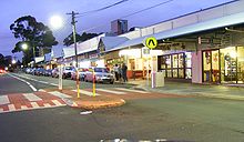 Condell Park Shopping Centre
There are a number of shops in Condell Park, including a Franklins supermarket, Liquorland, Commonwealth Bank and numerous other shops and restaurants. Most of the shops are located on a small section of Simmat Avenue, with a few other shops scattered around the suburb.
Schools
- Condell Park Public School (K-6)
- Condell Park High School (7-12)
- Condell Park Christian School (K-10)
Churches
Sport and recreation
Condell Park is home to the Bankstown Trotting Club, where Bankstown Markets are held every Sunday. The sporting venue Deverall Park is home to an extensive number of netball courts, 6 tennis courts, and the Bankstown Basketball Stadium which is the largest basketball stadium in Australia. Kinch Reserve, next to the Basketball Stadium, is home to Condell Park Football Club.
References
- ^ The Book of Sydney Suburbs, Compiled by Frances Pollen, Angus & Robertson Publishers, 1990, Published in Australia ISBN 0-207-14495-8, page 69
- ^ Bankstown Council - How Did Your Suburb Get Its Name?
- ^ Joan Lawrence, Brian Madden and Les muir. (Page 104). A Pictorial History of Canterbury Bankstown. (Alexandria: Kingsclear Books 1999. Printed by Australian Print Group.) Retrieved on the 3rd of August 2007.
- ^ "Teenagers raid bunker". BunkerBoyz.org. http://www.bunkerboyz.org/bankbunk2.htm
- ^ Lawrence, Joan.; Brian Madden and Lesliie Muir. (1999). http://www.kingsclearbooks.com.au/cb.html Pictorial History of Canterbury Bankstown.. Kingsclear Books. p. 89. ISBN 0-908272-55-3..
- ^ Peters, Merle (20.1.93). "Historian's account". Bankstown Torch Newspaper.
- ^ http://www.bunkerboyz.org/bankbunk.htm Bunker Boyz: Bankstown Bunker
External links
- Condell Park, New South Wales is at coordinates 33°55′30″S 151°00′28″E / 33.92498°S 151.00769°ECoordinates: 33°55′30″S 151°00′28″E / 33.92498°S 151.00769°E
- More info on the Bankstown Bunker including pictures of when it was in operation during The Second World War.
- Bankstown Bunker images
- Community Profile
- Condell Park Football Club
Categories:- Suburbs of Sydney
- City of Bankstown
- Populated places established in 1830


Wikimedia Foundation. 2010.