- Bankstown, New South Wales
Infobox Australian Place
type = suburb
name = Bankstown
city = Sydney
state = nsw
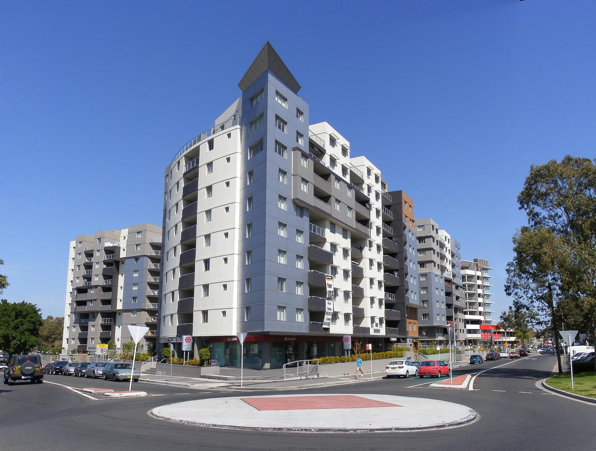
caption = Flats in Bankstown
lga =City of Bankstown
postcode = 2200
pop = 26,000 (2006)
area =
propval =
est = 1795
stategov = Bankstown
fedgov = Banks Blaxland
near-nw = Yagoona
near-n = Chullora
near-ne = Greenacre
near-w = Condell Park
near-e = Mount Lewis Punchbowl
near-sw = Revesby
near-s = Padstow
near-se = Riverwood
dist1 = 20
dir1 = south-west
location1=Sydney CBD Bankstown is a
suburb in south-westernSydney , in the state ofNew South Wales Australia . Bankstown is located 20kilometres south-west of theSydney central business district and is the administrative centre of the local government area of theCity of Bankstown .History
Prior to
Europe an settlement, Cumberland PlainsWoodland occupied much of the area.Turpentine ironbark forest covered much of what is now Bankstown. The land was occupied by an Aboriginal tribe calledEora . Their land bordered the Dharawal and the Darung people. The Aboriginal inhabitants strongly opposed the European settlers. The resistance ceased after a number of their leaders were killed or imprisoned in 1816. In that year an epidemic broke out amongst the native people which reduced the Aboriginal populations, this also contributed to the end of their resistance. [http://www.bankstown.nsw.gov.au/coun/about/yesterday.cfm About Bankstown Council ] ]In 1795
Matthew Flinders andGeorge Bass explored up theGeorge's River for about 20 miles beyond what had been previously surveyed, and reported favourably to Governor Hunter of the land on its banks. [gutenberg|no=12929|name=A Voyage to Terra Australis by Matthew Flinders] Hunter examined the country himself, and established one of the pioneer colonies there, called Bank's Town, today written as one word Bankstown. [gutenberg|no=7304|name=The Life of Captain Matthew Flinders, by Ernest Scott]Hunter named it in honour of botanist
Sir Joseph Banks , who travelled to Australia withCaptain James Cook in 1770. The area of first European settlement along the river has been partially preserved as part of theMirambeena Regional Park . The Bankstown City area includes large areas of theGeorges River National Park .One hundred years after its naming, Bankstown was proclaimed a municipal district on 9 September 1895. At this time there was a feeling of impending growth which was further strengthened by the promise of increased railway extensions. Municipalities already constituted became ambitious and in 1894, both Enfield and Auburn Councils announced their intention to absorb Bankstown as part of their own municipalities. However, a petition was organised and signed by 300 residents resulting in Bankstown retaining its individual status. And on 9 September 1895 it was proclaimed a municipal district. The first election was held on 2 November 1895. With 884 electors on the roll, 112 people voted to cast a total of 213 votes. Each ratepayer was entitled to 1.4 votes according to the assessed value of his property. Woman were not allowed to vote at this stage.
Bankstown’s first town hall and Council Chambers were built in 1898 on the northern side of the
Hume Highway (Liverpool Road), near Rookwood Road (site of the Three Swallows Hotel). The council chambers were relocated to a new building in South Terrace (now Old Town Centre Plaza) in June 1918. The building still stands and now has a shopping arcade running through it.Bankstown Council relocated to its third premises in 1963 when the Civic Centre that is located on the corner of Chapel Road and The Mall was constructed. It included the Council Chambers or ‘Roundhouse’, as it’s called and is still in use today as an administration building. The current town hall was built in 1973. The administration building was destroyed by fire on 1 July 1997. Council offices relocated to Bankstown Civic Tower (the blue tower) in 1999 and on 13 June 2000 Bankstown’s now popular Central Park, where the former administration building once stood, was officially declared Paul Keating Park. [ cite book
last =Maltby
first =Kathy
authorlink =www.bankstowncity.nsw.gov.au
coauthors =Rosen, Sue – Bankstown: Sense of Identity
title =From Settlement to City
publisher =Bankstown City Council
date =
location =Civic Tower 66-72 Rickard Road Bankstown
pages = Pages 13
url =
doi =
id =
isbn = ]On 27 May 1980, during a visit by Her Majesty Queen Elizabeth II, Bankstown was accorded city status.
World War II
In 1939 the residents of Bankstown were informed of World War II. Men and women from the district who had been drafted, were required to report for duty at a drill hall located on Canterbury Road Belmore. Camps were set up in and around Canterbury Racecourse and local parks in the area.
Residents with foreign names were sent to
internment camps . There was growing suspicion about residents with foreign names. Some of the people who were sent to the camps were Australian citizens who served with theAustralian armed forces during World War I. [ cite book
last =Maltby
first =Kathy
authorlink =www.bankstowncity.nsw.gov.au
coauthors =Rosen, Sue – Bankstown: Sense of Identity
title =From Settlement to City
publisher =Bankstown City Council
date =
location =Civic Tower 66-72 Rickard Road Bankstown
pages = Pages 14/16
url =
doi =
id =
isbn = ]From March 1942 thousands of American servicemen arrived in Sydney. A large portion of these troops were stationed in Bankstown earning the suburb the nickname ‘Yankstown’. During WWII Bankstown Airport was established as a key strategic air base to support the war effort. After the arrival of
Douglas MacArthur in Australia, Bankstown Airport was taken over by the Americans and became home to the US 35th Fighter Squadron and the41st Pursuit Group of theUnited States Air Force and theUnited States Army Air Forces who occupied the airport from 1942 to 1944. In 1945 operations became the responsibility of the British Fleet Air Arm, known asHMS Nabberley [http://www.fleetairarmarchive.net/CommonwealthCountries/Countries_index.html] , until 1946, when it was handed back to the RAAF. Bankstown Airport was home to several fighter units. Several "dummy houses" also existed in and around Bankstown Airport. These houses were built to make Bankstown Airport and its surrounds appear as a farm. There were gun pits in and around the airport to protect it from air raids and an anti-aircraft battery on the Corner of Bexley Road and Homer Street, Kingsgrove to help protect the approaches to the airport. Searchlight units of 62 Anti Aircraft Search Light Station personnel were based in Stacey Street as well as the Australian Military Forces who rented houses in the street to provide accommodation for troops. One of the houses used to provide accommodation was located on the corner of Stacey Street and Gartmore Avenue.[http://www.naa.gov.au/collection/recordsearch.aspx You will have to do you own record search for this info (Type in Stacey Street for the key words. For the date type in 1940-1950 and press enter)] [ " [http://www.kingsclearbooks.com.au/cb.html A Pictorial History of Canterbury Bankstown] ." by Joan Lawrence, Brian Madden and Les Muir, Page 89,(Alexandria: Kingsclear Books 1999. Printed by Australian Print Group.) Retrieved on the 13th of August 2007.]
During this period an RAAF unit known as
No. 1 Fighter Sector RAAF took control of the Capital Hall in Bankstown. This unit was formed in Bankstown, on the 25th of February 1942. Their living quarters were located next door and down the road from the hall & the staff were housed in galvanised iron barracks. Operations were handed over to theUnited States Army Air Corps on 10 April 1942 before they were transferred to a disused railway tunnel at St James railway station in Sydney. The unit was renamed, Air Defence Headquarters Sydney (ADHQ) on 21 January 1945 and moved into a three storey semi-underground purpose built operations and plotting facility at Bankstown, known as theBankstown Bunker . [ [http://www.ozatwar.com/raaf/1fshq.htm No. 1 Fighter Sector Headquarters RAAF, later known as No. 101 Fighter Control Unit RAAF ] ]The area around Chapel Road Bankstown, were Paul Keating Park and the council chambers are now located, was the living quarters for the various military personnel that worked in Bankstown as well as training facilities for the various plotting rooms around Sydney. The site of today's court house was used to house British servicemen, whilst hundreds of army huts were constructed on the site of today's Bankstown Civic Centre. WWII began Bankstowns industrial revolution. Few factories or industry of any consequence were located in Bankstown prior to 1945, this was changed dramatically between 1942 and 1954, especially when the Department of Aircraft Production gave approval for aircraft manufacturer Hawker De Havilland, to operate a factory at the airport for the production and manufacture of de Havilland Mosquito bombers. There are now over seven-thousand businesses operating within the Bankstown district. Bankstown's population increased dramatically after WWII by people relocating from the inner-city areas and incoming migrants, mainly from Europe and towards the end of the 20th century from Asia and the rest of the world.
Bankstown Bunker
The Bankstown Bunker is a disused
RAAF operations bunker that was located on the Corner of Marion and Edgar Street Condell Park. The Bunker has remained one of the RAAF’S best kept secrets since it was built early in 1942, a time when Australia seemed certain to be invaded by the Japanese. The RAAF has recently admitted that this bunker was Australia's main air defence headquarters during WWII. "It was the heart of our defence network, where, in co-operation with the highest officers of Navy and Army, our bombers and fighters were controlled in defence and attack against the enemy".The Bankstown Bunker still exists. It is currently buried under a public park on the Corner of Marion and Edgar Streets Condell Park in the City of Bankstown.
Commercial Area
Bankstown's central business district is clustered around Bankstown Railway Station. The commercial area beside the railway station is known as Bankstown
Plaza , while theethnic diversity of the area has created a host of greatrestaurants , eateries andcafes .Centro Bankstown (previously known as Bankstown Square), is a largeshopping centre (mall ), immediately to the northeast of the railway Station. It was first opened in 1966 and has been expanded a number of times. The latest project was completed on 22 June 2006 and includes a newBig W and Woolworths supermarket, a "Fresh Life food district", as well as various specialty shops and 1000+ new parking spaces. [http://www.woodhead.com.au/portfolios/13/project/2/project.html Woodhead International]The Bankstown Central Library [http://www.bankstown.nsw.gov.au/Library/default.aspx] has been serving Bankstown on its present site in The Mall since 1954. Eight years earlier in 1946, Bankstown became the first municipality to adopt the Library Act of 1939 by opening a Children’s Library, located at Restwell Street. The Bankstown Central Library was demolished in 1981 to make way for a current facility which opened in 1983.
Transport
Bankstown Railway Station is on the Bankstown line of the
CityRail network. The rail line was built to Belmore in 1895 and then extended to Bankstown in 1909. The line was electrified in 1926. In 1928, the line was extended westwards from Bankstown to join the main suburban railway at Lidcombe. Bankstown is a major bus interchange for a number of bus services.The "Sydney Metropolitan Airport", more commonly known as
Bankstown Airport , was established in 1940 and is constructed on 313hectares . It has threerunways , an extensivetaxiway and includes a large business park containing over 170business es.Education
Bankstown's first
public school was built in 1880. In 1882, 49 boys and 36 girls were enrolled, and upkeep expenses totalled 219 pounds, eight shillings and 11 pence. The school's firstHeadmaster was Dugald McLeod, who taught at the school until 1912. The school was demolished in 1924 due to the development of North Bankstown School in the same year. [http://en.wikipedia.org/wiki/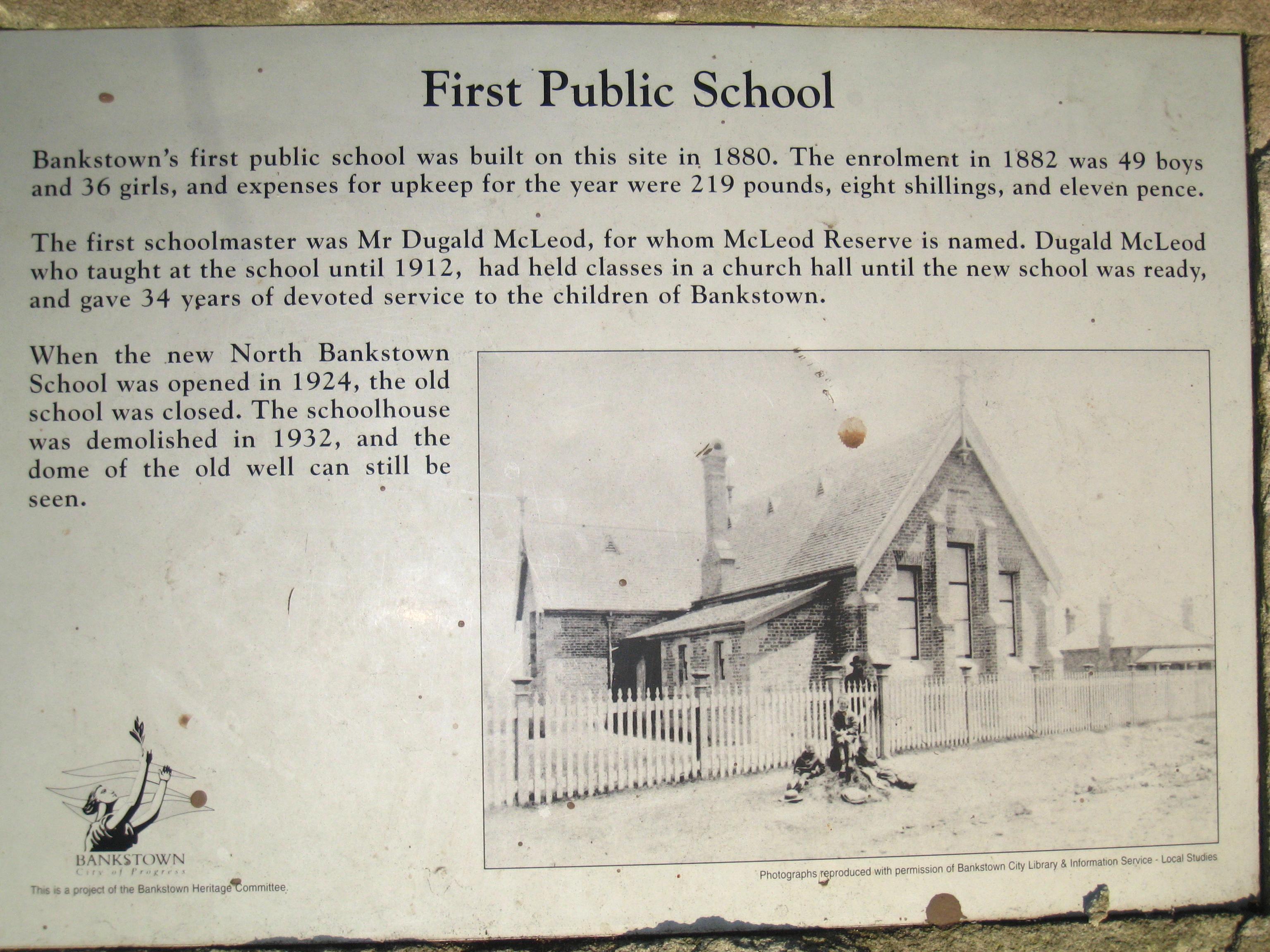
] Schools in Bankstown today include:* Bankstown Public School
* Bankstown South Infants School
* Bankstown Boys (Bankstown Senior College)
*Bankstown Girls High School
*Bankstown Grammar School
*Bankstown North Public School
*LaSalle Catholic College, Bankstown
*St Euphemia College
* Bankstown Community College
* TAFE Bankstown
* UWS Bankstown CampusParks and recreation
Major parks within Bankstown include
McLeod Reserve ,Bankstown Oval , Paul Keating Park and Bankstown City Gardens.'Bankstown City Gardens' were opened to the public in 1973. The park is on of the citys most picturesque sites. These gardens bring together many unusual types of flora found in Bankstown and beyond. The park is set on carefully landscaped grounds with walkways taking visitors through flowerbeds. The park consist of different areas, native, tropical, rose garden and Perennial. The park has also proven popular for wedding photographs. [http://commons.wikimedia.org/wiki/ ] '
] 'Paul Keating Park' was built on the site of Bankstown Council's former administration building, after it was destroyed by fire on 1 July 1997.Geology
Bankstown is situated in the Cumberland Plains region and is dominated by
Bringelly Shale in thenorth and Ashfieldshale in thesouth . Thearea south of Bankstown byGeorges River is dominated by Hawkesburysandstone where thesoil tends to beshallow ,sand y andinfertile .Population
Demographics
Bankstown has one of the most ethnically diverse communities in
Australia . Home to a large Lebanese community, Bankstown also boasts large populations of Chinese,Vietnam ese, Greek, Cypriot,Croatia n,Serbia n andMacedonian migrants. In all, over 60 different languages are spoken by the people of this suburb. Bankstown is considered as one of the most multicultural areas in the country.According to the 2006 Census, Bankstown had a population of 26,446. Just over half of Bankstown residents stated they had been born overseas, with Vietnam at 11.8 per cent the most common place of birth followed
Lebanon at 8.2 per cent, and China at 5.0 per cent.Census 2006 AUS | id = SSC11053 | name = Bankstown (State Suburb) | quick = on | accessdate = 2008-07-04 ]Census data reveals that after English,
Arabic is the most common 'language spoken at home' in Bankstown, used by 23.1 per cent, Vietnamese is spoken by 16.2 per cent, Chinese languages by 7.8 per cent (Mandarin 4.1% andCantonese 3.7%) and Greek by 3.8 per cent.According to the census,
Islam was the most followed faith in the suburb with 22.9 per cent of residents, just ahead ofCatholic s at 22.8 per cent.Buddhism with 11.9 per cent andEastern Orthodox with 9.7 per cent had the next largest followings.Notable residents
The following people are residents or former residents of Bankstown:
*Paul Keating , formerPrime Minister of Australia
*Ian Thorpe , swimmer
* The Waugh brothers:Steve Waugh and Mark, Australian Test cricket players
*Brett Holman , currentSocceroo also played for DutchEredivise clubNEC Nijmegen andBlackburn Rovers
*Terry Lamb ,Canterbury Bankstown Bulldogs and Australian Rugby League Test player
* Andrew and Michael Tierney from Human Nature
*Bryan Brown , Australian actor
*Vince Sorrenti , Australian comedian
* Casey Donovan, winner of the second "Australian Idol "
*Paulini Curuenavuli , finalist from the first "Australian Idol "Gallery
References
* Sue Rosen 1996, "Bankstown, a Sense of Identity"
External links
* [http://www.bankstowncity.nsw.gov.au/ Bankstown City Council Website]
* [http://www.id.com.au/bankstown/CommProfile/default.asp?id=101&gid=10&pg=1&bhcp=1 Community Profile]
* [http://www.abs.gov.au/ausstats/abs@census.nsf/Lookup2001Census/5BDD2CFAE6098391CA256BBE0083892A 2001 Census Information]
* [http://www.seo.nsw.gov.au/images/districts/region_metropolitan_big.jpgState Electoral Districts of NSW]
* [http://www.swsahs.nsw.gov.au/healthser/bnk/health/main.asp Bankstown Health Service]
* [http://www.travelmate.com.au/Places/Places.asp?TownName=Bankstown_%5C_NSW Travelmate - Bankstown, New South Wales]
* [http://www.yourrestaurants.com.au/nsw/sydney/bankstown/ Bankstown Restaurants]
* [http://www.uws.edu.au/about/locations/bankstown University of Western Sydney, Bankstown Campus]
* [http://www.bankstownairport.com.au/HOM010.asp Bankstown Airport]
* [http://www.tafensw.edu.au/campuses/location_3.htm TAFE NSW Bankstown College]
* [http://www.gws.org.au/cgi-bin/local_government.pl?form_type=showitem&documentid=990824999 Local Government Areas, Bankstown]
Wikimedia Foundation. 2010.