- Ottery, Cape Town
-
Ottery — Suburb — Street map of Ottery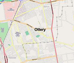 Location of Ottery in Cape Town
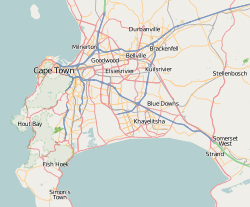
 Ottery
Coordinates: 34°00′53″S 18°30′16″E / 34.01472°S 18.50444°ECoordinates: 34°00′53″S 18°30′16″E / 34.01472°S 18.50444°E Country  South Africa
Province Western Cape Municipality City of Cape Town Wards 63, 66 Government[1] - Councillor Montgomery Oliver (Ward 63) (DA)
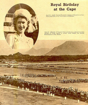
George March (Ward 66) (ID)Population (2001)[2] - Total 14,662 Ethnic groups - Black African 4.29% - Coloured 72.17% - Indian or Asian 4.61% - White 18.93% Languages - English 82.39% - Afrikaans 14.64% - Xhosa 1.79% Time zone SAST (UTC+2) Postal code 7750, 7780, 7800, 7941 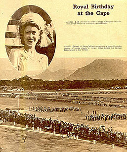 Queen Elizabeth II celebrated her 21st birthday at the Youngsfield aerodrome (now military base) in Ottery in 1947.
Ottery is a suburb in Cape Town, South Africa. It is on the edge of the Southern Suburbs. The Youngsfield Military Base, Royal Cape Golf Club and Cape Town's 'official' China Town are located in the suburb. Every year the Youngsfield Military Base in Ottery hosts the Cape Argust Junior Cycle Tour on the 12 of March.[3]
Contents
China Town
Launched in September 2008 the 'China Town' in Ottery is not a true Chinatown but is instead a 7500sq m retail park with 48, predominantly Chinese owned, retail units selling mostly Chinese imports. The retail park cost R45 million to construct.[4]
Geography
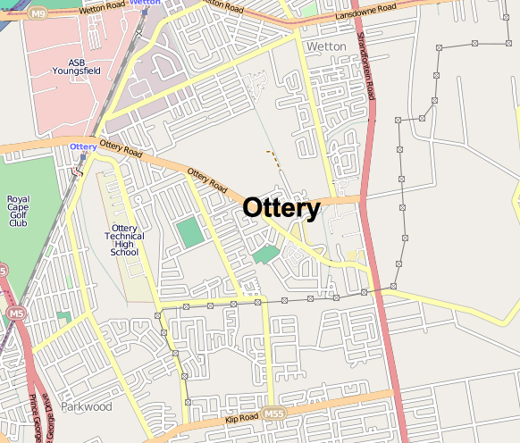
Ottery is bordered by Plumstead to the west, Philippi to the east and Kenilworth to the north west. The suburb can be accessed from the M5 freeway to the west of the suburb.
Eduction
Schools
- Nurul Adfaal pre-primary school
- Crystal House School (for learners with disabilities)
- Kids Kampus Pre School
- Ferndale Primary
- Junior College
Higher
- Ottery School of Industries
Medical
- Jafmed Clinic
- The Good Hope Medical Centre
Public Service
- The Ottery Traffic Department is one of Cape Towns major traffic control and testing centres
References
- ^ "Cape Town city Councillors by ward". City of Cape Town. http://web1.capetown.gov.za/web1/newcitycouncil/councilsearch.asp. Retrieved 25 July 2010.
- ^ "Ottery". Census 2001. City of Cape Town. http://www.capetown.gov.za/en/stats/2001census/Documents/Ottery.htm. Retrieved 2 July 2010.
- ^ Cape Argus Junior Cycle Tour. "Cape Argus Pick n Pay Junior Tour". http://www.juniorcycletour.co.za. Retrieved 3 March 2011.
- ^ Emily Purser (9 September 2008). "China Town retail park launched in Ottery". Cape Times (South Africa. http://www.highbeam.com/doc/1G1-184645259.html. Retrieved 3 March 2011.
Suburbs of Cape Town City Bowl Bo-Kaap · De Waterkant · Gardens · Higgovale · Oranjezicht · Schotsche Kloof · Tamboerskloof · University Estate · Vredehoek · Walmer Estate · Woodstock · ZonnebloemNorthern Suburbs Bellville · Bothasig · Brackenfell · Brooklyn · Durbanville · Edgemead · Elsie's River · Facreton · Goodwood · Kensington · Kuils River · Maitland · Monte Vista · Panorama · Parow · ThorntonAtlantic Seaboard Bantry Bay · Camps Bay · Clifton · Fresnaye · Green Point · Hout Bay · Llandudno · Mouille Point · Sea Point · Three Anchor BaySouthern Suburbs Bergvliet · Bishopscourt · Claremont · Constantia · Diep River · Heathfield · Kenilworth · Mowbray · Newlands · Observatory · Pinelands · Plumstead · Retreat · Rondebosch · Rondebosch East · Rosebank · Salt River · Steenberg · Tokai · WynbergSouth Peninsula Capri Village · Clovelly · Fish Hoek · Glencairn · Kalk Bay · Kommetjie · Masiphumelele · Muizenberg · Noordhoek · Ocean View · Scarborough · Simon's Town · St James · Sunnydale · Sun ValleyCape Flats Athlone · Belhar · Blue Downs · Bonteheuwel · Crawford · Crossroads · Delft · Elsie's River · Epping · Grassy Park · Gugulethu · Khayelitsha · Langa · Lansdowne · Lotus River · Manenberg · Mfuleni · Mitchell's Plain · Nyanga · Ottery · Philippi · WettonFalse Bay West Coast Categories:- Suburbs of Cape Town
- Western Cape geography stubs

Wikimedia Foundation. 2010.