- City Bowl
-
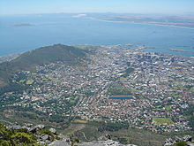
 The Cape Town city bowl as seen from Table Mountain. Robben Island is visible in Table Bay, Signal Hill is on the left, and Molteno dam can be seen in the centre.
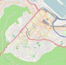
The City Bowl is a part of Cape Town in South Africa. It is a natural amphitheatre-shaped area bordered by Table Bay and defined by the mountains of Signal Hill, Lion's Head, Table Mountain and Devil's Peak.
The area includes the central business district of Cape Town, the harbour, the Company's Garden, and the residential suburbs of De Waterkant, Devil's Peak, District Six, Zonnebloem, Gardens, Higgovale, Oranjezicht, Schotsche Kloof, Tamboerskloof, University Estate, Vredehoek, Walmer Estate and Woodstock.
External links
Coordinates: 33°56′S 18°25′E / 33.933°S 18.417°E
Suburbs of Cape Town City Bowl Bo-Kaap · De Waterkant · Gardens · Higgovale · Oranjezicht · Schotsche Kloof · Tamboerskloof · University Estate · Vredehoek · Walmer Estate · Woodstock · ZonnebloemNorthern Suburbs Bellville · Bothasig · Brackenfell · Brooklyn · Durbanville · Edgemead · Elsie's River · Facreton · Goodwood · Kensington · Kuils River · Maitland · Monte Vista · Panorama · Parow · ThorntonAtlantic Seaboard Bantry Bay · Camps Bay · Clifton · Fresnaye · Green Point · Hout Bay · Llandudno · Mouille Point · Sea Point · Three Anchor BaySouthern Suburbs Bergvliet · Bishopscourt · Claremont · Constantia · Diep River · Heathfield · Kenilworth · Mowbray · Newlands · Observatory · Pinelands · Plumstead · Retreat · Rondebosch · Rondebosch East · Rosebank · Salt River · Steenberg · Tokai · WynbergSouth Peninsula Capri Village · Clovelly · Fish Hoek · Glencairn · Kalk Bay · Kommetjie · Masiphumelele · Muizenberg · Noordhoek · Ocean View · Scarborough · Simon's Town · St James · Sunnydale · Sun ValleyCape Flats Athlone · Belhar · Blue Downs · Bonteheuwel · Crawford · Crossroads · Delft · Elsie's River · Epping · Grassy Park · Gugulethu · Khayelitsha · Langa · Lansdowne · Lotus River · Manenberg · Mfuleni · Mitchell's Plain · Nyanga · Ottery · Philippi · WettonFalse Bay West Coast Categories:- Suburbs of Cape Town
- Western Cape geography stubs
Wikimedia Foundation. 2010.


