- Mouille Point
-
Mouille Point — Neighborhood — Country  South Africa
Province Western Cape Municipality City of Cape Town Wards Time zone SAST (UTC+2) Postal code 8005 
Mouille Point is an affluent suburb of Cape Town, situated between the V&A Waterfront to the North, Sea Point to the South and Green Point to the east. The suburb hugs the coastline, and consists primarily of high-end apartment blocks.
It is a very small suburb, having only two major roads (Beach Road and Bay Road). It is also home to the Mouille Point promenade; a paved promenade on the coast that is used daily by thousands of Capetonians. Behind it lies the Green Point Common, where numerous playing fields and a golf course are situated.
The name comes from the French word for anchoring ground. In the early 18th century, wrecks were common in Table Bay and the then governor decided that a breakwater (mouille in French) was needed to protect vessels. Work began in 1743. All farmers who delivered their goods to the city were required to load up their wagons with stones, drive out to Mouille Point and offload. Slaves and convicts were also used to build the breakwater, but after three years of labour and high seas, just 100m had been built and the project was abandoned. In 1781 the French arrived and built a battery near the unfinished mouille, naming it Mouille Point Battery.
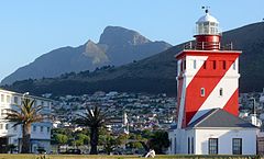
The Mouille Point lighthouse is prominently located here, but despite this, on 1 July 1966, during a fierce winter storm, a cargo ship, the S. A. Seafarer ran aground between Mouille Point and Three Anchor Bay. Everybody on board was rescued by helicopters of 17 squadron from AFB Ysterplaat.
For many years, opposite the lighthouse was a drive-in roadhouse, 'The Doll's House', where many people used to go for a snack and coffee during the day, or after a movie at night. The local seagulls were wise to this, and many a patron lost their sandwiches from the tray clipped to their window, to a robber gull that had landed on their car roof.
External Links
Suburbs of Cape Town City Bowl Bo-Kaap · De Waterkant · Gardens · Higgovale · Oranjezicht · Schotsche Kloof · Tamboerskloof · University Estate · Vredehoek · Walmer Estate · Woodstock · ZonnebloemNorthern Suburbs Bellville · Bothasig · Brackenfell · Brooklyn · Durbanville · Edgemead · Elsie's River · Facreton · Goodwood · Kensington · Kuils River · Maitland · Monte Vista · Panorama · Parow · ThorntonAtlantic Seaboard Bantry Bay · Camps Bay · Clifton · Fresnaye · Green Point · Hout Bay · Llandudno · Mouille Point · Sea Point · Three Anchor BaySouthern Suburbs Bergvliet · Bishopscourt · Claremont · Constantia · Diep River · Heathfield · Kenilworth · Mowbray · Newlands · Observatory · Pinelands · Plumstead · Retreat · Rondebosch · Rondebosch East · Rosebank · Salt River · Steenberg · Tokai · WynbergSouth Peninsula Capri Village · Clovelly · Fish Hoek · Glencairn · Kalk Bay · Kommetjie · Masiphumelele · Muizenberg · Noordhoek · Ocean View · Scarborough · Simon's Town · St James · Sunnydale · Sun ValleyCape Flats Athlone · Belhar · Blue Downs · Bonteheuwel · Crawford · Crossroads · Delft · Elsie's River · Epping · Grassy Park · Gugulethu · Khayelitsha · Langa · Lansdowne · Lotus River · Manenberg · Mfuleni · Mitchell's Plain · Nyanga · Ottery · Philippi · WettonFalse Bay West Coast Coordinates: 33°54′S 18°24′E / 33.9°S 18.4°E
Categories:- Suburbs of Cape Town
- Western Cape geography stubs


Wikimedia Foundation. 2010.