- North Williamstown railway station
-
North Williamstown 
Station information Code NWN Distance from
Flinders Street13.5 km Operator Metro Trains Melbourne Lines Williamstown # Platforms 2 # Tracks 2 Status Unmanned station Metlink profile Link Melway map Link Google map Link Metcard / Myki Zone Zone 1 North Williamstown is a railway station in Melbourne, Victoria, Australia, located in the suburb of Williamstown North, on the Williamstown railway line. North Williamstown is unmanned and is in Metcard Zone 1. It is 13.5 km from Flinders Street Station.
Contents
Station overview
Facilities
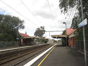
North Williamstown is located at the northern end of the Ferguson Street level crossing, with station access from Champion Road, Ferguson and Power Streets.
The station consists of two side platforms; Platform 1 has a large brick building, while platform 2 has a smaller brick building. A large Metcard ticket vending machine is located at the entrance to platform 1, which is able to dispense most ticketing options available and also accept notes and coins. A coin-only Metcard vending machine is located at the entrance to platform 2. Myki ticket vending machines are also located at the entrances to platform 1 & platform 2.
A pedestrian underpass is situated at the Williamstown end of the station, in addition to a crib crossing. The crossing is unusual as the local council provides a crossing guard to attend the pedestrian crossing before and after school, due to lack of automatic gates and the adjacent Williamstown North Primary School.[1]
The ARHS Railway Museum is a short walk from the station, along Champion Road.
History
North Williamstown station opened on 1 February 1859.[2] In 1993 a 12-year-old girl and her 10-year-old brother died when they crossed the tracks after a train had passed, and were hit by a train travelling in the opposite direction.[1]
Land east of the station was once occupied by a strip of historic commercial premises, but is now used as car parking. Various proposals have been made by railway land manager VicTrack to subdivide this land for a high-density residential development.[3]
Platforms, services and connecting bus services
Platform 1:
- Williamstown line - all stations services to Newport and Flinders Street.
Platform 2:
- Williamstown line - all stations services to Williamstown.
Gallery
References
- ^ a b "Push to act on ‘killer’ rail crossing". Star News Group. www.starnewsgroup.com.au. May 20, 2008. http://www.starnewsgroup.com.au/story/58831. Retrieved 2008-06-30.
- ^ VICSIG Infrastructure - North Williamstown
- ^ "Rail land may be sold". Star News Group. www.starnewsgroup.com.au. May 20, 2008. http://www.starnewsgroup.com.au/story/58833. Retrieved 2008-06-30.
Station Navigation Williamstown Line ← Previous Station Newport | Williamstown Beach Next Station → Entire network Melbourne's public transport - Metlink Modes and network Ticketing Metropolitan rail operators Regional rail operators Metropolitan and regional bus operators Broadmeadows Bus Service • Cardinia Transit • Cranbourne Transit • Driver Bus Lines • Dyson's Bus Services • Eastrans • East West Bus Company • Grenda's • Hope Street Bus Line • Invicta Bus Services • Ivanhoe Bus Company • Kastoria Bus Lines • Martyrs Bus Service • Melbourne Bus Link • McKenzie's • Moonee Valley • Moorabbin Transit • Moreland Buslines • NationalBus • Panorama Coaches • Peninsula Bus Lines • Portsea • Reservoir • Ryan Brothers Bus Service • Sita Buslines • Skybus Super Shuttle • Sunbury Bus Service • Tullamarine Bus Lines • US Bus Lines • Ventura Bus Lines • WestransPlanned infrastructure Authorities Coordinates: 37°51′26″S 144°53′20″E / 37.8573°S 144.8890°E
Categories:- Railway stations in Melbourne
- Railway stations opened in 1859
- Melbourne rail transport stubs

Wikimedia Foundation. 2010.