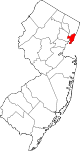
- New Durham, North Bergen
-
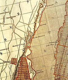 c 1840 New Durham left on map near Three Pigeons
New Durham is an area of North Bergen, New Jersey near the foot of Union Turnpike and Bergen Turnpike, and south of the Tonnelle Avenue Station of the Hudson Bergen Light Rail. It is one of the few residential areas along the otherwise industrial/commercial Tonnelle Ave, and site of one the town's main offices.[1] [2]

The area was site of the of colonial American community centered around the Three Pigeons when most of North Hudson was called Bergen Woods, a name recalled in Bergenwood Section on the steep slopes of the west side of the Hudson Palisades. Bergen Turnpike was one of the plank roads Hackensack Plank Road, crossing the Bergen Hill and the Hackensack Meadows that joined the village at Bergen Square with that at Hackenack that had been make the county seat of then much larger Bergen County in 1710. A congregation, established in 1800's, still uses the name for their church.[3][4]
New Durham was station stop on New York, Susquehanna and Western Railway's route into Pavonia Terminal, just north of the Susquehanna Transfer.[5][6]The Meadowview Section of North Bergen rises to the east of New Durham to the Municipal Building on Kennedy Boulevard. This neighborhood is nestled between the many cemeteries-Flower Hill Cemetery, Grove Church Cemetery, Hoboken Cemetery, Macphelah Cemetery and Weehawken Cemetery, that characterize the area and collectively constitute one of the largest green open spaces in otherwise densely populated North Hudson area.[7]
See also
- List of neighborhoods in North Bergen, New Jersey
- Maisland
Sources
- ^ North Bergen Post Office
- ^ Hudson County New Jersey Street Map. Hagstrom Map Company, Inc. 2008. ISBN 0-8809-7763-9.
- ^ New Durham Church
- ^ Barber, John W.; Howe, Henry, "North Bergen", Historical Collections of the State of New Jersey, New York: S. Tuttle, http://history.rays-place.com/nj/n-bergen-nj.htm
- ^ NYSW Stations
- ^ NYSW
- ^ Hudson County New Jersey Street Map. Hagstrom Map Company, Inc. 2008. ISBN 0-8809-7763-9.
Municipalities and communities of Hudson County, New Jersey Cities Bayonne | Hoboken | Jersey City | Union City
Borough Towns Guttenberg | Harrison | Kearny | Secaucus | West New York
Townships Coordinates: 40°47′07″N 74°01′58″W / 40.785379°N 74.032799°W
Categories:- North Bergen, New Jersey
- Neighborhoods in Hudson County, New Jersey
- New Jersey Meadowlands District
- Historic towns of Hudson County, New Jersey


Wikimedia Foundation. 2010.