- Narford
-
Coordinates: 52°41′36″N 0°36′41″E / 52.693196°N 0.611269°E
Narford 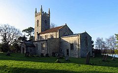
St Mary the Virgin, Narford
 Narford
Narford shown within NorfolkArea 9.70 km2 (3.75 sq mi) Population 41 UK census 2001 - Density 4 /km2 (10 /sq mi) OS grid reference TF764138 District Breckland Shire county Norfolk Region East Country England Sovereign state United Kingdom Post town KING'S LYNN Postcode district PE32 Police Norfolk Fire Norfolk Ambulance East of England EU Parliament East of England UK Parliament South West Norfolk List of places: UK • England • Norfolk Narford is situated in the Breckland District of Norfolk and covers an area of 970 hectares (3.75 square miles). Narford village has all but disappeared, with a population of only 41,[1] except for the large 18th century Narford Hall built by Andrew Fountaine, art collector and amateur architect.[2][3] To the rear of the hall runs the river River Nar on its way from West Acre towards Narborough. Adjacent to the hall is St.Mary the Virgin church[4] in the Benefice of Narborough and part of the Nar Valley Group of Parishes.
The late Andrew Fountaine (1918 to 1997) who was a founder member of the National Labour Party and deputy leader of the British National Front lived at Narford Hall. He retired from politics in 1981.[citation needed] He was the uncle, by marriage, to Tony Martin who was convicted of killing a 16 year old boy who broke into his house.[5]
The village is on the Nar Valley Way path.
In 1870-72, John Marius Wilson's Imperial Gazetteer of England and Wales described Narford.[6]
References
- ^ Census population and household counts for unparished urban areas and all parishes. Office for National Statistics & Norfolk County Council (2001). Retrieved 20 June 2009.
- ^ The Amateur Architect in England 1650 to 1850
- ^ A Genealogical and Heraldic History of the Commoners of Great Britain
- ^ The Parish Church of St Mary the Virgin
- ^ Guardian, Bleak world of the loner who killed
- ^ Wilson's Imperial Gazetteer
Categories:- Villages in Norfolk
- Breckland
- Civil parishes in Norfolk


Wikimedia Foundation. 2010.