- Didlington
-
Coordinates: 52°32′41″N 0°37′36″E / 52.544831°N 0.626654°E
Didlington 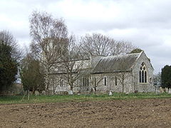
St Michael's church, Didlington
 Didlington
Didlington shown within NorfolkArea 11.07 km2 (4.27 sq mi) Population 48 (2001 census[1]) - Density 4 /km2 (10 /sq mi) OS grid reference TL7821097350 District Breckland Shire county Norfolk Region East Country England Sovereign state United Kingdom Post town Swaffham Postcode district IP26 Dialling code 01842 Police Norfolk Fire Norfolk Ambulance East of England EU Parliament East of England UK Parliament South West Norfolk List of places: UK • England • Norfolk Didlington is a village in the Breckland district of mid-Norfolk, East Anglia, England in the United Kingdom. It has an area of 11.07 km2 (4.27 sq mi) with a population of 48.[1]
The village is served by St.Michaels church in the Benefice of Cockley Cley.[2]
Neighbouring parishes 
Gooderstone
FouldenCockley Cley Hilborough Northwold 
Bodney  Didlington

Methwold Cranwich Ickburgh
MundfordReferences
- ^ a b "Census population and household counts for unparished urban areas and all parishes". Office for National Statistics & Norfolk County Council. 2001. http://www.norfolk.gov.uk/consumption/groups/public/documents/general_resources/ncc017867.xls. Retrieved 20 June 2009. (Excel XLS format)
- ^ Benefice of Cockley Cley
Categories:- Villages in Norfolk
- Civil parishes in Norfolk
- Norfolk geography stubs


Wikimedia Foundation. 2010.