- Narela
-
Not to be confused with Narela, Bhopal.
Narela — subdistrict — Coordinates 28°51′N 77°06′E / 28.85°N 77.1°ECoordinates: 28°51′N 77°06′E / 28.85°N 77.1°E Country India State Delhi District(s) North West Delhi Parliamentary constituency North West Delhi Assembly constituency Narela Civic agency Municipal Corporation of Delhi Time zone IST (UTC+05:30) Area
• 210 metres (690 ft)
Codes-
• Pincode • 110040
FootnotesNarela sub-city is a tehsil, located in the North West Delhi district of NCT of Delhi, and forms the border of the Delhi state with Haryana. Situated just off the Grand Trunk Road, its location made it an important market town for the surrounding areas, during 19th century, which it still retains. It was developed as the third mega sub-city project of Delhi Development Authority (DDA) in the urban extension project of Delhi, after Rohini Sub City and Dwarka Sub City.[1]and covering an area of 9866 ha.[2] The 'Narela Industrial Area', started developing in early 1980s and is today one of the important such complexes in Delhi. [3]
It is one of 12 zones of the Municipal Corporation of Delhi (MCD) [4] and one the three administrative divisions or subdistricts of the North West Delhi district, along with Saraswati Vihar and Model Town.[5]
Contents
History
There is a site in Narela Near Bhorgarh which dates back to the civilization of Harappa (Indus Valley Civilization). A Mound has been found with archaeological eveidence of painted gray ware pottery and other things.
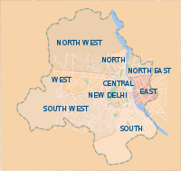 Districts of Delhi, with Narela in the North West Delhi district.
Sarai Narela was important sarai (caravan rest house) on the historic and ever busy Grand Trunk Road, that stretched all the way to Lahore and Kabul and the lifeline of the empire and important trade route.[6] Even in 13th century, during the days of Delhi Sultanate, Narela often became an encampment point, for marching or retreating armies from Delhi. [7] Subsequently, during the Mughal era, The Narela Sarai also finds mention in Jahangirnama, the official autobiography of Mughal Emperor, Jahangir (1569-1609), as he mentions staying at the sarai, during his travels ca. 1605.[8][9]
There is a famous pond (Talaab) in Narela and it remained full of water all the times. These days it has dried up and has been acquired by the DDA. From this pond some coins of the time of Mohammad Shah Rangila have been found.
On January 16, 1757 in the years preceding the Battle of Panipat (1761), the Maratha Army lead by Antaji Mankeshwar, fought with an advance column of Ahmad Shah Abdali's army near Narela, and repulsed it. [10]
In mid-19th century, Narela was a tehsil and flourishing market town, and at 31.2 km was the nearest town to capital Delhi, and where people from neighbouring villages flocked to buy provisions and sell their agricultural produce and its Narela Mandi (agricultural market), a tradition which continues to date. [11] By early 20th century, it was a municipal town and a Civil Hospital was established by the District Board in 1913. [12] After the World War I in 1919, Narela was declared a notified area by Delhi administration, earmarked for future development.[13]
In 1860-61, the North-Western Provinces education system was abolished in Delhi, and Punjab education system was introduced with opening of schools at Narela, Najafgarh, Mehrauli and their suburbs, several schools were opened here in the coming decades. [14] The Hailey-Rifah-i-Am School was founded here in 1918, by Rifah-i-Am Society formed by local residents under the patronage of Lala Mussadi Lal, a noted social reformer. By 1920-21, the society was running one middle school in Narela and two primary schools in Alipur and Kanjhawala and supported rural schools in Delhi Province.[15] Swami Omanand Saraswati, a local a zamindar and numberdar of villages, founded of Kanya Gurukul in Narela by donating his 70 acres (280,000 m2) of land at village.
Post-independence
After independence, Narela was still a satellite township of Delhi, separated from the built-up area of the Delhi city by several miles of green area. It functioned under separate local bodies, though soon it was to be part of the Metropolitan District of Delhi. Over the years, its population-density grew rapidly as Delhi saw a large influx of population as the result of partition. In 1961, Narela was incorporated into Municipal Corporation of Delhi zone.[16]
Narela Market was regularized in 1959, under the Bombay Agricultural Produce Marketing Act, 1939 [17], and in the 1960s, it had a jurisdictional radius of 5 miles, yet produce from at least 40 villages was brought into the market, despite octroi charges, thus the effective transactional radius was about 15 miles.[18] Thereafter under the Delhi Agricultural Produce Marketing Act, 1976, the first marketing committee of Narela was established by the Administrator of Delhi.[17]
In 1978, Delhi Industrial Development Corporation (DSIDC) started the development of 612 acres of land at Narela for establishing the industrial complex. The first phase saw the development of 1800 plots, the remaining 70 acres is earmarked for the next phase. The Industries Department, Govt. of Delhi in 2005, launched a scheme to convert built up plots of 350 square metres, within the complex from Lease Hold to Free Hold. [3]
Urban extension project
The project area is bounded by the Delhi-Haryana border in the North, Western Yamuna Canal in the West, GT Karnal road in the East and Badli-Auchandi Marg in the South East.
About 1000 ha land already acquired. More than 8000 residential flats of different categories have been constructed. About 1000 flats allotted to Delhi Police. About 900 plots of different sizes have been developed for alternative allotment/auction. Facility sites provided in Sector A7 & A8. IAMR complex of Planning Commission, GOI in 16 acres plot in Sector A7 functional. 200 bedded Raja Harish Chander Govt. Hospital in Sector A7 completed. Recreational club site has been proposed for development in sector A7.
Land allotted for DTC terminal. Land allotted for Fire station. Land for 80 m and 100 m roads from G.T. Karnal road (NH - 1) to Bawana industrial area has been acquired. Land proposed for National Science Park. Land for Integrated Freight Complex has been acquired. [2]
Administration
From 1993-2008, it was Delhi Legislative Assembly segment within the East Delhi Lok Sabha constituency, prior to it, Narela remained a 1966-93, a Delhi Metropolitan Council segment, with the same constituency.[19] After the delimitation of 2008, Narela (Nerela) is now an Assembly segment within the North West Delhi Lok Sabha constituency.[20]Presently Jaswant Singh of Congress I is the incumbent MLA from Narela constituency of Delhi Assembly, after the Delhi state assembly elections, 2008. [21]
The office of Sub Divisional Magistrate (SDM) (Narela), the head of Narela subdivision of North West Delhi district, is situated Block Development Officer (BDO) Office complex, at near by Alipur, which is within the subdivision, along with Sub Registrar Office.[5]
Geography
Timezone in Narela is Asia/Calcutta Sunrise at 07:12 and Sunset at 17:30. It's light Latitude. 28.85°, Longitude. 77.1°
Demographics
The total population of Narela, as per the 2001 Census is 501511. Of this, 0 are Scheduled Tribes (STs) and 99446 are Scheduled Caste (SC). The sex ratio of the population in Narela is 788 females per 1000 males.The literacy rate in the city is 78.46 per cent, 85.93 for males and 68.88 for females.
Accessibility
Its nearby towns are Alipur (9.9 km), Mukmelpur (10 km), Bawana (11.5 km) and Rāi (14.8 km)
Narela (NUR) is a station of Indian Railways. The nearest airport is Indira Gandhi International Airport (DEL), in Delhi at the distance of 42.2 km, while the Mundka station of Delhi Metro rail is the nearest station, though Narela sub city is part of the Delhi Metro's Master Plan Phase IV, currently underway.[22]
Areas in Narela Sub division
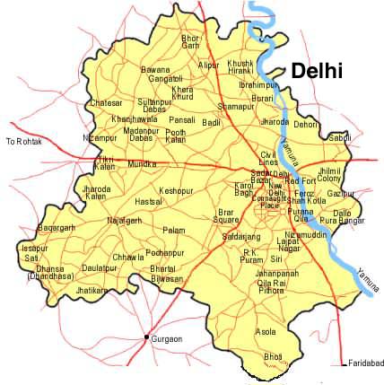
 Map of Delhi showing locations in Narela subdistrict
Akbarpur Majra, Alipur, Auchandi, Badli, Bajitpur Thakran, Bakhtawar Pur, Bakholi, Bankner, Barwala, Bawana, Bhorgarh, Budan Pur Bijapur, Daryapur Kalan, Fatehpur Jat, Bajeet Pur Thakran, Garhi Khasro, Gogha, Hamid Pur, Harevli, Hiranki, Holambi Kalan, Holambi Khurd, Ibrahimpur, Iradat Nagar (Naya Bans), Jhangola, Jind Pur, Katewra, Khampur, Khera Khurd, Kulakpur, Kureni, Lampur, Libas Pur, Mamur Pur, Mohamad Pur, Ramjan Pur, Mukhmail Pur, Mungesh Pur, Nangal Thakran, Nangli Poona, Narela, Palla, Pansali, Pehlad Pur Bangar, Pooth Khurd, Quadi Pur, Rajapur Kalan, Samai Pur, Sannoth, Shahabad Daulat Pur, Shahpur Garhi, Singhu, Siras Pur, Sultan Pur Dabas, Sunger Pur Ilaka Shahdara, Sungerpur Ilaka Delhi, Tajpur Kalan, Tehri Daulat Pur, Tiggi Pur, Tikri Khurd.[5]
References
- ^ "Urban Extension Projects:Narela". Delhi Development Authority. http://dda.org.in/planning/narela.htm.
- ^ a b "Delhi Masterplan 2021- Narela Urban Extension Project". Delhi Master Plan, Government of Delhi. September 17, 2011. http://delhi-masterplan.com/zonal-plans-mpd-2021/urban-extension-projects/narela.php.
- ^ a b "Narela Industrial Complex". Delhi Industrial Development Corporation (DSIDC). http://dsiidc.org/cms/Narela-Industrial-Complex.
- ^ Zones Municipal Corporation of Delhi.
- ^ a b c "North West District: Organisation Setup". Government of Delhi website. http://delhi.gov.in/wps/wcm/connect/doit_northwest/North+West+District/Home/Organisation+Setup.
- ^ Usha Masson Luther; Moonis Raza (1990). Historical routes of north west Indian Subcontinent, Lahore to Delhi, 1550s-1850s A.D.. Sagar Publications. p. 43.
- ^ Elliot, H. M. (Henry Miers), Sir; John Dowson (1871). The History of India, as Told by Its Own Historians. The Muhammadan Period (Vol 5.). London : Trübner & Co.. p. 4, 16. http://www.archive.org/stream/cu31924073036752#page/n17/mode/2up/search/Narela.
- ^ Jahangir. Tuzk-e-Jahangiri Vol. 1 (Jahangirnama). London Royal Asiatic Society. p. 58. http://persian.packhum.org/persian/main?url=pf%3Ffile%3D11001081%26ct%3D15%26rqs%3D922.
- ^ Subhash Parihar (2008). Land transport in Mughal India: Agra-Lahore Mughal highway and its architectural remains. Aryan Books International. p. 52. ISBN 8173053359.
- ^ Jaswant Lal Mehta (2005). Advanced study in the history of modern India 1707-1813. Sterling Publishers Pvt. Ltd.. p. 225. ISBN 1932705546. http://books.google.co.in/books?id=d1wUgKKzawoC&pg=PA225&dq=Narela&hl=en&ei=G5F8TvGiMYnSrQfL5dnTDw&sa=X&oi=book_result&ct=result&resnum=5&ved=0CEgQ6AEwBDgo#v=onepage&q=Narela&f=false.
- ^ Sudesh Nangia (1976). Delhi metropolitan region: a study in settlement geography. K.B. Publications. p. 147-148.
- ^ Rann Singh Mann (1979). Social structure, social change, and future trends: Indian village perspective. Rawat Publications. p. 215.
- ^ Vijendra K. R. V. Rao; P. B. Desai (1965). Greater Delhi: a study in urbanisation, 1840-1957. Asia Pub. House. p. 28. http://books.google.co.in/books?id=KDPRAAAAMAAJ&q=Narela&dq=Narela&hl=en&ei=zaV8TuyBOI3rrQfwlwE&sa=X&oi=book_result&ct=result&resnum=9&ved=0CE8Q6AEwCDgy.
- ^ Sharma, p. 18
- ^ Sharma, p. 141
- ^ A. Bopegamage (1957). Delhi, a study in urban sociology. University of Bombay. p. 31.
- ^ a b Uma Prasad Thapliyal (1987). Gazetteer of rural Delhi. Gazetteer Unit, Delhi Administration. p. 78. http://books.google.co.in/books?id=Jv21AAAAIAAJ&q=Narela&dq=Narela&hl=en&ei=vUJ8TvjuDcbSrQfU96XpDw&sa=X&oi=book_result&ct=result&resnum=3&ved=0CDsQ6AEwAjgK.
- ^ Market towns and spatial development in India. National Council of Applied Economic Research. 1965. p. 53.
- ^ "List of Parliamentary & Assembly Constituencies, General Election to the Lok Sabha, 2004". Government of Delhi website. http://www.delhi.gov.in/DoIT/DoIT_CEO/parliamentary.pdf.
- ^ "Delimitation of Parliamentary and Assembly Constituencies Order, 2008". The Election Commission of India. p. 556. http://eci.nic.in/eci_main/CurrentElections/CONSOLIDATED_ORDER%20_ECI%20.pdf.
- ^ "Members Of The Fourth Assembly". Delhi Legislative Assembly. http://delhiassembly.nic.in/aspfile/listmembers.htm.
- ^ "A Metro link for Narela Sub City". The Hindu. Jan 29, 2005. http://www.hindu.com/2005/01/29/stories/2005012912850400.htm.
- Ajay Kumar Sharma. A History of Educational Instituions in Delhi. Sanbun Publishers. ISBN 938021314X. http://books.google.co.in/books?id=TJPy-Kt8BrYC&pg=PA141&dq=Narela&hl=en&ei=vUJ8TvjuDcbSrQfU96XpDw&sa=X&oi=book_result&ct=result&resnum=5&ved=0CEIQ6AEwBDgK#v=onepage&q=Narela&f=false.
- Map of Narela tehsil
External links
Categories:- North West Delhi district
- Neighbourhoods of Delhi
- Delhi residential colonies
- Cities and towns in North West Delhi district
- District subdivisions of Delhi
-

Wikimedia Foundation. 2010.