- May 1981 tornado outbreak
-
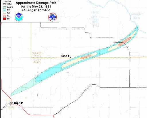
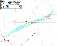 Path of the Binger, Oklahoma Tornado on May 22, 1981.
The May 1981 Tornado Outbreak was a tornado outbreak that occurred on May 22 in western and Central Oklahoma and on May 23 from eastern and central Oklahoma to central Iowa. 43 tornadoes were reported during the two-day outbreak, of which 14 were recorded as strong or violent (F2 or greater on the Fujita Scale). The outbreak claimed no fatalities and there were only 12 injuries from a tornado that touched down near Clinton, Oklahoma causing significant damage. The tornado outbreak overall left $32.8 million dollars (1981 USD) in damage.[1][2]
Contents
Storm history
On the morning of May 22, 1981, winds moving in from the south brought moist air across Texas and into western Oklahoma and dry line formed across the Texas panhandle. In addition, the interaction between a layer of warm air aloft and the return flow of moist air lead to widespread low clouds across the state of Oklahoma. Later that day, the low clouds broke as predicted by forecasters as the dry line moved east into western Oklahoma. However, the clearing was limited to a relatively narrow zone ahead of the dry line. Despite this, daytime heating allowed thunderstorms to form by mid-afternoon.[1]
Cordell Oklahoma tornado
The first tornado formed northwest of Cordell, Oklahoma at 4:17 pm (CDT). The tornado damaged a mobile home and several barns as it moved northeast over a six mile path. The tornado was photographed by a storm chaser team during a project conducted by the National Severe Storms Laboratory and Mississippi State University. Many storm chasers sometimes nicknamed the tornado the "Wizard of OZ" tornado because of its unusual shape.[1]
Binger tornado
A second thunderstorm formed south of the thunderstorm that produced the Cordell tornado. The second thunderstorm moved northeast, causing some concern among officials and forecasters as the storm was heading directly towards Oklahoma City. The second thunderstorm produced 6-12 tornadoes across a wide area stretching from Fort Cobb Reservoir to Union City. The thunderstorm later encountered cooler, less unstable air and dissipated near Oklahoma City.[1]
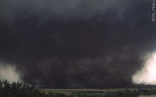 Photograph of the Binger Tornado
One of the group of the tornadoes, the Binger Tornado which touched down near Binger at 6:45 pm (CDT). At the time of formation, it was a weak F1 Tornado until it reached a point of 3.5 miles, west-southwest of the Scott Neighborhood community. At that point it strengthened and reach F4 status 1 mile east of the neighborhood. The tornado maintained that strength as it crossed Highway 37 until it dissipated near the Canadian River. Damage from the tornado was severe as it destroyed an old uninhabited house outside of Scott. Two other houses were also destroyed but their walls remained intact. A mile east, the tornado ripped the roof, walls and carport off another house while two more houses were completely destroyed. In addition the tornado uprooted or damaged several trees and flipped over automobiles and farm equipment during its 16 mile duration.[3]
Near Highway 37, the tornado blew away several storage tanks at an Amoco oil storage facility. One of the tanks, which was out of operation because of a lightning strike, was found 1500 ft south of its original location. The other two tanks blown away by the tornado were never found. A 1/2 mile away, the tornado destroyed a farmhouse and a barn and wrecked a pickup truck. Because the path of the Binger Tornado was mostly over unpopulated areas and due to early warnings and observations, there were no fatalities or injuries.[3]
Other tornadoes
After the Binger tornado dissipated, a complex of severe thunderstorms regenerated further west across west-central Oklahoma near Foss Reservoir. The thunderstorms produced at least five tornadoes, one of which affected the area around Clinton, Oklahoma causing 12 injuries. In Alfalfa, Oklahoma, two tornadoes were reported, one which did F2 Damage.[1][4] Thunderstorms along and east of a line from Oklahoma City, Kansas City and Omaha, Nebraska produced 29 tornadoes on May 23 across Oklahoma, Missouri, Kansas and Iowa. The same system travelled northwest and produced an F3 tornado that struck Bowl Bay, McCurdy Island on May 25.
Tornado table
Confirmed
TotalConfirmed
F0Confirmed
F1Confirmed
F2Confirmed
F3Confirmed
F4Confirmed
F543 15 14 11 2 1 0 Confirmed tornadoes
May 22, 1981 event
F# Location County Time (UTC) Path length Damage Oklahoma F2 N of New Cordell Washita 2217 6.9 miles
(11 km)F1 E of Lake Valley Washita 2325 1 miles
(1.6 km)F2 E of Cowden Washita, Caddo 0007 5 miles
(8 km)F1 SW of Arapaho Custer 0015 0.1 miles
(0.16 km)F0 W of Albert Caddo 0029 0.3 miles
(0.5 km)F2 N of Mountain View to W of Eakla Kiowa, Washita, Caddo 0030 15.4 miles
(24.6 km)F2 N of Stafford Custer 0030 10.4 miles
(16.6 km)F4 NE of Binger Caddo, Canadian 0049 16.7 miles
(26.7 km)F1 NW of Clinton Custer 0100 0.1 miles
(0.16 km)F1 NW of Union City Canadian 0132 2 miles
(3.2 km)F3 N of Clinton Custer 0155 10.3 miles
(16.5 km)F2 E of Greenfield Blaine 0340 unknown F1 NE of Cleveland Osage 0700 0.1 miles
(0.16 km)Kansas F0 N of Beverly Lincoln 2315 0.5 miles
(0.8 km)Minnesota F0 Moorhead Clay 2317 0.1 miles
(0.16 km)Source: Tornado History Project - May 22, 1981 Storm Data May 23, 1981 event
F# Location County Time (UTC) Path length Damage Iowa F0 S of Clarinda Page 2032 0.1 miles
(0.16 km)F0 SW of Grant Montgomery 2032 0.1 miles
(0.16 km)F0 W of Canby Adair 2115 0.1 miles
(0.16 km)F0 NE of Anita Cass 2130 0.1 miles
(0.16 km)F0 E of Canby Adair 2202 0.1 miles
(0.16 km)F0 N of Arbor Hill Adair 2215 0.1 miles
(0.16 km)F0 S of Dexter Madison 2236 0.1 miles
(0.16 km)F2 SW of Beaconsfield Ringgold 2300 15.9 miles
(25.4 km)F1 SE of Earlham Madison 2328 0.1 miles
(0.16 km)F2 W of Osage Mitchell 2355 3.8 miles
(6.1 km)Oklahoma F1 E of Bristow Creek 2100 0.1 miles
(0.16 km)F1 NW of Hoover Garvin 2200 2 miles
(3.2 km)F0 NW of Lenapah Noata 2230 0.1 miles
(0.16 km)F1 Sulphur area Murray 2305 0.1 miles
(0.16 km)F1 SW of McLoud Pottawatomie 2325 0.1 miles
(0.16 km)F1 SE of Aydelotte Pottawatomie 2330 0.1 miles
(0.16 km)F2 NE of Copan Washington, Nowata 2330 15.2 miles
(24.3 km)F2 NW of Elliot Nowata 2335 4.5 miles
(7.2 km)F3 Durant area Bryan 0058 9.7 miles
(15.5 km)F1 SW of Sasakwa Bryan 0100 0.1 miles
(0.16 km)F2 E of Colcord Delaware 0118 unknown Kansas F0 NW of Wallula Leavenworth 2115 2 miles
(3.2 km)F2 W of Scipio Anderson 2115 1.5 miles
(2.4 km)F1 S of Centerville Linn 2215 2 miles
(3.2 km)F0 E of Coffeyville Montgomery 2325 0.5 miles
(0.8 km)F1 SW of Valeda Montgomery 2340 0.5 miles
(0.8 km)Missouri F0 W of Ferrelview Platte 2153 3.8 miles
(6.1 km)F0 N of Nevada Vernon 2355 0.5 miles
(0.8 km)Source: Tornado History Project - May 23, 1981 Storm Data See also
References
- ^ a b c d e Mike Branick (2006). "A Look Back on the Tornado Outbreak in Oklahoma on 22 May 1981--The Binger Tornado". NOAA. http://www.srh.noaa.gov/oun/newsletter/spring2006/spring2006.pdf. Retrieved 2006-10-27.
- ^ NCDC (1981). "Oklahoma event details". NOAA. http://www4.ncdc.noaa.gov/cgi-win/wwcgi.dll?wwevent~storms. Retrieved 2006-10-27.
- ^ a b Dr. James R. McDonald, Dr. H. Scott Norville, and Timothy P. Marshall (2006). "DAMAGE SURVEY OF THE BINGER, OKLAHOMA TORNADO OF MAY 22, 1981". National Severe Storms Laboratory. http://www.stormtrack.org/library/damage/binger.htm. Retrieved 2006-10-27.
- ^ NSSL (2006). "Public Domain Tornado Images". http://www.spc.noaa.gov/faq/tornado/torscans.htm. Retrieved 2006-10-27.
Categories:- F4 tornadoes
- Tornadoes of 1981
- Tornadoes in Oklahoma
- 1981 in the United States

Wikimedia Foundation. 2010.