- Mahlsdorf
-
"Berlin-Mahlsdorf" redirects here. For the railway station, see Berlin-Mahlsdorf station
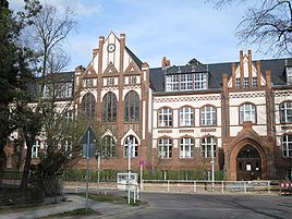
Mahlsdorf Quarter of Berlin Friedrich Schiller elementary school 
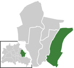
Coordinates 52°30′22″N 13°36′54″E / 52.50611°N 13.615°ECoordinates: 52°30′22″N 13°36′54″E / 52.50611°N 13.615°E Administration Country Germany State Berlin City Berlin Borough Marzahn-Hellersdorf Quarter subdivisions 2 zones Basic statistics Area 12.9 km2 (5.0 sq mi) Elevation 50 m (164 ft) Population 26,852 (31 December 2009) - Density 2,082 /km2 (5,391 /sq mi) Founded 1753 Other information Time zone CET/CEST (UTC+1/+2) Licence plate B Postal codes (nr. 1004) 12623 Website Official website Mahlsdorf is a locality (Ortsteil) within the Berlin borough (Bezirk) of Marzahn-Hellersdorf. Until 2001 it was part of the former borough of Hellersdorf.
Contents
History
The locality was mentioned for the first time in a document of 1345, named as Malterstorp. Until 1920 it was a municipality of ther former Niederbarnim district, merged into Berlin with the "Greater Berlin Act" [1].
Geography
Overview
Mahlsdorf is located in the eastern suburb of Berlin, at the borders with the Brandenburger district of Märkisch-Oderland. It is bounded by the municipality of Neuenhagen and Hoppegarten, with its hamlets Hönow, Waldesruh and Birkenstein. The Berliner bordering localities are Hellersdorf, Kaulsdorf and Köpenick (in Treptow-Köpenick district). In the south of the quarter there are the lakes Eisensee and part of the Habermannsee, divided with Kaulsdorf.
Subdivision
Mahlsdorf is divided into 2 zones (Ortslagen):
- Mahlsdorf-Nord
- Mahlsdorf-Süd
Transport
The locality, crossed by the federal highways B1 and B5, is served by the S-Bahn line S5, at the rail station of Mahlsdorf. Birkenstein station, situated in the homonymous hamlet of the town of Hoppegarten, is close to the eastern suburb of the quarter.
Photogallery
Personalities
- Gerhard Behrendt (1929-2006)
- Ralf Bursy (b, 1956)
- Alice Herz (1882-1965)
- Charlotte von Mahlsdorf (1928-2002)
- Kathrin Schmidt (b. 1958)
- Kurt Schwaen (1909-2007)
- Reiner Süß (b. 1930)
- Petra Zieger (b. 1959)
References
- ^ (German) Historical infos about Mahlsdorf
Literature
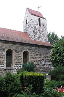
- Kurt Pomplun: "Berlins alte Dorfkirchen" (page 59). Verlag Bruno Hessling, Berlin 1967
External links
 Media related to Mahlsdorf at Wikimedia Commons
- (German) Mahlsdorf official website
Districts and localities of Berlin  Charlottenburg-Wilmersdorf
 Friedrichshain-Kreuzberg
 LichtenbergAlt-Hohenschönhausen • Falkenberg • Fennpfuhl • Friedrichsfelde • Karlshorst • Lichtenberg • Malchow • Neu-Hohenschönhausen • Rummelsburg • Wartenberg
 Marzahn-Hellersdorf
 Mitte
Mitte Neukölln
 PankowBlankenburg • Blankenfelde • Buch • Französisch Buchholz • Heinersdorf • Karow • Niederschönhausen • Pankow • Prenzlauer Berg • Rosenthal • Stadtrandsiedlung Malchow • Weißensee • Wilhelmsruh
 ReinickendorfFrohnau • Heiligensee • Hermsdorf • Konradshöhe • Lübars • Märkisches Viertel • Reinickendorf • Tegel • Waidmannslust • Wittenau
 SpandauFalkenhagener Feld • Gatow • Hakenfelde • Haselhorst • Kladow • Siemensstadt • Spandau • Staaken • Wilhelmstadt
 Steglitz-Zehlendorf
 Tempelhof-Schöneberg
 Treptow-KöpenickAdlershof • Alt-Treptow • Altglienicke • Baumschulenweg • Bohnsdorf • Friedrichshagen • Grünau • Johannisthal • Köpenick • Müggelheim • Niederschöneweide • Oberschöneweide • Plänterwald • Rahnsdorf • Schmöckwitz
Districts > Localities > Zones • Greater Berlin Act • Former boroughs Categories:- Populated places established in 1753
- Localities of Berlin
- Marzahn-Hellersdorf
Wikimedia Foundation. 2010.


