- Maghreb highway
-

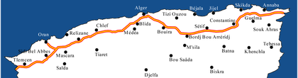
The Maghreb highway (in arab: الطريق السيارة المغاربية) is a highway through the Magreb territory (passing in Mauritania, Morocco, Algeria, Tunisia, Libya). The highway is made up of an Atlantic main road (from Nouakchott to Rabat), and a Mediterranean main road (from Rabat to Tripoli).
Contents
Detailed route
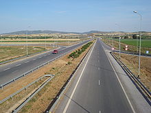
Moroccan part
- Agadir-Casablanca (480 km - 2010)
- Casablanca-Rabat (90 km - 1987)
- Rabat-Fès (182 km - 1999)
- Fès-Oujda (328 km - 2011)
Algerian part
 Algerian part
1216 kilometers in Algeria from the Moroccan border to the Tunisian border (via Tlemcen, Oran, Chlef, Alger, Sétif, Constantine, Annaba et 16 others wilayas) :
- Morocco-Algeria border to Chlef (365 km via Tlemcen and Oran planned for 2010)
- Chlef-Bordj Bou Arreridj (435 km via Alger planned for 2010)
- Bordj Bou Arreridj to Algeria-Tunisia border (365 km via Sétif, Constantine and Annaba planned for 2011)
Tunisian part
 Tunis-Beja motorway
Algerian border-Tunis (207 km) :
- Algeria-Tunisia border to Bousalem (70 km prévue en 2020) with 2 exits to Jendouba and Tabarka
- Bousalem-Oued Zarga (70 km planned for 2016) with an express way to Béja
- Oued Zarga-Medjez el-Bab-Tunis (67 km February 2006)
Tunis-lybian border (573 km) :
- Tunis-Hammamet (51 km 1986)
- Hammamet-M'saken (92 km March 1994) with an exit to Sousse
- M'saken-Sfax (97 km juillet 2008) with an exit to Mahdia
- Sfax-Gabès (151 km planned for 2011)
- Gabès to Tunisia-Libya border (182 km planned for 2024)
Libyan part
- 200 kilometers for Libya linking the Tunisia-Libya border to Tripoli tuniso-libyenne à Tripoli.
The Libyan part will be made in partnership with Italia, the delivery is planned for 2014.
Categories:- Full access controlled highways
- Maghreb


Wikimedia Foundation. 2010.