- Dandenong railway station
-
Dandenong 
Station information Code DNG Distance from
Flinders Street30 km Operator Metro Trains Melbourne Lines Bairnsdale,
Cranbourne,
Pakenham# Platforms 3 # Tracks 3 (9 including freight) Status Premium station Metlink profile Link Melway map Link Google map Link Metcard / Myki Zone 2 Dandenong is a railway station located in Dandenong, Victoria, Australia. Located 30 km from Flinders Street Station in central Melbourne, the station serves as the junction of the Pakenham and Cranbourne railway lines, and is the terminus station for several peak services. It also serves V/Line trains along the Traralgon and Bairnsdale lines.
Contents
Station overview
Facilities
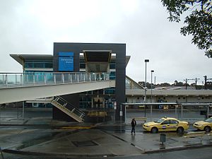
Dandenong station is located on Foster Street, adjacent to the Dandenong central business district as well as a housing development known as Metro 3175. The station is part of Metcard Zone Zone 2, and as a Premium Station it is staffed from first train to the last each day.
The current design has a bright yellow overpass attached to three platforms, with lifts to each platform and a ramp from the street, making it wheelchair accessible. A number of train stabling sidings are near the station, as is a little used goods yard to the south of the station.
Stabling facilities are provided on the City side of the station on either side of the track, but trains can also be stabled on tracks parallel to the platforms.
History
Dandenong station was first opened in 1877 as one of the original stations on the Melbourne to Sale railway line. The South Gippsland Railway Line opened in 1892 from Dandenong. The station buildings was reconstructed in 1975,[1] and again in 1994-1995, as part of the $27 million Federal Government funded Cranbourne electrification project.[2] The new station opened in March 1995.[3]
A third rail line is to be built connecting the station with Caulfield railway station as part of the $1 billion Dandenong railway line triplication project.[4]
Platforms
Platforms 1, 2 and 3:
- Metro Trains services towards Flinders Street.
- Metro Trains services towards Cranbourne and Pakenham.
- V/Line Gippsland line services towards Southern Cross Station (not picking up passengers).
- V/Line Gippsland line services towards Warragul and Traralgon. Some services extend to Sale and Bairnsdale (not setting down passengers).
References
- ^ Vincent Adams Winter (1990). VR and VicRail: 1962 - 1983. p. 106. ISBN 0 9582069 3 3.
- ^ Fiddian, Mark (1997). Trains, Tracks, Travelers. A history of the Victorian Railways. South Eastern Independent Newspapers. p. 154. ISBN 1 875475 12 5.
- ^ "Upgrading Eltham to a Premium Station". Newsrail (Australian Railway Heritage Society (Victorian Division)): page 310. October 1997.
- ^ Department of Infrastructure website
Station Navigation Metropolitan service Pakenham line ← Previous Station Yarraman | Hallam Next Station → Cranbourne line ← Previous Station Yarraman | Merinda Park Next Station → V/Line service Traralgon and Bairnsdale lines ← Previous Station Caulfield | Pakenham Next Station → Entire metropolitan network Entire V/Line network The closed General Motors station is located towards Hallam station on the Pakenham line, and the proposed Lynbrook station is located towards Cranbourne, as is the freight only Lyndhurst station.
Melbourne's public transport - Metlink Modes and network Ticketing Metropolitan rail operators Regional rail operators Metropolitan and regional bus operators Broadmeadows Bus Service • Cardinia Transit • Cranbourne Transit • Driver Bus Lines • Dyson's Bus Services • Eastrans • East West Bus Company • Grenda's • Hope Street Bus Line • Invicta Bus Services • Ivanhoe Bus Company • Kastoria Bus Lines • Martyrs Bus Service • Melbourne Bus Link • McKenzie's • Moonee Valley • Moorabbin Transit • Moreland Buslines • NationalBus • Panorama Coaches • Peninsula Bus Lines • Portsea • Reservoir • Ryan Brothers Bus Service • Sita Buslines • Skybus Super Shuttle • Sunbury Bus Service • Tullamarine Bus Lines • US Bus Lines • Ventura Bus Lines • WestransPlanned infrastructure Authorities Coordinates: 37°59′24″S 145°12′35″E / 37.9900°S 145.2098°E
Categories:- Railway stations in Melbourne
- Premium Melbourne railway stations
- Railway stations opened in 1877
- Melbourne rail transport stubs

Wikimedia Foundation. 2010.