- Cranbourne railway line
-
Cranbourne railway line, Melbourne 
Line details Completed 1886 Length 14 km (8.7 mi) Stations 2 Tracks Single track with crossing loops Used by Metro Trains Melbourne, Pacific National cement trains Service pattern Stopping all stations Rolling stock Hitachi, Comeng Connections Pakenham Former connections South Gippsland Railways in Melbourne List of stations
Freight railways
Closed railways
Proposed railwaysThe Cranbourne railway line is a suburban electric railway service operated by Metro Trains Melbourne in the south-eastern suburbs of Melbourne, Australia. It operates along the inner section of the former South Gippsland line.
Contents
Description
The line traverses flat country and there is little in the way of earthworks. There are several level crossings along the line. The area around Cranbourne is one of Melbourne's main growth areas, giving the line considerable potential for growing patronage.
Infrastructure
The line, which branches from the Pakenham line at Dandenong, is single track throughout, with a crossing loop towards the Cranbourne end of the line. Trains can also cross at Cranbourne itself, which has two platforms. Power signalling is provided throughout, being controlled from Dandenong. There are no intermediate terminating facilities, however stabling sidings were recently constructed and opened in Cranbourne.
Beyond Cranbourne there is a siding between Cameron Street and Berwick-Cranbourne Road near the Cranbourne "Shed" and the new Hunt Club Estate. The line then continues to Leongatha, but between Cranbourne and Nyora, the line is unserviceable. Government plans have the line to Leongatha being rebuilt and reopened, but there appears to be little happening in this regard.
Services
- Cranbourne, Merinda Park, Dandenong, all stations to Caulfield/Malvern, express to South Yarra, then all stations to Flinders Street via City Loop. Services before 6:30am and after 8:30pm are shuttle services between Cranbourne and Dandenong. A small number of peak hour services stop all stations.
The only freight traffic was cement traffic from Waurn Ponds near Geelong to Lyndhurst, this ended in 2009 after Pacific National increased the costs charged to Blue Circle Southern.[1]
History
The Cranbourne line opened in December 1886 as part of the section to Tooradin. This was the first section of the South Gippsland Railway, with passenger services to Leongatha withdrawn on 24 July 1993. The last train ran on the 24 July 1993 with P class locomotive hauling an FSH set to Leongatha and back to Melbourne.[2]
In November 1993, Train Order Working replaced Electric Staff safeworking to Cranbourne, then on 24 March 1995, the electrification and power signalling on the Cranbourne line was commissioned. Funded as part of the Federal Government ‘Building Better Cities’ program,[3] the $27 million project included an upgraded Dandenong station and a new Merinda Park station at Cranbourne North[4] (the line had previously been electrified for a short distance to the Commonwealth Engineering siding).
The last regular train running though and beyond Cranbourne was on 16 January 1998, when the AGM Siding (near Nyora) to Spotswood station sand train ceased operation.[5]
In 2008, work started on the construction of six train stabling sidings at Cranbourne station at a cost of $37 million, to enable more trains to run on the line at peak times without duplicating the line,[6][7] which was completed in November the same year, along with a major upgrade of the station and the extension of platform 2.
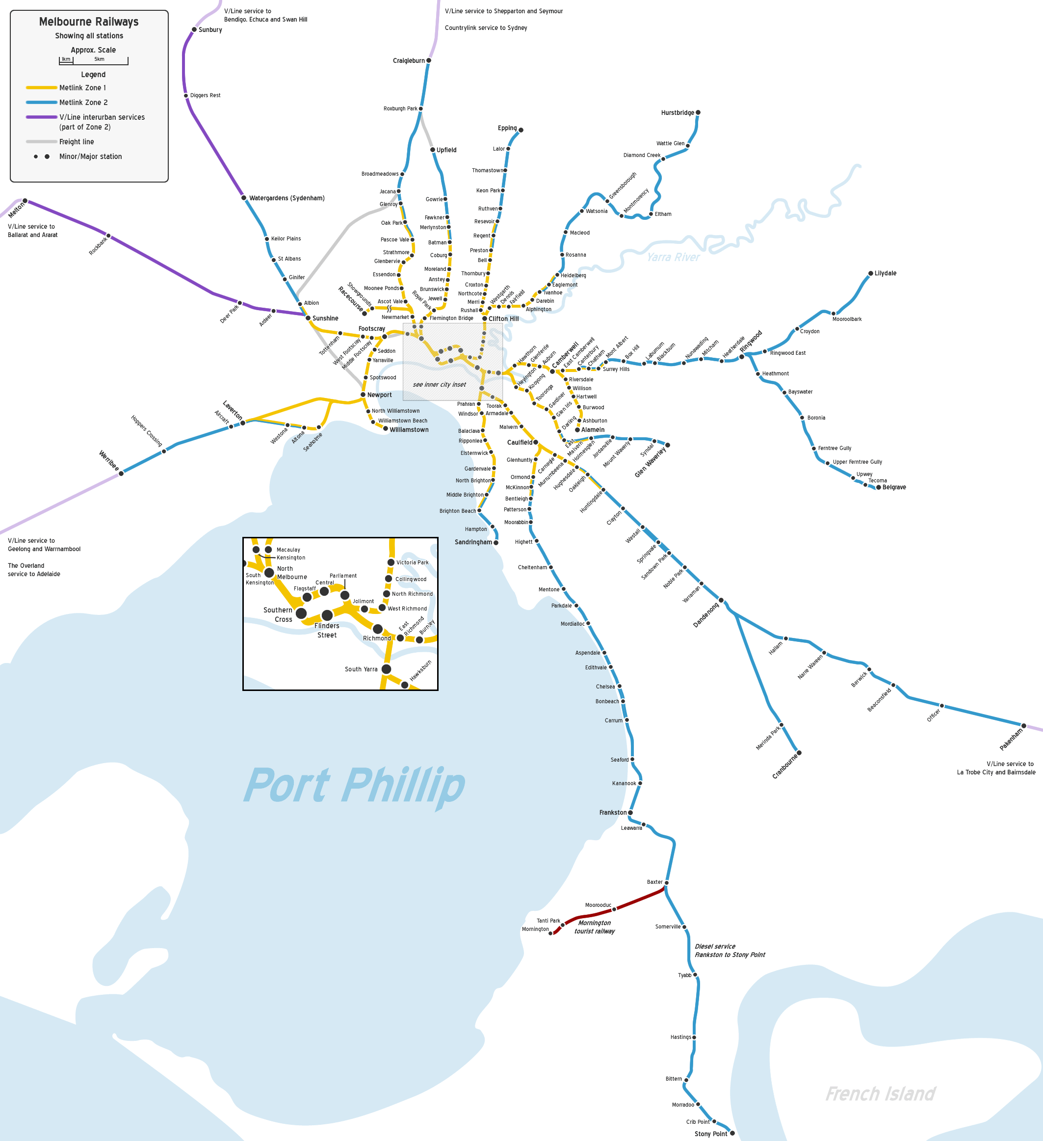
Line guide
Bold stations are terminuses, where some train services terminate; italic stations are staffed.
Branches from the Pakenham line at Dandenong.
Cranbourne Line Legend


0.0 km Flinders Street (FSS) Zone 1 

City Loop 
2.4 km Richmond (RMD) Zone 1 
Burnley group 
City Link 
Yarra River 4.2 km South Yarra (SYR) Zone 1 
Sandringham line 
5.4 km Hawksburn (HKN) Zone 1 6.7 km Toorak (TOR) Zone 1 7.4 km Armadale (ARM)* Zone 1 8.9 km Malvern (MAL)* Zone 1 10.6 km Caulfield (CFD) Zone 1 Frankston line 12.3 km Carnegie (CNE)* Zone 1 13.2 km Murrumbeena (MRB)* Zone 1 

Outer Circle line 14.2 km Hughesdale (HUG) Zones 1 & 2 
Rosstown Railway 
15.4 km Oakleigh (OAK) Zones 1 & 2 17.0 km Huntingdale (HUN)* Zones 1 & 2 19.2 km Clayton (CLA) Zone 2 21.4 km Westall (WTL) Zone 2 23.3 km Springvale (SPG) Zone 2 
Springvale Cemetery Line 24.4 km Sandown Park (SNP) Zone 2 25.1 km Noble Park (NPK)* Zone 2 
Mile Creek 27.8 km Yarraman (YMN) Zone 2 
EastLink Yarraman Creek 30.0 km Dandenong (DNG) Zone 2 Dandenong Creek Pakenham line Eumemmerring Creek 
38.362 km Lyndhurst (Formerly for freight, now closed) 

Lynbrook loop 
39.3 km Lynbrook (Under Construction) Zone 2 

42.5 km Merinda Park (MPK) Zone 2 
44.0 km Cranbourne (CBE) Zone 2 
? km Cranbourne East (Proposed) Zone 2 
South Gippsland line References
- ^ Daniel Breen (24 March 2009). "Freight network goes off the rail". Geelong Advertiser. www.geelongadvertiser.com.au. http://www.geelongadvertiser.com.au/article/2009/03/24/58345_news.html. Retrieved 4 April 2009.
- ^ Chris Banger (March 1997). "Rail Passenger Service Withdrawals Since 1960". Newsrail (Australian Railway Historical Society (Victorian Division)): pages 77–82.
- ^ Lyndsay Neilson. "Appendix 1: Funding Allocation, Victorian Area Strategies". The ‘Building Better Cities’ program 1991-96: a nation-building initiative of the Commonwealth Government. epress.anu.edu.au. http://epress.anu.edu.au/anzsog/auc/mobile_devices/ch08s15.html#d0e3496. Retrieved 2010-11-01.
- ^ Fiddian, Mark (1997). Trains, Tracks, Travelers. A history of the Victorian Railways. South Eastern Independent Newspapers. p. 154. ISBN 1 875475 12 5.
- ^ "Farewell – The Sand Train". Newsrail (Australian Railway Historical Society (Victorian Division)): pages 71–76. February 1998.
- ^ "Media Release: CRANBOURNE STATION TRAIN STABLING PROJECT ON TRACK". Minister for Public Transport Media Release. www.dpc.vic.gov.au. http://www.dpc.vic.gov.au/domino/Web_Notes/newmedia.nsf/955cbeae7df9460dca256c8c00152d2b/16a31250939e85d6ca257410007a9d5b!OpenDocument. Retrieved 24 April 2008.
- ^ "VICSIG – Infrastructure – Cranbourne Sidings and Station". www.vicsig.net. http://www.vicsig.net/index.php?page=infrastructure&project=cbesidings. Retrieved 24 April 2008.
External links
- Timetables
- Official line map
- Network map
- Statistics and detailed schematic map at the VicSig enthusiast website
Railway Lines in Victoria Main lines
Bendigo Line · Mildura line · North East Line · (Melbourne-Sydney) · Orbost Line · Port Fairy Line · Portland line · Serviceton Line · South Gippsland Line · Tocumwal line · Western SG line (Melbourne-Adelaide)Branch linesAlexandra line · Alvie line · Balranald line · Bolangum line · Briagolong line · Bright line · Buninyong line · Carpolac line · Casterton line · Cobram line · Cohuna line · Coleraine line · Cudgewa line · Daylesford line · Deniliquin line · Forrest line · Grampians line · Heathcote line · Kulwin line · Lancefield line · Maffra line · Mansfield line · Mortlake line · Mirboo North line · Navarre line · Noojee line · Oaklands line · Outtrim line · Patchewollock line · Peechelba East line · Picola line · Portland line · Redesdale line · Red Hill line · Robinvale line · Skipton line · Strzelecki line · Stony Crossing line · Tatong line · Thorpdale line · Timboon line · Wahgunyah line · Waubra line · Wedderburn line · Wonthaggi line · Woodside line · Yackandandah line · Yanac line · Yaapeet line ·
Cross Country linesAvoca line · Geelong-Ballarat line · Eaglehawk–Inglewood line · Moolort Line · Toolamba–Echuca line
V/Line servicesGeelong Line · Warrnambool Line · Ballarat Line · Maryborough Line · Ararat Line · Bendigo Line · Swan Hill Line · Echuca Line · Seymour Line · Shepparton Line · Albury-Wodonga Line · Traralgon Line · Bairnsdale Line
Melbourne suburban servicesCity Loop · Werribee line · Williamstown line · Sydenham line · Craigieburn line · Flemington Racecourse line · Upfield line · Epping line · Hurstbridge line · Lilydale line · Belgrave line · Alamein line · Glen Waverley line · Pakenham line · Cranbourne line · Frankston line · Stony Point line (unelectrified) · Sandringham line
Inner Circle line · Outer Circle line · Rosstown Railway · St Kilda - Windsor line · Spring Vale Cemetery line · Mont Park line · Kew line · Red Hill line · Whittlesea line · Warburton line · Mornington line · Healesville line · St Kilda line · Port Melbourne line Tourist railwaysNarrow gauge branch linesWhitfield line · Gembrook line · Crowes line · Walhalla line
Melbourne goods linesNewport-Sunshine line · Albion-Jacana line · South Kensington-West Footscray line
Categories:- Railway lines in Melbourne
- Railway lines opened in 1886
Wikimedia Foundation. 2010.