- Pakenham railway line
-
Pakenham railway line, Melbourne 
Line details Commenced 1877 Completed 1879 Length 56.9 km (35.4 mi) Stations 29 (via Loop) Tracks Quadruplicated to Caufield, remainder double track Used by Metro Trains Melbourne, V/Line and freight to Gippsland Service pattern Stopping all stations, some Rolling stock Hitachi, Comeng, Siemens Connections Sandringham, Frankston, and Cranbourne lines Former connections Rosstown Railway, Outer Circle, and Spring Vale Cemetery lines Railways in Melbourne List of stations
Freight railways
Closed railways
Proposed railwaysThe Pakenham railway line in Melbourne, Australia is the suburban electrified portion of the railway to Bairnsdale in eastern Gippsland. In addition to suburban electric trains, it carries diesel passenger trains and freight trains to Gippsland.
Contents
Description
The Pakenham line traverses mainly flat country with few curves and fairly minimal earthworks for most of the line. However between South Yarra and Malvern the line has been lowered into a cutting to eliminate level crossings, and between Malvern and Caulfield it has been raised on an embankment for the same reason. Also, it encounters some gentle hills between Narre Warren and Beaconsfield which require some more extensive earthworks to negotiate. After Caulfield, the line has numerous level crossings, as well as some bridges over and under roads.
Most of the line goes through built-up suburbs and some industrial areas, but after Dandenong, it gets into more open countryside, passing by open fields and farms, particularly after Beaconsfield. This outer portion of the line is one of Melbourne's main growth corridors, which is rapidly replacing the farms with houses and adding many new riders to the line each year.
Infrastructure
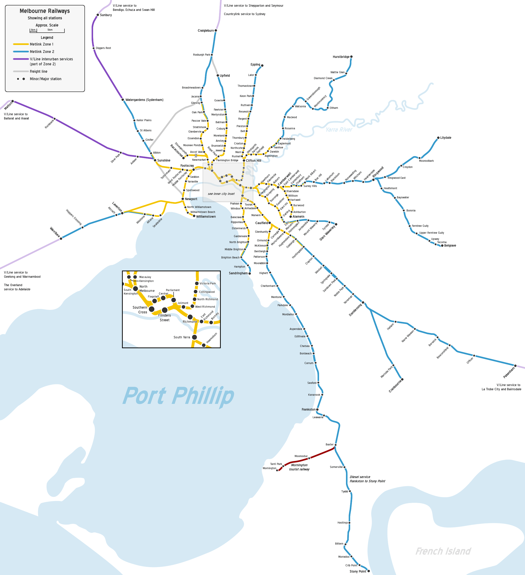
The Pakenham line branches from the Lilydale line at Richmond and shares four tracks with the Frankston line to Caulfield, running next to the Sandringham line as far as South Yarra.
From Caulfield the rest of the line is double track, with three platforms at Oakleigh, Dandenong and Westall. Although there are plans to add a third track on some sections between Caulfield and Dandenong as part of the Dandenong railway line triplication project.[1][2][3] Automatic block signalling is provided throughout.
Intermediate terminating facilities are provided at Caulfield, Oakleigh, Westall, Springvale, Dandenong, Narre Warren and Berwick. Stabling sidings for suburban trains are provided at Caulfield, Oakleigh, Westall, Dandenong, and Pakenham, although those at Caulfield and Oakleigh are not normally used. Westall is also the location of a suburban train maintenance workshop.
History
The Pakenham line began as part of the main line to Gippsland, but at the time the route through the suburbs has not been determined, so the first portion to open was the section between Oakleigh and Bunyip (Gippsland) in October 1877. Oakleigh was connected to the city at South Yarra in April 1879.
The section from South Yarra to Hawksburn was duplicated from opening, and duplication was extended to Caulfield in 1881, Oakleigh in 1883, and Dandenong in 1891.
In 1915 the line from South Yarra to Caulfield was quadrupled, and it was possibly at the same time that this section of the line was lowered into a cutting to eliminate numerous level crossings. Power signalling was provided between Richmond and Hawksburn at the same time, then on to Caulfield in 1921.
Electrification of the line to Dandenong occurred in two stages in 1922. Power signalling was extended to Carnegie in 1933 and Oakleigh in 1940.
In 1954 the line beyond Dandenong was electrified mainly because of the expected briquette traffic from the brown coal mines in the Latrobe Valley, and over the next two years most of the line between Dandenong and Pakenham was duplicated and provided with power signalling, although Narre Warren to Berwick was not done until 1962.
Oakleigh to Dandenong was converted to power signalling in stages from 1970 to 1972.
In 1975, suburban services were extended beyond Dandenong to Pakenham, which until then had only been served by the passenger trains connecting Gippsland to Melbourne.
In 2002, General Motors station closed and all trains ran express between Hallam and Dandenong.
On 1 March 2007, with the abolition of Zone 3, Pakenham was re-zoned to Zone 2 in the Melbourne Metropolitan rail system. This brought the cost of train fares down, improving accessibility to the public.
Services
- Pakenham, Officer, Beaconsfield, Berwick, Narre Warren, Hallam, Dandenong, all stations to Caulfield/Malvern, express to South Yarra, then all stations to Flinders Street via City Loop. During peak hour, these services commence from Berwick, Dandenong, Westall or Oakleigh.
- Pakenham, Officer, Beaconsfield, Berwick, Narre Warren, Hallam, Dandenong, Noble Park, Sandown Park, Springvale, Clayton, Oakleigh, Caulfield, South Yarra, then all stations to Flinders Street via City Loop. Peak only.
Line guide
Bold stations are termini, where some train services terminate; italic stations are staffed; and stations with an asterisk (*) are manned only during morning peak.
Branches from the City Loop at Flinders Street and Parliament.
Pakenham railway line Legend


1.2 km Southern Cross (SSS) Zone 1 

Flinders Street Viaduct 

0.0 km Flinders Street (FSS) Zone 1 

City Loop 2.4 km Richmond (RMD) Zone 1 
Burnley group 
City Link 
Yarra River 4.2 km South Yarra (SYR) Zone 1 
Sandringham line 
5.4 km Hawksburn (HKN) Zone 1 6.7 km Toorak (TOR) Zone 1 7.4 km Armadale (ARM)* Zone 1 8.9 km Malvern (MAL)* Zone 1 10.6 km Caulfield (CFD) Zone 1 Frankston line 12.3 km Carnegie (CNE)* Zone 1 13.2 km Murrumbeena (MRB)* Zone 1 

Outer Circle line 14.2 km Hughesdale (HUG) Zones 1 & 2 
Rosstown Railway 
15.4 km Oakleigh (OAK) Zones 1 & 2 17.0 km Huntingdale (HUN)* Zones 1 & 2 19.2 km Clayton (CLA) Zone 2 21.4 km Westall (WTL) Zone 2 23.3 km Springvale (SPG) Zone 2 
Springvale Cemetery Line 24.4 km Sandown Park (SNP) Zone 2 25.1 km Noble Park (NPK)* Zone 2 
Mile Creek 27.8 km Yarraman (YMN) Zone 2 
EastLink Yarraman Creek 30.0 km Dandenong (DNG) Zone 2 Dandenong Creek Cranbourne line Eumemmering Creek 
33.8 km General Motors (Closed) 
South Gippsland Freeway 36.2 km Hallam (HLM) Zone 2 Troups Creek 39.5 km Narre Warren (NWA) Zone 2 Princes Freeway 43.4 km Berwick (BEW) Zone 2 Cardinia Creek 45.8 km Beaconsfield (BFD) Zone 2 50.2 km Officer (OFC) Zone 2 Gum Scrub Creek 54.6 km Cardinia Road (Proposed) Toomuc Creek 56.9 km Pakenham (PKM) Zone 2 
Bairnsdale and Traralgon lines References
External links
- Timetables
- Official line map
- Network map
- Statistics and detailed schematic map at the VicSig enthusiast website
Railway Lines in Victoria Main lines
Bendigo Line · Mildura line · North East Line · (Melbourne-Sydney) · Orbost Line · Port Fairy Line · Portland line · Serviceton Line · South Gippsland Line · Tocumwal line · Western SG line (Melbourne-Adelaide)Branch linesAlexandra line · Alvie line · Balranald line · Bolangum line · Briagolong line · Bright line · Buninyong line · Carpolac line · Casterton line · Cobram line · Cohuna line · Coleraine line · Cudgewa line · Daylesford line · Deniliquin line · Forrest line · Grampians line · Heathcote line · Kulwin line · Lancefield line · Maffra line · Mansfield line · Mortlake line · Mirboo North line · Navarre line · Noojee line · Oaklands line · Outtrim line · Patchewollock line · Peechelba East line · Picola line · Portland line · Redesdale line · Red Hill line · Robinvale line · Skipton line · Strzelecki line · Stony Crossing line · Tatong line · Thorpdale line · Timboon line · Wahgunyah line · Waubra line · Wedderburn line · Wonthaggi line · Woodside line · Yackandandah line · Yanac line · Yaapeet line ·
Cross Country linesAvoca line · Geelong-Ballarat line · Eaglehawk–Inglewood line · Moolort Line · Toolamba–Echuca line
V/Line servicesGeelong Line · Warrnambool Line · Ballarat Line · Maryborough Line · Ararat Line · Bendigo Line · Swan Hill Line · Echuca Line · Seymour Line · Shepparton Line · Albury-Wodonga Line · Traralgon Line · Bairnsdale Line
Melbourne suburban servicesCity Loop · Werribee line · Williamstown line · Sydenham line · Craigieburn line · Flemington Racecourse line · Upfield line · Epping line · Hurstbridge line · Lilydale line · Belgrave line · Alamein line · Glen Waverley line · Pakenham line · Cranbourne line · Frankston line · Stony Point line (unelectrified) · Sandringham line
Inner Circle line · Outer Circle line · Rosstown Railway · St Kilda - Windsor line · Spring Vale Cemetery line · Mont Park line · Kew line · Red Hill line · Whittlesea line · Warburton line · Mornington line · Healesville line · St Kilda line · Port Melbourne line Tourist railwaysNarrow gauge branch linesWhitfield line · Gembrook line · Crowes line · Walhalla line
Melbourne goods linesNewport-Sunshine line · Albion-Jacana line · South Kensington-West Footscray line
Categories:- Railway lines in Melbourne
- Railway lines opened in 1877
- 5ft 3in gauge railways
Wikimedia Foundation. 2010.