- Cyclone Rona-Frank
-
Severe Tropical Cyclone Rona-Frank Category 3 cyclone (Australian scale) Category 2 tropical cyclone (SSHS) 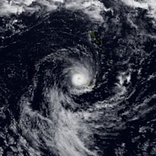
Image of Severe Tropical Cyclone Frank near landfall on New Caledonia. Formed February 10, 1999 Dissipated February 21, 1999 Highest winds 10-minute sustained:
150 km/h (90 mph)
1-minute sustained:
175 km/h (110 mph)Lowest pressure 955 mbar (hPa; 28.2 inHg) Fatalities 7 Damage $150 million (1999 USD) Areas affected Queensland, Australia and New Caledonia Part of the 1998–99 Australian region cyclone season
1998-99 South Pacific cyclone seasonSevere Tropical Cyclone Rona-Frank (JTWC designations 20P and 22P; RSMC Nadi designation 16F) was a damaging tropical cyclone that made landfall on Queensland, Australia on February 11, 1999, before dissipating and reforming to hit New Caledonia nine days later.
Forming during the second week of February, Rona rapidly intensified just before making landfall, causing $150 million (1999 USD; $198 million 2011 USD) in damage in Queensland. After crossing the Cape York Peninsula, the upper-level circulation was eventually tracked moving back onto the Coral Sea and reforming into another tropical cyclone, now named Frank. Frank rapidly intensified before making landfall on New Caledonia in the early morning of February 20. Despite being stronger at landfall in New Caledonia, Frank caused only minor damage there.
Due to the severity of damage in Queensland, the name "Rona" was retired and replaced with "Ruby" on the Australian region's list of tropical cyclone names.
Contents
Meteorological history
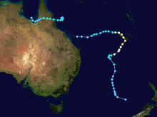 Storm path
During the second week of February 1999, a tropical low formed in the Coral Sea while embedded in a monsoon trough.[1] A middle- to upper-level trough over eastern Australia caused the tropical low to move slowly to the east. However, it began to weaken late on February 9 and had dissipated within 24 hours– causing the tropical low to slow down and become nearly stationary. The dissipation of the trough caused the upper levels of the tropical low to become favorable for development and as a result, the system rapidly intensified on February 10.[1][2]
Early on February 10, the Joint Typhoon Warning Center (JTWC) issued a Tropical Cyclone Formation Alert (TCFA) as the deep convection had increased in organization. In addition, it was noted that the upper-level outflow had improved as the system moved east-southeast at 7 km/h (4 mph).[3] Late that same day, the Tropical Cyclone Warning Center (TCWC) at Brisbane, Australia upgraded the tropical low into a category one tropical cyclone, naming it "Rona". At the time of the upgrade, the storm was 310 km (190 mi) east of the North Queensland coast.[1] Simultaneously, the JTWC upgraded Rona into a tropical storm, giving it the designation "20P".[3]
Early on February 11, TCWC Brisbane upgraded Rona to a category two tropical cyclone. Soon afterwards, a mid-level ridge south of the storm strengthened, causing Rona to rapidly accelerate to the west-northwest. At 1200 UTC, Rona reached its peak intensity as a category three severe tropical cyclone with winds of 130 km/h (80 mph).[4] Around this time, the maximum wind gust of 159 kilometres per hour (99 mph) was recorded, at Low Isles.[1] Severe Tropical Cyclone Rona made landfall near the mouth of the Daintree River at around 1300 UTC while still at peak intensity. Operationally, the JTWC assessed Rona to have made landfall with winds of 120 km/h (75 mph).[3] However, in their post-season analysis, this was lowered to 105 km/h (65 mph).[5] Five hours later, TCWC Brisbane downgraded Rona into a tropical low.[1] In addition, the JTWC issued their final advisory late on February 12 as Rona was predicted to move into the Gulf of Carpentaria and dissipate.[3] After February 12, the low-level circulation center of Rona became difficult to definitely identify, due to the formation of several smaller circulation centers. Despite this, the circulation at 850 hPa was still tracked as it curved back to the east to the Coral Sea.[1]
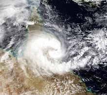 Severe Tropical Cyclone Rona approaching landfall on February 11.
Late on February 16, the JTWC issued a TCFA for the system which was about 555 km (345 mi) east-northeast of Rockhampton.[2][6] At the time, satellite imagery showed a well-defined lower-level circulation center with deep convection.[7] Two hours later, the JTWC issued their first warning on the system, designating it "22P".[7][8] During the evening of February 17, the Regional Specialized Meteorological Center (RSMC) at Nadi, Fiji began monitoring the system as a tropical depression with the designation "16F".[2][9]
During the afternoon of February 18, the JTWC upgraded Tropical Depression 22P into a tropical storm.[8] Late that night, RSMC Nadi reported that Tropical Depression 16F had moved east of 160°E and intensified into a category one tropical cyclone, and named it "Frank. At the time of the upgrade, the storm was centered 690 km (430 mi) west-northwest of Nouméa, New Caledonia.[6][9] By this time, an upper-level trough over eastern Australia moved into the Tasman Sea, improving the poleward outflow. This caused Frank to rapidly intensify over the next 24 hours.[6] Frank was assessed to have made landfall near the northern tip of New Caledonia at peak intensity with winds of 145 km/h (90 mph) at 0000 UTC on February 20.[9] Operationally, the JTWC had assessed the peak intensity at 185 km/h (115 mph),[7] however this was lowered to 175 km/h (110 mph) in post-season analysis.[8]
After making landfall on New Caledonia, Frank maintained peak intensity for 18 hours.[8][9] Soon afterwards, Frank entered an area of northwesterly wind shear and cooler sea surface temperatures, causing Frank to weaken rapidly. During the morning of February 21, RSMC Nadi passed warning responsibility to TCWC Wellington as the cyclone had moved south of 25°S.[10] 18 hours later, Frank merged with a trough to form an intense extratropical cyclone.[6] This extratropical cyclone eventually made landfall on the South Island of New Zealand near Westport with monitoring of the system ceasing on February 27.[9]
Impact and Retirement
Wettest tropical cyclones in Australia Precipitation Storm Location Rank (mm) (in) 1 1947 76.65 Peter 1979 Mt. Bellenden Ker[11] 2 1870 73.62 Rona-Frank 1999 Mt. Bellenden Ker[11] 3 1411 55.55 Mackay Cyclone 1918 Mackay 4 1318 51.89 Wanda 1974 Mt. Glorious[12] 5 927 36.50 April 1898 cyclone Whim Creek[13] 6 907 35.71 Feb. 1893 cyclone Crohamhurst[12] 7 900 35.43 Feb 1954 cyclone Springbrook[12] 8 759 29.88 Grace 2004 Topaz[14] 9 747 29.40 Neville 1992 Garden Point[15] 10 732 28.81 Carlos 2011 Darwin[16] During its Queensland landfall, Cyclone Rona caused a 1 metre (3.3 ft) storm surge in Port Douglas. Also, at the mouth of the Mossman River, a 1.4 metres (4.6 ft) storm surge was noted. The highest rains associated with Rona, 1,870 millimetres (73.6 in), were measured at Bellenden Ker in Northern Queensland.[11] On February 12, a state of disaster was declared for Cairns and Innisfail due to the severity of damage caused by the storm.[17]
Strong winds and flooding caused significant crop and infrastructure damage from Cape Kimberly to Cape Tribulation. [6][18] In the Cow Bay area, two houses were destroyed, twelve others were damaged, and a car was crushed by a falling tree.[2] Seven deaths were attributed to the storm in Queensland.[19] Eventually, the damage estimates from Cyclone Rona totaled $150 million (1999 USD; $198 million 2011 USD) in Queensland.[20]
Despite passing only 27 km (17 mi) west of Nouméa, the overall damage in New Caledonia was minimal. Some of the townships in the northern and western sides of the island experienced power outages and disruptions to the water supply and communication with landslides on some coastal roads. In addition crop damage was found in the northeastern side of the island. Despite this, there were no reports of severe damage to infrastructure or any casualties.[2] Offshore, three men were found 545 km (339 mi) southwest of Nouméa after their yacht sank three days previously on February 21.[21]
Due to the damage from Cyclone Rona, the name "Rona" was retired and was replaced with "Ruby". However, due to the minimal damage in New Caledonia, the name "Frank" was not retired and remains on the South Pacific naming lists.[22]
See also
- 1998–99 Australian region cyclone season
- 1998-99 South Pacific cyclone season
References
- ^ a b c d e f "Severe Tropical Cyclone Rona". Bureau of Meteorology (Australia). http://www.bom.gov.au/cyclone/history/rona.shtml. Retrieved 17 January 2011.
- ^ a b c d e Padgett, Gary (1999). "Monthly Tropical Cyclone Summary: February 1999". Australian Severe Weather. http://www.typhoon2000.ph/feb99.txt. Retrieved 17 January 2011.
- ^ a b c d "Tropical Cyclone Rona: JTWC Advisories". Joint Typhoon Warning Center. Australian Severe Weather. 1999. http://www.australiasevereweather.com/tropical_cyclones/1998_1999/warnings/tropical_cyclone_rona_jtwc_advisories.htm. Retrieved 17 January 2011.
- ^ "BoM Best Track Data for Severe Tropical Cyclone Rona". Bureau of Meteorology (Australia). http://www.webcitation.org/5voRCtSdQ. Retrieved 17 January 2011.
- ^ "JTWC Best Track Data for Tropical Cyclone 20P (Rona)". Joint Typhoon Warning Center. http://www.usno.navy.mil/NOOC/nmfc-ph/RSS/jtwc/best_tracks/1999/1999s-bsh/bsh201999.txt. Retrieved 17 January 2011.
- ^ a b c d e Oates, Sue (June 2000). "The South Pacific and Southeast Indian Ocean Tropical Cyclone Season 1998-99". Australian Meteorological Magazine 49: 223–244.
- ^ a b c "Tropical Cyclone Frank: JTWC Advisories". Joint Typhoon Warning Center. Australian Severe Weathre. 1999. http://www.australiasevereweather.com/tropical_cyclones/1998_1999/warnings/tropical_cyclone_frank_jtwc_advisories.htm. Retrieved 17 January 2011.
- ^ a b c d "JTWC Best Track Data for Tropical Cyclone 22P (Frank)". Joint Typhoon Warning Center. http://www.usno.navy.mil/NOOC/nmfc-ph/RSS/jtwc/best_tracks/1999/1999s-bsh/bsh221999.txt. Retrieved 17 January 2011.
- ^ a b c d e "South Pacific Ocean Best Track Data 1967–2006" (xls). Fiji Meteorological Service, Meteorological Service of New Zealand Limited, Bureau of Meteorology (Australia). National Oceanic and Atmospheric Administration. 2009-05-22. ftp://eclipse.ncdc.noaa.gov/pub/ibtracs/original-bt-data-files/wellington/TC_BT_1967_2006.xls. Retrieved 2011-01-17.
- ^ "Tropical Cyclone Seasonal Summary 1998-99". RSMC Nadi. http://www.met.gov.fj/documents/TC_Seasonal_Summary_98-991188357223.pdf. Retrieved 19 January 2011.
- ^ a b c "Climate Education: Flood". Australian Bureau of Meteorology. 2010. http://www.bom.gov.au/lam/climate/levelthree/c20thc/flood.htm. Retrieved January 18, 2011.
- ^ a b c Bureau of Meteorology. Tropical Cyclones in Queensland. Retrieved on 2008-01-02.
- ^ Bureau of Meteorology. Tropical Cyclones in Western Australia. Retrieved on 2008-01-02.
- ^ Gary Padgett. Monthly Global Tropical Cyclone Summary: March, 2004. Retrieved on 2006-10-11.
- ^ "Tropical Cyclone Neville". Bureau of Meteorology. 2011. http://www.bom.gov.au/cyclone/nt/Neville.shtml. Retrieved 2011-02-15.
- ^ Dillon, Meagan (18 February 2011). "Wet season almost the wettest wet yet". Northern Territory News. News Limited. Archived from the original on 18 February 2011. http://www.webcitation.org/5wZLEIC6y. Retrieved 18 February 2011.
- ^ Staff Writer (1999-02-12). "Qld Cyclone Rona disaster". Associated Press. http://www.highbeam.com/doc/1P1-21441306.html. Retrieved 2009-07-30.
- ^ Padgett, Gary. "Monthly Global Tropical Cyclone Summary for March 1999". http://www.typhoon2000.ph/mar99.txt. Retrieved 2009-07-29.
- ^ "Cyclones - Rona (damage from storm)". European Space Agency. February 1999. http://earth.esa.int/ew/cyclones/rona_99/. Retrieved 2009-07-29.
- ^ "CYCLONES TO HAVE IMPACTED ON QUEENSLAND, AUSTRALIA FROM 1864". Windworker.com.au. http://www.windworker.com.au/qldcyclones.htm. Retrieved 2009-07-29.
- ^ "Orion helps rescue trio in liferaft - National - NZ Herald News". The New Zealand Herald. 1999-02-23. http://www.nzherald.co.nz/nz/news/article.cfm?c_id=1&objectid=2936. Retrieved 18 January 2011.
- ^ "Tropical Cyclone Operational Plan — 2006". World Meteorological Organization. http://www.wmo.ch/pages/prog/www/tcp/documents/TCP-24OP-PLN2006edition-english.pdf. Retrieved 2009-07-29.
List of retired Australian cyclone names 1960s 1970s 1980s 1990s 2000s 2010s Categories:- Retired Australian region cyclones
- Cyclones in Australia
- Category 3 Australian region cyclones
- 1998–99 South Pacific cyclone season


Wikimedia Foundation. 2010.