- Cyclone Olivia
-
Severe Tropical Cyclone Olivia Category 4 cyclone (Australian scale) Category 4 Tropical cyclone (SSHS) 
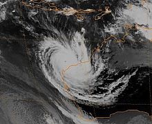
Severe Tropical Cyclone Olivia near peak intensity off the coast of Western Australia Formed 3 April 1996 Dissipated 12 April 1996 Highest winds 10-minute sustained:
195 km/h (120 mph)
1-minute sustained:
230 km/h (145 mph)Lowest pressure 925 mbar (hPa; 27.32 inHg) Fatalities 10 injuries Damage $2 million (1996 USD) Areas affected Northern Territory and Western Australia Part of the 1995–96 Southern Hemisphere tropical cyclone season Severe Tropical Cyclone Olivia was a powerful Category 4 cyclone that produced the highest non-tornadic winds on record, 408 km/h (253 mph).
Contents
Meteorological history
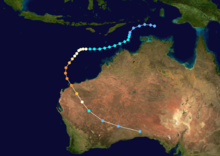
Severe Tropical Cyclone Olivia was first identified by the Bureau of Meteorology as a low to mid-level area of low pressure over Indonesia north of Darwin, Australia on 2 April. The system slowly became better organized despite strong wind shear as it sharply turned south.[1] Early on 5 April, the Joint Typhoon Warning Center (JTWC) classified the system as Tropical Depression 25S as it resumed its westward track.[2] Shortly thereafter, the Bureau of Meteorology upgraded the system to a Category 1 cyclone, designating the storm as Tropical Cyclone Olivia.[1][3] The westward turn occurred in response to a mid-level ridge to the south of Olivia strengthened.[1] Shortly after being upgraded by the Bureau of Meteorology, the JTWC followed suit and classified the system as a tropical storm.[2]
Over the following several days, persistent wind shear prevented convection from developing around the center of circulation. However, by 8 April, an upper-level trough passed to the south of the developing cyclone, leading to lower shear.[1] Following this, the system had developed sufficiently for the JTWC to upgrade it to a Category 1 equivalent on the Saffir–Simpson Hurricane Scale (SSHS), with winds estimated at 120 km/h (75 mph 1-minute sustained) around the center of the storm.[2] Around the same time, the Bureau of Meteorology upgraded Olivia to a severe tropical cyclone, having similar wind speeds.[1][3] After reaching this intensity, the mid-level ridge south of the cyclone began to weaken, leading to Olivia turning towards the southwest. By 9 April, the system attained Category 4 intensity as it continued to strengthen.[1]
During the afternoon of 9 April, Olivia attained its lowest barometric pressure of 925 hPa (mbar) and sustained winds were estimated at 195 km/h (120 mph 10-minute sustained) by the Bureau of Meteorology.[1][3] Several hours later, the JTWC assessed the cyclone to have attained Category 4 status on the SSHS with winds of 230 km/h (145 mph 1-minute sustained).[2] By this time, another trough bypassed the cyclone, this time causing Olivia to turn southward before rapidly tracking southeast. Early on 10 April, data from a nearby weather radar at the Learmonth Airport near Exmouth, Western Australia, showed that the storm had developed a 65 km (40 mi) wide eye.[1]
Late on 10 April, the center of Olivia passed near Barrow Island at peak intensity. Shortly thereafter, the storm passed near Varanus Island as a high-end Category 4 or low-end Category 5 cyclone.[3][4] Within several hours of passing by Varanus Island, Olivia made landfall near Mardie at peak intensity.[1] Shortly thereafter, the storm began to weaken overland. Accelerating to the southeast, the storm became disorganized and winds decreased below hurricane-force.[3] During the afternoon of 11 April, Olivia weakened to a tropical low over southern Australia before moving over the Great Australian Bight and losing its identity as a gale-force low.[1]
Impact and records
As a minimal cyclone in the Timor Sea, Olivia brought minor rainfall and gusty winds to parts of the Northern Territory. Over land, no damage was reported despite a 2 m (6.6 ft) storm surge in localized areas. An oil rig in the Timor Sea recorded a wind gust of 127 km/h (79 mph) during the storm's passage.[5]
Offshore, Cyclone Olivia produced large swells up to 21 m (69 ft). These waves, in combination with record breaking winds exceeding 265 km/h (165 mph), caused several million dollars in losses to oil platforms.[1] On Barrow Island, a world-record wind gust of 408 km/h (253 mph) was recorded at the local airport. Initially, this gust was subject to confirmation and not released to the public. It was not until 26 January 2010 that the World Meteorological Organization announced the confirmation of this wind gust. This gust surpassed the previous non-tornadic wind speed of 374 km/h (232 mph) on Mount Washington in the United States in April, 1934.[6]
See also
- 1995–96 Southern Hemisphere tropical cyclone season
- 1999 Oklahoma tornado outbreak – produced an F5 tornado which had winds estimated at 511 km/h (318 mph) by the doppler data of the weather radar
- Mount Washington – location of the previous highest non-tornadic winds, 374 km/h (232 mph)
- Hurricane Gustav – thought to have produced the highest wind gust in a tropical cyclone at 340 km/h (211 mph)
References
- ^ a b c d e f g h i j k Jeff Callaghan (August 1997). "The South Pacific and southeast Indian Ocean tropical cyclone season 1995-96" (PDF). Australian Bureau of Meteorology. http://www.bom.gov.au/amm/docs/1997/callaghan.pdf. Retrieved 27 January 2010.
- ^ a b c d Joint Typhoon Warning Center (1997). "Cyclone 25S Best Track". United States Navy. http://www.usno.navy.mil/NOOC/nmfc-ph/RSS/jtwc/best_tracks/1996/1996s-bsh/bsh251996.txt. Retrieved 27 January 2010.
- ^ a b c d e "Australian Region Tropical Cyclone Best Tracks". Australian Bureau of Meteorology. 2009. http://www.bom.gov.au/cgi-bin/silo/cyclones.cgi. Retrieved 27 January 2010.
- ^ "Tropical Cyclones in Western Australia - Extremes". Australian Bureau of Meteorology. 2010. http://www.bom.gov.au/weather/wa/cyclone/about/extremes.shtml. Retrieved 27 January 2010.
- ^ "Northern Territory Cyclones: Tropical Cyclone Olivia". Australian Bureau of Meteorology. 1997. http://www.bom.gov.au/weather/cyclone/nt/Olivia.shtml. Retrieved March 15, 2010.
- ^ "Highest surface wind speed - Tropical Cyclone Olivia sets world record". World Record Academy. 26 January 2010. http://www.worldrecordsacademy.org/weather/highest_surface_wind_speed_Tropical_Cyclone_Olivia_sets_world_record_101519.htm. Retrieved 28 January 2010.
External links
- Joint Typhoon Warning Center (JTWC).
- Australian Bureau of Meteorology (TCWC's Perth, Darwin & Brisbane).
List of retired Australian cyclone names 1960s 1970s 1980s 1990s 2000s 2010s Categories:- Retired Australian region cyclones
- 1996 in Australia
- 1995–96 Australian region cyclone season
- Category 4 Australian region cyclones
Wikimedia Foundation. 2010.

