- 1999–00 Australian region cyclone season
Infobox hurricane season
Basin=Aus
Year=2000
Track=1999-2000 Australian cyclone season summary.jpg
First storm formed=December 9 ,1999
Last storm dissipated=April 22 ,2000
Strongest storm name=John
Strongest storm pressure=915
Strongest storm winds=110
Average wind speed=10
Total depressions=
Total storms=12
Total hurricanes=5
Total intense=
Fatalities=0
Da
Inflated=
five seasons=1997–98, 1998–99, 1999–00, 2000–01, 2001–02 The 1999-00 Australian region cyclone season was an event in the annual cycle oftropical cyclone formation and ran fromNovember 1 ,1999 toApril 30 ,2000 . The regional tropical cyclone operational plan also defines a "tropical cyclone year" separately from a "tropical cyclone season", with the "tropical cyclone year" for this season lasting fromJuly 1 ,1999 toJune 30 ,2000 .Two of the most notable cyclones of the season were Steve and Rosita.
Cyclone Steve transversed the entireAustralia n continent, and although a fairly weak cyclone, caused widespread flooding inQueensland ,Northern Territory andWestern Australia , whileCyclone Rosita made an almost direct hit on Broome as a severe Category 5 cyclone, devastating several remote stations and the town itself. Rosita surprised many residents of its arrival, as it made landfall very late in the season.__TOC__torms
The scope of this section is limited to tropical cyclones that existed in the Southern Hemisphere between longitudes 90°E and 160°E during the 1999-2000 season. Furthermore, storms are listed below in chronological order of naming. There are four warning centres in this region, each responsible for naming and warning for a small portion of the region, but this section does not list the storms by the area they formed in.
Tropical Cyclone Ilsa
Infobox Hurricane Small
Basin=Aus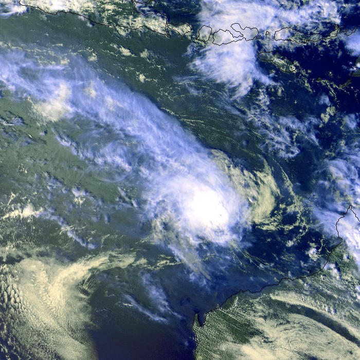
Track=Ilsa 1999 track.pngDecember 10
Dissipated=December 17
10-min winds=55
1-min winds=60
Pressure=980Cocos Islands on theDecember 11 ,1999 . The cyclone moved to the south of Christmas Island on the 13th producing a heavy swell which caused some damage. Its development was impeded by verticalwindshear for a large part of its lifetime. After a long track eastwards across theIndian Ocean it eventually crossed theWestern Australian coastline on the Eighty Mile Beach near the Sandfire Roadhouse during the early afternoon ofDecember 17 ,1999 . Apart from producing heavy rainfall, Ilsa did not produce any significant damage.cite web|author=Bureau of Meteorology|title=BoM - WA Tropical Cyclone Season Summary 1999-00|publisher=Bureau of Meteorology|accessdate=August 7|accessyear=2006|url=http://www.bom.gov.au/weather/wa/cyclone/about/seasonsummary199900.shtml]evere Tropical Cyclone John
Infobox Hurricane Small
Basin=Aus
Track=John 1999 track.pngDecember 10
Dissipated=December 15
10-min winds=110
1-min winds=130
Pressure=915Timor on9 December 1999 . It rapidly intensified and moved towards thePilbara coast ofWestern Australia . Just before landfall it was a severe category 5 storm with a central pressure of 915 hPa, with winds estimated at being up to 290 km/h (180 mph). The cyclone crossed the coast just to the west of Whim Creek between Port Hedland and Karratha on 8:30 am (WST)December 15 ,1999 . At the time of coastal crossing, it was estimated to have a central pressure between 930 and 940 hPa. The cyclone moved inland before dissipating the next day.Port Hedland experienced gale force winds for a period of 18 hours and near storm force winds with gusts to 124 km/h (78 mph) were observed on
December 15 for most of the day. A maximum storm surge of 2 metres was recorded by the Port Hedland Authority at 6am WST. At Karratha, on the western side of the circulation, the maximum wind gust recorded was 113 km/h (70 mph). At Cape Lambert, winds averaged 150 km/h (95 mph) for 5 hours with a maximum gust of 210 km/h (130 mph).There was some minor damage in Karratha. High winds and flooding caused extensive structural damage at many stations in the Pilbara and mining operations were suspended at many sites. The 113-year old Whim Creek Hotel suffered major damage with the top floor lost, and the town of Newman experienced some flooding (500 mm (20 in) of rain was recorded). However, major towns in the Pilbara escaped any serious damage, and the damage was relatively light due to the sparseness of population in the area John hit. There were no deaths from John.cite web|author=Gary Padgett|title=MONTHLY GLOBAL TROPICAL CYCLONE SUMMARY - DECEMBER, 1999|accessdate=August 7|accessyear=2006|url=http://www.australiansevereweather.com/cyclones/2000/summ9912.htm]
Ten hours prior to landfall on the Australian coastline, John was moving southwards directly towards Karratha and Dampier. Had John failed to turn to the south-east like what it did, damage to the towns of Karratha, Dampier, Roebourne and Wickham caused by John would have been much worse.cite web|author=Bureau of Meteorology|title=Report on John, Steve and Rosita|accessdate=August 7|accessyear=2006|url=http://www.bom.gov.au/weather/wa/cyclone/about/roebourne/john_steve_rosita.pdf]
Tropical Cyclone Kirrily
Infobox Hurricane Small
Basin=Aus
Track=Kirrily 2000 track.pngJanuary 24
Dissipated=February 1
10-min winds=60
1-min winds=85
Pressure=975Cocos Islands onJanuary 24 ,2000 and moved west southwest towards theWestern Australian coast. Kirrily intensified, reachingCategory 2 status onJanuary 27 . OnJanuary 28 , Kirrily turned southwest, moving away from the coast, weakening to below cyclone strength byJanuary 31 , while located approximately 900 km (560 mi) west of Carnarvon. The lowest central pressure was estimated to have reached 970 hPa.evere Tropical Cyclone Leon-Eline
Infobox Hurricane Small
Basin=Aus
Track=Leon-Eline 2000 track.pngFebruary 1
Dissipated=February 8
10-min winds=75
1-min winds=75
Pressure=960Christmas Island on the3rd February was named Leon on the4th February . Following a general southwesterly track during the 5th and 6th, the system developed into a severe tropical cyclone with an estimated central pressure of 960 hPa. By the 8th, Tropical Cyclone Leon passed to the south of theCocos (Keeling) Islands .cite web|author=Bureau of Meteorology|title=SIGNIFICANT WEATHER - FEBRUARY 2000|publisher=Bureau of Meteorology|accessdate=August 7|accessyear=2006|url=http://www.bom.gov.au/inside/services_policy/public/sigwxsum/sigw0200.shtml] Leon was re-named Leon-Eline once it moved outside Perth's area of responsibility; for more information on Leon-Eline, see1999-00 South-West Indian Ocean tropical cyclone season .Tropical Cyclone Marcia
Infobox Hurricane Small
Basin=Aus
Formed=February 14
Dissipated=February 18
10-min winds=35
Pressure=995Marcia was a Category 1 cyclone that formed onFebruary 15 , and remained quasi-stationary in the open Indian Ocean at around 15˚S, 103˚E. Perth issued its final warning onFebruary 17 at 0400 UTC, downgrading to a tropical low. Marcia dissipated onFebruary 21 . The lowest central pressure was 992 hPa achieved onFebruary 16 at 1000 UTC.cite web|author=Gary Padgett|title=CYCLONE TRACKS, FEBRUARY, 2000|accessdate=August 7|accessyear=2006|url=http://www.australiansevereweather.com/cyclones/2000/trak0002.htm]Tropical Cyclone Steve
Infobox Hurricane Small
Basin=Aus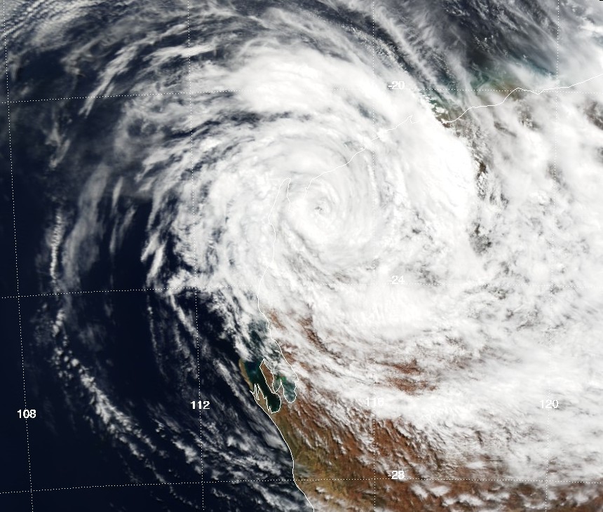
Track=Steve 2000 track.pngFebruary 27
Dissipated=March 11
10-min winds=60
1-min winds=65
Pressure=975February 25 ,2000 and crossed theQueensland coast north of Cairns the same day as a strong Category 2 in the Australian Scale. It weakened to a low and then redeveloped in theGulf of Carpentaria . Steve then crossed into theNorthern Territory and weakened again. The low then moved over theIndian Ocean near Broome and reformed again into a tropical cyclone. It intensified into a strong Category 2, reaching its peak intensity, and made landfall to the west of Karratha. It weakened to a Category 1 and emerged again over theIndian Ocean near Carnarvon. It finally made its fourth landfall as a weak Category 1 onMarch 9 ,2000 nearShark Bay . It accelerated to the south-east towards Esperance and emerged over theGreat Australian Bight where it became extratropical.cite web|author=Bureau of Meteorology|title=Bureau - Tropical Cyclone Steve|publisher=Bureau of Meteorology|accessdate=June 16|accessyear=2006|url=http://www.bom.gov.au/info/cyclone/steve/index.shtml]There was extensive damage across a wide area of Australia, from Cairns in
Queensland to Esperance inWestern Australia on11 March . Most of the damage was caused by severe flooding which resulted with costs in excess of $100 million (AUD). There were no reports of deaths from Cyclone Steve.cite web|author=Bureau of Meteorology|title=BoM-Impact from Steve|publisher=Bureau of Meteorology|accessdate=June 16|accessyear=2006|url=http://www.bom.gov.au/info/cyclone/steve/steve_impacts.shtml]evere Tropical Cyclone Norman
Infobox Hurricane Small
Basin=Aus
Track=Norman Indian 2000 track.pngFebruary 29
Dissipated=March 9
10-min winds=100
1-min winds=120
Pressure=93029 February ,2000 . The cyclone tracked parallel to thePilbara coastline for 3 days at a distance of about 250 km (155 mi), before continuing on a westward track away from theWestern Australian coast. Norman quickly reached a peak intensity as acategory 5 cyclone on 2 March with a central pressure estimated at 920 hPa, while about 780 km (485 mi) to the west-northwest of Exmouth. Norman soon weakened over the following 2 days. During6 March , the cyclone changed direction to a southerly track. The system finally dissipated on8 March . Norman had no direct impact on Western Australia.Tropical Cyclone Olga
Infobox Hurricane Small
Basin=Aus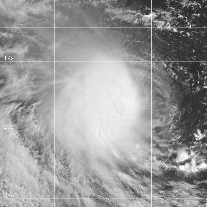
Track=Olga 2000 track.pngMarch 16
Dissipated=March 20
10-min winds=50
1-min winds=50
Pressure=985Timor Sea on15 March ,2000 . The low maintained a west southwest track, paralleling the Kimberley and Pilbara coasts. The low was named Tropical Cyclone Olga on17 March while located approximately 570 km (355 mi) to the north of Exmouth. Olga intensified tocategory 2 status with a central pressure of 980 hPa. By the 20th the system had weakened to a tropical low while located about 970 km (605 mi) to the west of Carnarvon. The system had no direct effect on Western Australia.Tropical Cyclone Tessi
Infobox Hurricane Small
Basin=Aus
Track=Tessi 2000 track.pngApril 1
Dissipated=April 2
10-min winds=60
1-min winds=50
Pressure=9802 April and crossed the coast near Bambaroo and Crystal Creek (80 km (50 mi) north of Townsville) early on3 April as a Category 2 system on landfall.Tessi's winds unroofed buildings, uprooted trees, downed power lines in the area between Ingham and Ayr. The Strand suffered wave damage with several boats destroyed. Heavy rain caused landslides on Townsville's Castle Hill destroying two homes and requiring the evacuation of another fifty homes. Considerable damage to personal property and to Townsville City infrastructure was reported. Townsville Aero reported a record April wind gust of 130 km/h (81 mph), a record April daily rainfall total of 271.6 mm (10.7 in) and the cyclone was the main contribution to a record April monthly total of 546.2 mm (21.5 in). In addition, moderate damage was also reported throughout
Magnetic Island and the then Thuringowa.Minor to moderate flooding in the Haughton River increased to major in the lower reaches with the highest level since the start of records in 1978 being recorded at
Giru .cite web|author=Bureau of Meteorology|title=SIGNIFICANT WEATHER - APRIL 2000|publisher=Bureau of Meteorology|accessdate=July 7|accessyear=2006|url=http://www.bom.gov.au/inside/services_policy/public/sigwxsum/sigw0400.shtml]Tropical Cyclone Vaughan
Infobox Hurricane Small
Basin=Aus
Track=Vaughan 2000 track.pngApril 3
Dissipated=April 6
10-min winds=60
1-min winds=50
Pressure=977New Caledonia on the29 March . The low tracked northwest through theCoral Sea to become Tropical Cyclone Vaughan early on4 April . The system rapidly intensified to Category 2 during the morning of the 4th and tracked westward toward the northQueensland tropical coast. Cyclone Vaughan weakened a little during5 April and was downgraded to a Category 1 system before re-intensifying to Category 2 early on the6 April . However by late morning on the 6th the system again rapidly weakened and was downgraded below cyclone strength during the afternoon. The remnants of Cyclone Vaughan drifted slowly northwest and dissipated during7 April . There was no evidence of any significant impact on the coast from Vaughan.evere Tropical Cyclone Paul
Infobox Hurricane Small
Basin=Aus
Track=Paul Indian 2000 track.pngApril 11
Dissipated=April 20
10-min winds=110
1-min winds=130
Pressure=91513 April ,2000 and moved west, away from the West Australian coastline, thus never posing any threat to coastal communities. The cyclone showed rapid intensification and Severe Tropical Cyclone Paul reached Category 5 status during15 April , and the lowest central pressure was estimated to be have been about 920 hPa the following day. Severe Tropical Cyclone Paul passed about 200 km (125 mi) to the south of theCocos (Keeling) Islands during the 17th and the central pressure was estimated to be about 940 hPa. Wind gusts at Cocos Islands were in the order of around 50 km/h (30 mph). TC Paul continued to weaken as the system followed a general west-south-west track across theIndian Ocean . The cyclone slowed to be almost stationary on20 April and weakened to below cyclone strength. Perth issued the final warning for TC Paul on the20th April when the Category 1 cyclone was in the vicinity oflatitude 14.7° south andlongitude 94.3° east.evere Tropical Cyclone Rosita
Infobox Hurricane Small
Basin=Aus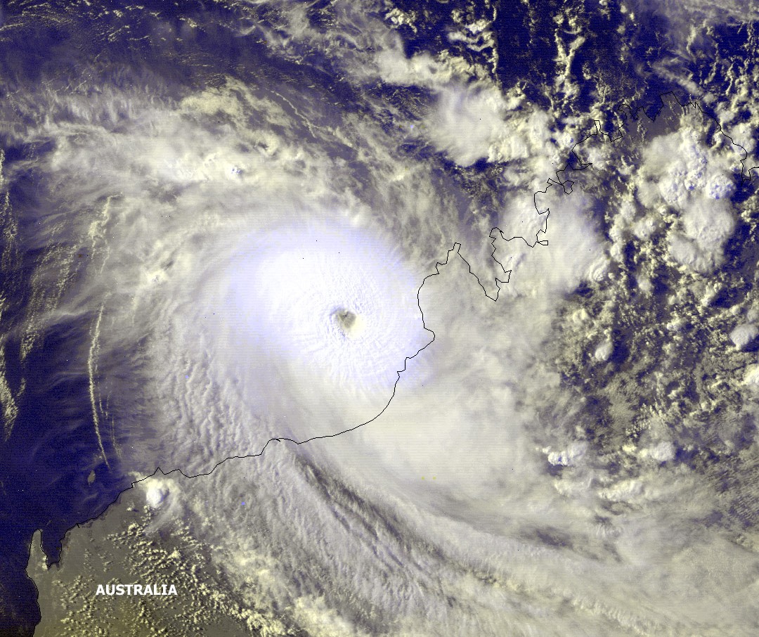
Track=Rosita 2000 track.pngApril 15
Dissipated=April 20
10-min winds=100
1-min winds=125
Pressure=930April 17 while located 670 km (415 mi) north of Port Hedland. It rapidly intensified into a Category 5 storm on19 April while moving to the east south-east. Rosita struck the Kimberley coast as a Category 4 at 0100 hours WST on20 April ,2000 , 40 km (25 mi) south of Broome. Its lowest central pressure was estimated to be 930 hPa a couple of hours prior to landfall. The small cyclone left severe structural damage in Eco Beach tourist resort, Yardoogarra and Thangoo Stations. Elsewhere there was considerable tree and powerline damage.torm names
Most tropical cyclones in the region are assigned names by the Australian Bureau of Meteorology. Tropical cyclones are named if they are non-frontal low pressure systems of synoptic scale developing over warm waters, or if Dvorak intensity analysis indicate the presence of gale force or stronger winds near the centre. Therefore, tropical systems with gales in one or more quadrants, but not near the centre, are not named.cite web|title=Tropical Cyclones: Frequently Asked Questions|accessdate=2008-08-15|publisher=Australian Government Bureau of Meteorology|url=http://www.bom.gov.au/weather/cyclone/faq/index.shtml] All names assigned in the Australian region are selected sequentially. Only the names used during this cyclone season are listed below. The complete list of names for each basin are found in the
World Meteorological Organization 's official lists.cite web|year=1999|title=Tropical Cyclone Operational Plan for the South Pacific and South-East Indian Ocean|accessdate=2008-08-15|publisher=World Meteorological Organization|url=http://www.wmo.ch/pages/prog/www/Peng/tcp/documents/doc/Op-pln99.doc]Each Australian
Tropical Cyclone Warning Centre (Perth, Darwin, andBrisbane ) maintains a list of names arranged alphabetically and alternating male and female. Tropical cyclones that develop in the South-East Indian Ocean are assigned names by the Tropical Cyclone Warning Centre in Perth. This region includes the areas east of 90°E, south of theEquator , and west of 125°E. Tropical cyclones that develop south of the Equator between 125°E and 141°E are assigned names by the Tropical Cyclone Warning Centre in Darwin,Northern Territory . This area includes most of the cyclones that form in theArafura Sea and WesternGulf of Carpentaria . Tropical cyclones in theCoral Sea and Eastern Gulf of Carpentaria between 141°E and 160°E and south of 10°S are assigned names by the Tropical Cyclone Warning Centre in Brisbane,Queensland .Perth
* Ilsa - John - Kirrily - Leon - Marcia - Norman - Olga - Paul - RositaBrisbane
* Steve - Tessi - VaughanNo storms formed in Darwin region during the 1999-2000 season. However,
Cyclone Steve was named by TCWC Brisbane before passing through the warning area of Darwin. Additionally, the Tropical Cyclone Warning Centre inPort Moresby ,Papua New Guinea reserves the right to name cyclones that develop in theSolomon Sea andGulf of Papua , north of 10°S between 141°E and 160°E. Names are selected randomly from their list and retired once they are used.cite web|year=2006|title=Tropical Cyclone Operational Plan for the South Pacific and South-East Indian Ocean|accessdate=2008-08-15|publisher=World Meteorological Organization|url=http://www.wmo.int/pages/prog/www/tcp/documents/TCP-24-OP-PLN-2006-edition-english.pdf] No cyclones were named by this warning centre during the 1999-00 season.ee also
*
List of Southern Hemisphere cyclone seasons
* Atlantic hurricane seasons: 1999, 2000
* Pacific hurricane seasons: 1999, 2000
* Pacific typhoon seasons: 1999, 2000
* North Indian Ocean cyclone seasons: 1999, 2000References
External links
* [https://metocph.nmci.navy.mil/jtwc.html Joint Typhoon Warning Center (JTWC)]
* [http://www.met.gov.fj/index.php Fiji Meteorological Service (RSMC Nadi)]
* [http://www.wmo.int/index-en.html World Meteorological Organization]
* [http://ftp.wmo.int/pages/prog/www/TCP_vO/Reports/RA%20V%20TCC-VIII%20FINAL%20REPORT.pdf RA V Tropical Cyclone Committee Final Report]
* [http://www.wmo.ch/pages/prog/www/Peng/TCP_vO/TDs/TD1082-TCseason2000.pdf WMO Annual Summary of Global Tropical Cyclone Seasons 2000]
* [http://metocph.nmci.navy.mil/jtwc/atcr/2000atcr/pdf.html Joint Typhoon Warning Center 2000 ATCR]
* [ftp://ftp.bom.gov.au/anon2/home/ncc/cyclone/cyclones_newformat.zip Raw cyclone track data]
* [http://www.bom.gov.au/inside/services_policy/public/sigwxsum/sigwmenu.shtml BoM Monthly Significant Weather Summaries]
* [http://www.bom.gov.au/inside/eiab/reports/html/appendix7.shtml BoM 1999-2000 Annual Weather Report]
* [http://www.bom.gov.au/weather/wa/cyclone/about/seasonsummary199900.shtml 1999-00 Annual Summary (Western Australia)]
* [http://australiasevereweather.com/cyclones/tropical_cyclones_2000_summaries_and_track_data.htm July 1999 to June 2000 Tropical Cyclone Summaries and Operational Track Data]
* [http://australiasevereweather.com/cyclones/2000/summ1999-2000.htm Gary Padgett's Southern Hemisphere 1999-2000 Tropical Cyclone Season Review]
Wikimedia Foundation. 2010.