- Nadi, Fiji
-
"Nadi" redirects here. For other uses, see Nadi (disambiguation).
Nadi Nadi Nadi within Fiji Coordinates: 17°48′00″S 177°25′00″E / 17.8°S 177.4166667°ECoordinates: 17°48′00″S 177°25′00″E / 17.8°S 177.4166667°E Country  Fiji
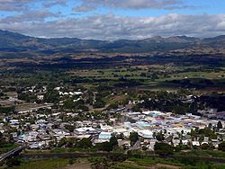
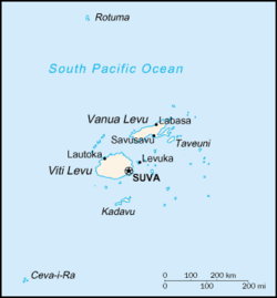
FijiIsland Viti Levu Division Western Division Population (2011) - Total 42,284 Nadi (pronounced [ˈnandi]) is the third-largest conurbation in Fiji. It is located on the western side of the main island of Viti Levu, and had a population of 42,284 at the most recent census, in 2007. Nadi is multiracial with many of its inhabitants Indian or Fijian, along with a large transient population of foreign tourists. Along with sugar cane production, tourism is a mainstay of the local economy. The Nadi region has a higher concentration of hotels and motels than any other part of Fiji.[citation needed]
With its large Indo-Fijian population, Nadi is a centre for Hinduism and Islam in Fiji. The downtown area is defined by the Nadi River and Viseisei village on the west side, and the beautfiul Sri Siva Subramaniya temple on the east. It is the largest Hindu temple in the Southern hemisphere, and is a site for pilgrims. Nadi International Airport located 9 kilometers from the city, is the largest airport in Fiji and is served by Air Pacific (the international airline of Fiji), Air Calin, Air Niugini, Air New Zealand, Jetstar.Pacific Blue, V Australia, Korean Air, Continental Micronesia, and some other domestic airlines such as Pacific Sun, Air Fiji and V.I.P charter airline Air Wakaya. Thus, Nadi is the principal port of entry for air travelers to Fiji, even though it is on the opposite (western) side of the island of Viti Levu from the nation's capital and largest city, Suva.
Nadi is a hub of commerce and tourism, with about 18 hotels, and is popular among travelers seeking to take ferries to island resorts in Fiji's western Mamanuca Group of islands. The town is also close to the western mud-flat beaches. It is also close to the Nausori highlands to the east, and can access the Sabeto [samˈbeto] and Sigatoka [siŋaˈtoka] valleys. Other sites are the Waqadra [waŋˈɡandra] Botanical Gardens, and the Sleeping Giant Gardens, which house Raymond Burr's orchid collection.
Contents
History
Nadi Township was established in 1947. Around that time Government of Fiji has established its own "Government Station" on the higher grounds of Nadi. It is said that a couple of business set up their business around the "Government Station" to service the Government Station. The other business organization from other parts of Fiji also followed the suit. It is reported that there was a very strong move by some concerned citizens of Nadi to move the town center to Martintar because of the existing center being so prone to flooding. This did not materialize because the move to shift the town center to Martintar came in too late as the Nadi Township had already developed strong roots in the existing location.
The elected system was introduced in 1967. Dr. A.H Sahu Khan was the first elected Chairman of the Nadi Township Board.[1] With the introduction of Local Government Act in 1972 the Board changed its status to Council. Mr H.M Lodhia became the first Mayor of Nadi Town Council in 1972 and remained the Mayor until December 1973. The current Mayor of Nadi is Councillor Timoci Koroiqica
Economy
Air Pacific has its head office at the Air Pacific Maintenance & Administration Centre in Nadi.[2] Fiji Airlines Limited, operating as Pacific Sun, is headquartered at Nadi International Airport in Nadi.[3]
Climate
Climate data for Nadi, Fiji (1961-1990) Month Jan Feb Mar Apr May Jun Jul Aug Sep Oct Nov Dec Year Average high °C (°F) 31.6
(88.9)31.5
(88.7)31.1
(88.0)30.7
(87.3)29.7
(85.5)29.2
(84.6)28.5
(83.3)28.7
(83.7)29.4
(84.9)30.2
(86.4)30.9
(87.6)31.4
(88.5)30.2 Daily mean °C (°F) 27.1
(80.8)27.2
(81.0)26.9
(80.4)26.2
(79.2)24.9
(76.8)24.2
(75.6)23.4
(74.1)23.6
(74.5)24.4
(75.9)25.3
(77.5)26.2
(79.2)26.7
(80.1)25.5 Average low °C (°F) 22.7
(72.9)22.9
(73.2)22.6
(72.7)21.7
(71.1)20.1
(68.2)19.3
(66.7)18.3
(64.9)18.4
(65.1)19.3
(66.7)20.4
(68.7)21.5
(70.7)22.1
(71.8)20.8 Rainfall mm (inches) 299
(11.77)302
(11.89)324
(12.76)163
(6.42)78
(3.07)62
(2.44)46
(1.81)58
(2.28)77
(3.03)103
(4.06)138
(5.43)159
(6.26)1,809
(71.22)Avg. rainy days 18 19 19 12 7 6 5 5 7 9 11 13 131 Source: Hong Kong Observatory [4] References
- ^ Nadi Town Council - History
- ^ "Air Pacific Annual Report 2008." Air Pacific. 44 (44/48). Retrieved on 3 October 2009.
- ^ "Contact Us." Fiji Airlines Limited. Retrieved on 3 October 2009.
- ^ "Climatological Information for Nadi, Fiji". Hong Kong Observatory. http://www.hko.gov.hk/wxinfo/climat/world/eng/australia/pacific/nadi_e.htm. Retrieved on 11 June 2011.
External links
Administrative divisions of Ba Province, Fiji Cities and towns Districts Political divisions of Fiji Divisions 
Provinces Dependency Cities Towns Categories:- Ba Province
- Populated places in Fiji
Wikimedia Foundation. 2010.


