- Church Street Covered Bridge
-
Church Street Covered Bridge 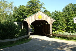
Carries Automobile Crosses North Branch Lamoille River aka Kelly River Locale Waterville, Vermont Maintained by Town of Waterville ID number VT-08-13 Design Covered, Queen post Material Wood Total length 61.1 ft (18.6 m) Width 12.2 ft (3.7 m) Number of spans 1 Load limit 8 tons Vertical clearance 8 ft (2.4 m) Constructed by unknown Construction end 1877[n 1]

Coordinates: 44°41′25″N 72°46′16″W / 44.69028°N 72.77111°WCoordinates: 44°41′25″N 72°46′16″W / 44.69028°N 72.77111°W NRHP Reference#: 74000234 Added to NRHP: December 16, 1974[1] The Church Street Covered Bridge, also called the Village Covered Bridge,[2] is a wooden covered bridge that crosses the North Branch of the Lamoille River (also known as the Kelly River) in Waterville, Vermont off State Route 109 in Waterville, Vermont. It was listed on the National Register of Historic Places in 1974.[1]
The bridge is of Queenpost truss design, with an unknown builder.
Recent history
In 1967, the back wheels of a truck fell through the floor. Subsequently, steel I-beams were installed under the bridge. In 1970, the bridge survived a fire at a nearby house when firefighters hosed it down to prevent it from catching.[3] In 2000, it was completely rebuilt.[n 2]
Notes
References
- ^ a b "National Register Information System". National Register of Historic Places. National Park Service. no date specified. http://nrhp.focus.nps.gov/natreg/docs/All_Data.html.
- ^ U.S. Geological Survey Geographic Names Information System: Church Street Covered Bridge
- ^ Barna, Ed. Covered Bridges of Vermont. The Countryman Press, 1996. ISBN 0881503738
U.S. National Register of Historic Places Topics Lists by states Alabama • Alaska • Arizona • Arkansas • California • Colorado • Connecticut • Delaware • Florida • Georgia • Hawaii • Idaho • Illinois • Indiana • Iowa • Kansas • Kentucky • Louisiana • Maine • Maryland • Massachusetts • Michigan • Minnesota • Mississippi • Missouri • Montana • Nebraska • Nevada • New Hampshire • New Jersey • New Mexico • New York • North Carolina • North Dakota • Ohio • Oklahoma • Oregon • Pennsylvania • Rhode Island • South Carolina • South Dakota • Tennessee • Texas • Utah • Vermont • Virginia • Washington • West Virginia • Wisconsin • WyomingLists by territories Lists by associated states Other Categories:- Waterville, Vermont
- Bridges completed in 1877
- Bridges on the National Register of Historic Places in Vermont
- Covered bridges in Vermont
- Truss bridges
- Wooden bridges in the United States
- Buildings and structures in Lamoille County, Vermont
- Transportation in Lamoille County, Vermont
- Visitor attractions in Lamoille County, Vermont
- Road bridges in Vermont
- Vermont Registered Historic Places building and structure stubs


Wikimedia Foundation. 2010.