- Chai Buri District
-
Chai Buri
ชัยบุรี— Amphoe — Amphoe location in Surat Thani Province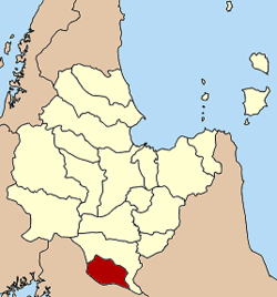
Coordinates: 8°27′46″N 99°4′36″E / 8.46278°N 99.07667°ECoordinates: 8°27′46″N 99°4′36″E / 8.46278°N 99.07667°E Country  Thailand
Province Surat Thani Seat Chai Buri Tambon Muban Amphoe established Area - Total 440.7 km2 (170.2 sq mi) Population (2005) - Total 23,347 - Density 53.0/km2 (137.3/sq mi) Time zone THA (UTC+7) Postal code 84210 Geocode 8418 Chai Buri (Thai: ชัยบุรี) is a district (Amphoe) of Surat Thani Province, Thailand.
Contents
Geography
The district is located in the south of the province. The main river is the Khlong Thorom, which crosses the district from south to north.
Neighboring districts are Phrasaeng to the north and east, Khao Phanom (Krabi Province) to the south and Plai Phraya (also Krabi) to the west.
At the boundary to Plai Phraya is the Khlong Phraya Wildlife Sanctuary.
History
On June 5, 1981 the minor district (King Amphoe) Chai Buri was created by splitting off the tambon Song Phraek and Chai Buri from the district Phrasaeng[1]. The name was chosen in honor of Khun Chai Buri, the first district officer of Phrasaeng.
The minor district started operation on September 10, 1981 with a temporary office in a sermon hall of the temple Wat Samai Suwan, tambon Song Phraek. Wisut Tansutthiwanit became the first leader of the mior district. In 1983 the ministry of interior had chosen two plots of land for the district office building, one in tambon Song Phraek and one in tambon Chai Buri. Though originally the first location was the preferred one, the leader of the minor district, Napha Kanchonkirana, recommended the second site, as the first was prone of floodings and was also not located at the center of the district. In July 1984 the office building in tambon Chai Buri was opened.
On July 4, 1994 the minor district was elevated to a district (amphoe)[2]. Niphan Chonwit became the first district officer.
Administration
The district is subdivided into 4 subdistricts (tambon), which are further subdivided into 37 villages (muban). There are no municipal (thesaban) areas. Each of the tambon is administrated by a Tambon administrative organization (TAO).
No. Name Thai name Villages Inh. 1. Song Phraek สองแพรก 9 5,040 2. Chai Buri ชัยบุรี 10 6,126 3. Khlong Noi คลองน้อย 10 6,217 4. Sai Thong ไทรทอง 8 5,964 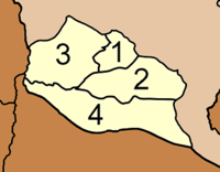
References
- ^ "ประกาศกระทรวงมหาดไทย เรื่อง แบ่งท้องที่อำเภอพระแสง จังหวัดสุราษฎร์ธานี ตั้งเป็นกิ่งอำเภอชัยบุรี" (in Thai). Royal Gazette 94 (42 ง): 754. March 17, 1981. http://www.ratchakitcha.soc.go.th/DATA/PDF/2524/D/042/754.PDF.
- ^ "พระราชกฤษฎีกาตั้งอำเภอเปือยน้อย ... และอำเภอศรีวิไล พ.ศ. ๒๕๓๗" (in Thai). Royal Gazette 111 (21 ก): 32–35. June 3, 1994. http://www.ratchakitcha.soc.go.th/DATA/PDF/2537/A/021/32.PDF.
External links
Mueang Surat Thani · Kanchanadit · Don Sak · Ko Samui · Ko Pha Ngan · Chaiya · Tha Chana · Khiri Rat Nikhom · Ban Ta Khun · Phanom · Tha Chang · Ban Na San · Ban Na Doem · Khian Sa · Wiang Sa · Phrasaeng · Phunphin · Chai Buri · Vibhavadi
Categories:- Amphoe of Surat Thani
- Southern Thailand geography stubs


Wikimedia Foundation. 2010.