- Chai Badan District
-
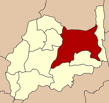
Chai Badan
ชัยบาดาล— Amphoe — Amphoe location in Lopburi Province
Coordinates: 15°12′22″N 101°8′12″E / 15.20611°N 101.13667°ECoordinates: 15°12′22″N 101°8′12″E / 15.20611°N 101.13667°E Country  Thailand
Province Lopburi Seat Lam Narai Area - Total 1,253.0 km2 (483.8 sq mi) Population (2009) - Total 90,224 - Density 70.7/km2 (183.1/sq mi) Time zone THA (UTC+7) Postal code 15130 Geocode 1604 Chai Badan (Thai: ชัยบาดาล) is a district (Amphoe) in eastern part of Lopburi Province, central Thailand. The local people usually call it Lam Narai, as the district center is located in Tambon Lam Narai.
Contents
History
The Chai Badan was an ancient town in the Pa Sak River valley, controlled from Nakhon Ratchasima. In 1914 it was upgraded to be a district of Phetchabun Province. In 1918 it was moved to be part of Sara Buri Province. Finally it became part of Lopburi Province on November 1, 1941.[1]
1943 the district office was moved from Chai Badan subdistrict to Bua Chum subdistrict,[2] which was undone one year after already.[3] In 1960 it was again moved to Bua Chum.[4] The area around the district office was made the new subdistrict Lam Narai in 1970.[5]
Geography
Neighboring districts are (from the east clockwise) Lam Sonthi, Tha Luang, Phatthana Nikhom, Khok Samrong and Khok Charoen of Lopburi Province, and Si Thep of Phetchabun Province.
The Wang Kan Luang waterfall is the most favorite place of Lopburi visitors, also from neighboring provinces.
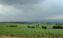 Plantation Valley in rainy season, Amphoe Chai Badan
Administration
The district is subdivided into 17 subdistricts (tambon), which are further subdivided into 136 villages (muban). Lam Narai has subdistrict municipality status (thesaban tambon) and covers part of the tambon Lam Narai and Chai Narai. There are further 16 Tambon administrative organizations (TAO).
No. Name Thai Villages Inh.[6] 1. Lam Narai ลำนารายณ์ 12 17,488 2. Chai Narai ชัยนารายณ์ 6 6,294 3. Sila Thip ศิลาทิพย์ 12 5,635 4. Huai Hin ห้วยหิน 8 2,741 5. Muang Khom ม่วงค่อม 11 5,650 6. Bua Chum บัวชุม 9 8,071 7. Tha Din Dam ท่าดินดำ 6 4,509 8. Makok Wan มะกอกหวาน 3 1,504 9. Sap Takhian ซับตะเคียน 6 4,896 10. Na Som นาโสม 6 2,655 11. Nong Yai To หนองยายโต๊ะ 8 4,000 12. Ko Rang เกาะรัง 10 6,510 14. Tha Manao ท่ามะนาว 8 3,224 17. Nikhom Lam Narai นิคมลำนารายณ์ 9 4,423 18. Chai Badan ชัยบาดาล 8 6,334 19. Ban Mai Samakkhi บ้านใหม่สามัคคี 6 2,957 22. Khao Laem เขาแหลม 8 3,333 The missing numbers belong to tambon which now form Lam Sonthi district
References
- ^ "พระราชบัญญัติเปลี่ยนแปลงเขตจังหวัดลพบุรีและจังหวัดสระบุรี พุทธศักราช ๒๔๘๔" (in Thai). Royal Gazette 58 (0 ก): 1379–1381. October 14 1941. http://www.ratchakitcha.soc.go.th/DATA/PDF/2484/A/1379.PDF.
- ^ "ประกาศกระทรวงมหาดไทย เรื่อง ย้ายที่ว่าการอำเภอชัยบาดาล จังหวัดลพบุรี" (in Thai). Royal Gazette 60 (56 ง): 3385. 1943-10-19. http://www.ratchakitcha.soc.go.th/DATA/PDF/2486/D/056/3385.PDF.
- ^ "ประกาศกระทรวงมหาดไทย เรื่อง ย้ายที่ว่าการอำเภอชัยบาดาล จังหวัดลพบุรี" (in Thai). Royal Gazette 61 (77 ง): 2445–2446. 1944-12-26. http://www.ratchakitcha.soc.go.th/DATA/PDF/2487/D/077/2445_1.PDF.
- ^ "ประกาศกระทรวงมหาดไทย เรื่อง ย้ายที่ว่าการอำเภอไชยบาดาลและสถานีตำรวจภูธร" (in Thai). Royal Gazette 77 (47 ง): 1509. 1960-06-07. http://www.ratchakitcha.soc.go.th/DATA/PDF/2503/D/047/1509.PDF.
- ^ "ประกาศกระทรวงมหาดไทย เรื่อง ตั้งและเปลี่ยนแปลงเขตตำบลในท้องที่อำเภอชัยบาดาล จังหวัดลพบุรี" (in Thai). Royal Gazette 87 (85 ง): 2539–2545. 1970-09-08. http://www.ratchakitcha.soc.go.th/DATA/PDF/2513/D/085/2539.PDF.
- ^ "Population statistics 2009". Department of Provincial Administration. http://www.dopa.go.th/xstat/p5216_01.html.
External links
- amphoe.com (Thai)
Lopburi Main article 
Capital Districts (amphoe) Mueang Lopburi · Ban Mi · Chai Badan · Khok Charoen · Khok Samrong · Lam Sonthi · Nong Muang · Phatthana Nikhom · Sa Bot · Tha Luang · Tha Wung
Royalty Related topics History · King Narai's Palace · Pasak Jolasit Dam · Suranarai Road · Lopburi River · Pa Sak River · Lopburi FC · Bang Kham River
Neighboring areas Phetchabun · Chaiyaphum · Nakhon Ratchasima · Saraburi · Phra Nakhon Si Ayutthaya · Ang Thong · Sing Buri · Nakhon SawanCategories:- Amphoe of Lopburi
- Central Thailand geography stubs


Wikimedia Foundation. 2010.