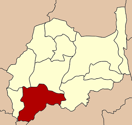
- Mueang Lopburi District
-
Mueang Lopburi
เมืองลพบุรี— Amphoe — Amphoe location in Lopburi Province
Coordinates: 14°47′53″N 100°39′13″E / 14.79806°N 100.65361°ECoordinates: 14°47′53″N 100°39′13″E / 14.79806°N 100.65361°E Country  Thailand
Province Lopburi Seat Thale Chup Son Tambon Muban Amphoe established Area – Total 565.6 km2 (218.4 sq mi) Population (2007) – Total 247,842 – Density 438.2/km2 (1,134.9/sq mi) Time zone THA (UTC+7) Postal code 15000 Geocode 1601 Mueang Lopburi (Thai: เมืองลพบุรี) is the capital district (Amphoe Mueang) of Lopburi Province, central Thailand.
Contents
History
See also: Lopburi Province#HistoryLopburi is an ancient city. In Khmer era, it was Lavo or Lava Pura, the important city of the eastern part of Chao Phraya river valley. In Ayuthaya kingdom, it was the northeastern frontier city. The glorious period of Lopburi was during the reign of King Narai the Great. He stayed in his palace 8–9 months a year, making Lopburi was the 2nd capital of the kingdom. After his reign, the city became nearly deserted, only to be enriched again when King Mongkut visited and renovated King Narai's Palace.
Field Marshal Plaek Phibunsongkhram set up Lopburi as the military center of Thailand. He relandscaped the Lopburi city, with its modern center located about 4 km east from the historical center. His building style, Art Deco is showing along Narai Maharat road.
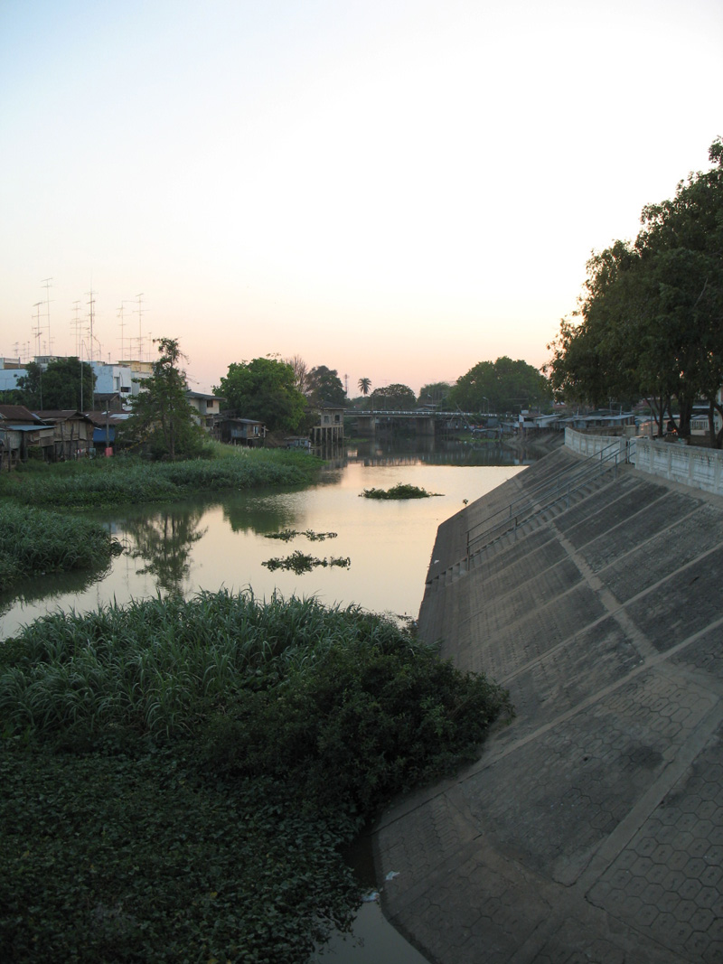
 Lopburi River
Geography
The southwestern part of the district is very low alluvial plain. The rest is intermixed between plains and hills. Beside the Lopburi River, the important water resource are the Sap Lek Reservoir and Khlong Raphiphat. Neighboring districts are (from the west clockwise) Tha Wung, Ban Mi, Khok Samrong and Phatthana Nikhom of Lopburi Province, Phra Phutthabat, Nong Don and Don Phut of Saraburi Province, Ban Phraek of Ayutthaya Province, and Chaiyo of Ang Thong Province.
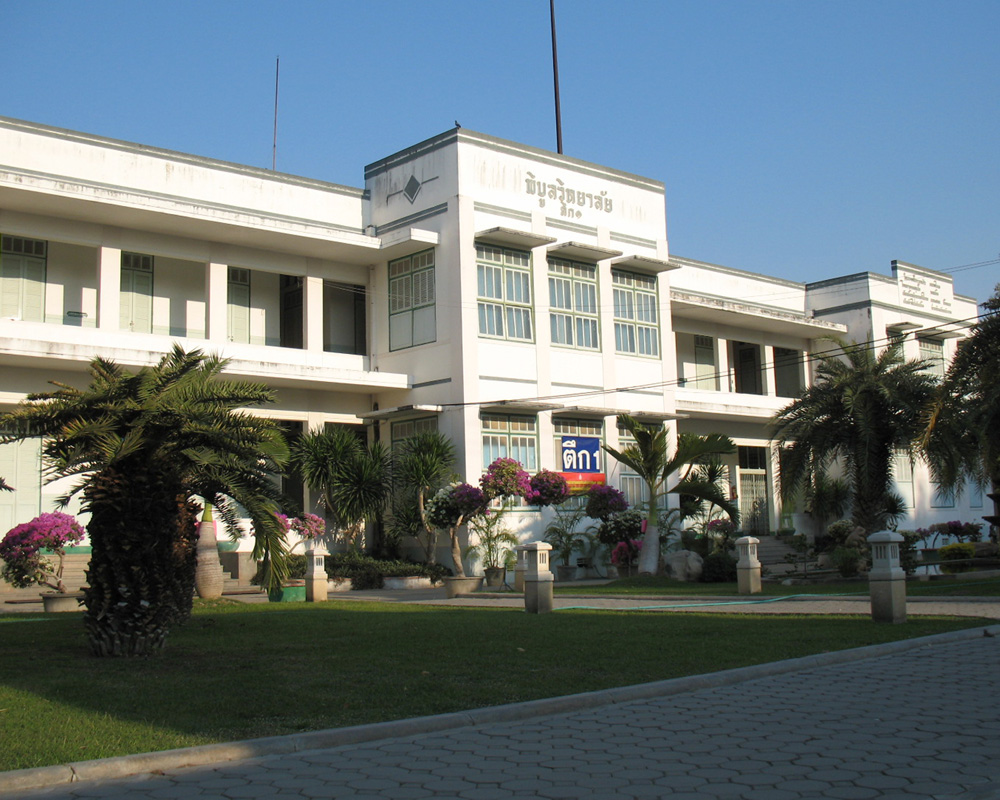
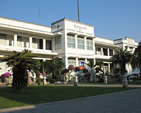 Pibul Wittayalai School Building 1, Art Deco style
Administration
The district is subdivided into 24 subdistricts (tambon), which are further subdivided into 223 villages (muban). The town (thesaban mueang) Lopburi covers the complete tambon Tha Hin and parts of Thale Chup Son. There are two further subdistrict municipalities (thesaban tambon) - Khao Phra Ngam covering the complete tambon Khao Phra Ngam, and Khok Tum covering the tambon Khok Tum and Nikhom Sang Ton Eng. There are further 19 Tambon administrative organizations (TAO).
No. Name Thai Inh. 1. Thale Chup Son ทะเลชุบศร 34,742 2. Tha Hin ท่าหิน 8,487 3. Kok Ko กกโก 8,304 4. Kong Thanu โก่งธนู 4,893 5. Khao Phra Ngam เขาพระงาม 28,664 6. Khao Sam Yot เขาสามยอด 28,262 7. Khok Kathiam โคกกะเทียม 4,833 8. Khok Lam Phan โคกลำพาน 3,554 9. Khok Tum โคกตูม 15,504 10. Ngio Rai งิ้วราย 5,592 11. Don Pho ดอนโพธิ์ 3,582 12. Talung ตะลุง 5,218 14. Tha Khae ท่าแค 13,666 15. Tha Sala ท่าศาลา 12,515 16. Nikhom Sang Ton Eng นิคมสร้างตนเอง 11,737 17. Bang Khan Mak บางขันหมาก 8,935 18. Ban Khoi บ้านข่อย 3,081 19. Thai Talat ท้ายตลาด 3,039 20. Pa Tan ป่าตาล 12,523 21. Phrommat พรหมมาสตร์ 6,779 22. Pho Kao Ton โพธิ์เก้าต้น 10,540 23. Pho Tru โพธิ์ตรุ 2,721 24. Si Khlong สี่คลอง 1,067 25. Thanon Yai ถนนใหญ่ 9,604 Geocode 13 not used.
External links
- amphoe.com (Thai)
Lopburi Main article 
Capital Districts (amphoe) Mueang Lopburi · Ban Mi · Chai Badan · Khok Charoen · Khok Samrong · Lam Sonthi · Nong Muang · Phatthana Nikhom · Sa Bot · Tha Luang · Tha Wung
Royalty Related topics History · King Narai's Palace · Pasak Jolasit Dam · Suranarai Road · Lopburi River · Pa Sak River · Lopburi FC · Bang Kham River
Neighboring areas Phetchabun · Chaiyaphum · Nakhon Ratchasima · Saraburi · Phra Nakhon Si Ayutthaya · Ang Thong · Sing Buri · Nakhon SawanCategories:- Amphoe of Lopburi
- Central Thailand geography stubs
Wikimedia Foundation. 2010.