- Mueang Mae Hong Son District
-
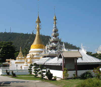
 Wat Phra That Chong Kham
Mueang Mae Hong Son
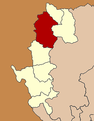
เมืองแม่ฮ่องสอน— Amphoe — Amphoe location in Mae Hong Son Province
Coordinates: 19°18′14″N 97°58′38″E / 19.30389°N 97.97722°ECoordinates: 19°18′14″N 97°58′38″E / 19.30389°N 97.97722°E Country  Thailand
Province Mae Hong Son Seat Chong Kham Area – Total 2,483.115 km2 (958.7 sq mi) Population (2010) – Total 53,333 – Density 22.2/km2 (57.5/sq mi) Time zone THA (UTC+7) Postal code 58000 Geocode 5801 Mueang Mae Hong Son (Thai: เมืองแม่ฮ่องสอน) is the capital district (Amphoe Mueang) of Mae Hong Son Province, northern Thailand.
Contents
History
The Interior Ministry upgraded Mueang Mae Hong Son to be a 4th class city under Monthon Phayap on May 10, 1910.[1] It then consisted of the four districts Mueang Mae Hong Son, Mueang Yuam (now Mae Sariang district), Pai and Khun Yuam.
In 1917, the district was renamed from Mueang to Muai To (ม่อยต่อ).[2] In 1938 it was renamed to Mueang Mae Hong Son.[3] The north-eastern part of the district was split off in 1987 and formed the new district Pang Mapha.[4]
Geography
Neighboring are (from south clockwise) Khun Yuam of Mae Hong Son Province, Kayah State of Myanmar, Pang Mapha, Pai of Mae Hong Son Province again and Galyani Vadhana and Mae Chaem of Chiang Mai Province.
The Namtok Mae Surin National Park office is located in the district.
Administration
The district is subdivided into 7 subdistricts (tambon), which are further subdivided into 70 villages (muban). Mae Hong Son itself is a town (thesaban mueang) which covers the complete tambon Chong Kham. Each of the other 6 tambon is administrated by a Tambon administrative organization (TAO).
No. Name Thai Villages Inh.[5] 1. Chong Kham จองคำ - 6,534 2. Huai Pong ห้วยโป่ง 15 6,948 3. Pha Bong ผาบ่อง 12 9,519 4. Pang Mu ปางหมู 13 14,725 5. Mok Champae หมอกจำแป่ 9 6,936 6. Huai Pha ห้วยผา 8 5,431 9. Huai Pu Ling ห้วยปูลิง 11 3,240 Missing numbers are tambon which now form Pang Mapha district.
See also
References
- ^ "ประกาศกระทรวงมหาดไทย ประกาศยกเมืองแม่ฮ่องสอนเป็นเมืองจัตวารวมอยู่ในมณฑลพายัพ" (in Thai). Royal Gazette 27 (0 ง): 198–199. 1910-07-15. http://www.ratchakitcha.soc.go.th/DATA/PDF/2453/D/198.PDF.
- ^ "ประกาศกระทรวงมหาดไทย เรื่อง เปลี่ยนชื่ออำเภอ" (in Thai). Royal Gazette 34 (0 ก): 40–68. 1917-04-29. http://www.ratchakitcha.soc.go.th/DATA/PDF/2460/A/40.PDF.
- ^ "พระราชกฤษฎีกาเปลี่ยนนามจังหวัด และอำเภอบางแห่ง พุทธศักราช ๒๔๘๑" (in Thai). Royal Gazette 55 (0 ก): 658–666. 1938-11-14. http://www.ratchakitcha.soc.go.th/DATA/PDF/2481/A/658.PDF.
- ^ "ประกาศกระทรวงมหาดไทย เรื่อง แบ่งเขตท้องที่อำเภอเมืองแม่ฮ่องสอน จังหวัดแม่ฮ่องสอน ตั้งเป็นกิ่งอำเภอปางมะผ้า" (in Thai). Royal Gazette 104 (67 ง): 2485. April 9 1987. http://www.ratchakitcha.soc.go.th/DATA/PDF/2530/D/067/2485.PDF.
- ^ "Population statistics 2010". Department of Provincial Administration. http://203.113.86.149/xstat/p5358_01.html.
External links
- amphoe.com (Thai)
Mueang Mae Hong Son · Khun Yuam · Pai · Mae Sariang · Mae La Noi · Sop Moei · Pang Mapha
Categories:- Mae Hong Son
- Amphoe of Mae Hong Son
- Northern Thailand geography stubs
Wikimedia Foundation. 2010.