- Nakhon Ratchasima
-
This article is about the city Nakhon Ratchasima. For other uses, see Nakhon Ratchasima (disambiguation).For the cat breed originating from this city, see Korat.
City of Nakhon Ratchasima
เทศบาลนครนครราชสีมา
Korat CityAerial view of the city Nickname(s): Khorat / Korat Coordinates: 14°58′50″N 102°6′00″E / 14.98056°N 102.1°E Country  Thailand
District Mueang Nakhon Ratchasima Province Nakhon Ratchasima - Settled AD.1656 (Ayutthaya Period) - as Sanitary districts January 3, 1908 - as Municipality December 7, 1935 Government – Type City Municipality – Mayor Surawuth Cherdchai – Municipal Clerk Arlom Tangtaku Area – City 37.5 km2 (14.5 sq mi) – Land 37.4 km2 (14.45 sq mi) – Metro 767.98 km2 (296.52 sq mi) Population (2011) – City 166,217 – Density 4,432.45/km2 (11,480/sq mi) – Metro 444,023 – Metro density 578.17/km2 (1,497.5/sq mi) – Demonym Korat Time zone Thailand (UTC+7) Area code(s) 044 Nakhon Ratchasima (Thai: นครราชสีมา, pronounced [náʔkʰɔːn râːt.tɕʰa.sǐː.maː]) or (Khmer: Nokor Reach Seyma) is a city (thesaban nakhon) in the north-east (Isan) of Thailand and gateway to Isan. It is the capital of the Nakhon Ratchasima Province and Nakhon Ratchasima district. As of August 16, 2010,[1] the municipal area has a population of 142,645.
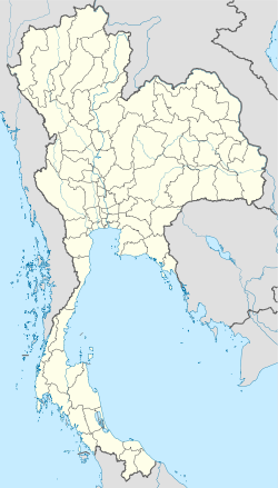
The city is also commonly known as Korat (RTGS Khorat, โคราช), a short version of the full name. It is located at the western edge of the Khorat Plateau and historically marked the boundary between the Lao and Siamese territory, however now is considered a gateway to the Northeast (Isan). Its geographical location is 14°58.5′N 102°6′E / 14.975°N 102.1°ECoordinates: 14°58.5′N 102°6′E / 14.975°N 102.1°E.
Nakhon Ratchasima is also the center of the Nakhon Ratchasima Metropolitan Area.
Contents
History
Archeological evidence suggests that there were two ancient towns that later became named Sema and Nakhon Raj which currently are in Sung Noen district, 32 km west of present-day Nakhonratchasima (Korat). Nakhon means capital, Raj means kingdom or state in Hindi languages.
Prior to the fourteenth century, the area of Nakhon Ratchasima was under the Khmer empire suzerainty (known in Khmer as Nokor Reach Seyma / Nokor Reach Borei, and Koreach) while another town to the north, Phimai, was likely more important.
Narai, king of the Ayutthaya from 1656 to 1688, ordered a new city built, to serve as a stronghold on Ayutthaya's northeastern frontier. Nakhon Ratchasima was subsequently mentioned in Siamese chronicles and legal documents as a 'second - class' city of the kingdom. A governor was named who ruled the city as a dynasty.
In the aftermath of the final phase of the Ayutthaya kingdom that had ended with its complete destruction by the Burmese in 1767, Prince Theppipit, a son of King Boromakot, attempted to set himself up the ruler of Phimai holding sway over Korat and other eastern provinces. King Taksin of the successor Thonburi Kingdom (1768–1782) sent two of his generals, the brothers Thong Duang and Boonma to defeat the prince, who was then executed in 1768. Thong Duang became King Rama I of the kingdom in 1782, and Korat became his strategic stronghold on the northeastern frontier supervising Lao and Khmer tributary states.
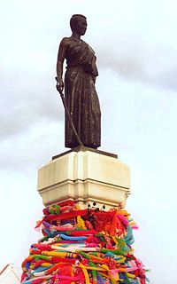
In 1826, Vientiane King Chao Anouvong perceived Siam as weakened, and attacked Korat in the Laotian Rebellion against King Rama III that was to rage on for two years.[2] Lady Mo, the wife of the deputy governor at the time, is credited with having freed the city from Anouvong's army, and has been honored with a statue in the center of downtown Korat. The old, walled town east of the monument was designed and built by a French engineer who is believed to be the one who also built Naraimaharaj Palace in Lopburi. The French-based design is reflected in the moat system that surrounds the innermost portion of the city.
Nakhon Ratchasima continued to be an important political and economic center in the northeastern region under the Monthon administrative reforms of the late nineteenth century. In November 1900, the Royal State Railways of Siam began operation of the Nakhon Ratchasima Line from Bangkok with Korat Station as its terminus. The Ubon Ratchathani Line to the town of Warin opened 1 November 1922. The Thanon Chira Junction to Khon Kaen opened on 1 April 1933. Korat station was changed to Nakhon Ratchasima Railway Station in 1934.
In October 1933, after the Siamese revolution of 1932 had ended the absolute monarchy, the city became the headquarters of the Boworadet Rebellion, an abortive uprising against the new government in Bangkok.
In April 1981 during another attempted coup, the government, together with the royal family, took refuge in Korat.
From 1962 - 1976, Korat Royal Thai Air Force Base was host to components of the Royal Thai Air Force, the United States Air Force, and a complement of the Royal New Zealand Air Force (RNZAF). After the US withdrawal in 1976, the Thai Air Force assumed full control. During the 1980s and early 1990s, the airfield was jointly operated as a civil airport for Nakhon Ratchasima. This was ended with the opening of Nakhon Ratchasima Airport in the early 1990s.
 Korat City Panorama view from Fort Suranaree Hospital
Transportation
Nakhon Ratchasima is connected with the northeastern railway line, connecting Bangkok with Ubon Ratchathani and Nong Khai. Also passing the city is Mittraphap Road (Thailand Route 2). 26 km east of the city is the Nakhon Ratchasima Airport.
As of 30 November 2006, the airport does not handle passenger traffic, and shipping has not been seen as a major commercial possibility. Passenger service has been attempted many times with financial failure (charges were as low as 99 baht to fly to Bangkok), authorities are still discussing ways to make the over 400 million baht investment several years ago a paying venture.
Commencing August 19, 2010, Happy Air (HPY) plans to fly from Nakhon Ratchasima to Chiang Mai and Bangkok with the 33-seat Swedish built Saab 340.
Major Points of Interest
- Korat Royal Thai Air Force Base was used by the United States Air Force during the Vietnam War. It is located some 8 km south of the city.
- Korat Zoo - The zoo is first-class. Admission is 70B for Thais, 100B for foreign tourists.[3] The zoo is located about 13 km south of the city on highway 304.
- Thao Suranaree Monument - This is currently under renovation. Lady Mo's statue itself is in place, and vendors providing flowers and incense etc. are currently nearby in makeshift stalls.
- Wat Salaloi
- His Majesty the King's 80th Birthday Anniversary, 5th December 2007 Sports Complex is a multi-use stadium in Nakhon Ratchasima, Thailand, that was completed in 2007. It was used for track & field events, football matches and hosted the opening and closing ceremonies for the 2007 Southeast Asian Games. In 2008, Nakhon Ratchasima FC, the city's only football team, moved in to the stadium.
Korat has becoming increasingly attractive to foreigners over the last five years, with growing numbers from mostly North America and Europe moving to the province. Still rustic, with cheap housing and land prices, the province is located only three hours' drive from Bangkok, (by bus or train) and as its Gateway to the Northeast moniker suggests, Korat connects the other 18 NE Thailand provinces with the central region by rail and highway.
Weather
There are generally three seasons in the region: Hot (February - May), Rainy (May - October), Cold (October - February). In the cold season, temperatures in Korat proper will drop to about 60 degrees F, and in rural areas, down to the low fifties.
Climate data for Nakhon Ratchasima Month Jan Feb Mar Apr May Jun Jul Aug Sep Oct Nov Dec Year Average high °C (°F) 30.9
(87.6)33.6
(92.5)35.8
(96.4)36.6
(97.9)35.1
(95.2)34.4
(93.9)33.9
(93.0)33.2
(91.8)32.2
(90.0)30.9
(87.6)29.7
(85.5)29.1
(84.4)33.0 Average low °C (°F) 17.9
(64.2)20.5
(68.9)22.8
(73.0)24.5
(76.1)24.7
(76.5)24.8
(76.6)24.3
(75.7)24.2
(75.6)23.7
(74.7)22.9
(73.2)20.5
(68.9)17.6
(63.7)22.4 Precipitation mm (inches) 5.9
(0.232)17.8
(0.701)37.1
(1.461)63.5
(2.5)140.5
(5.531)108.3
(4.264)113.7
(4.476)146.2
(5.756)221.6
(8.724)143.4
(5.646)27.3
(1.075)18.3
(0.72)1,044.0
(41.102)Source: World Weather Information Service [4] Education
Universities
There are 4 universities in the area.
- Suranaree University of Technology
- Nakhon Ratchasima Rajabhat University
- Rajamangala University of Technology Isan
- Vongchavalitkul University
Schools
Elementary Schools
- Ruammit School
- Sukhanaree School
- Anuban Nakhonratchasima School
- Wat Sakaew School
- Muang Nakhonratchasima School
High Schools
- Suratham Pitak School
- Rajsima Wittayalai School
- Suranaree Witthaya School
- Boonwattana School
- Saint Mary's College Nakhon Ratchasima
- St.Mary Business Administration College
- Assumption School Nakhon Ratchasima
Facilities
Hospitals
- Fort Suranaree Hospital
- Saint Mary's Hospital
- Korat Memorial Hospital
- Bangkok-Ratchasima Hospital
- Po-Pat Hospital
- Maharat Nakhon Ratchasima Hospital
- The Golden Gate Hospital
Hotels
- Best Hotel
- Sima-Thani Hotel
- Dusit Princess Korat Hotel
- Raya Grand Hotel
- City Park Hotel [1]
- Rachaphruk Grand Hotel
- Hermitage Hotel
- Sri Pattana Hotel
- Panjadara Hotel
Shopping Center & Department Store
- The Mall Nakhon Ratchasima including Home Pro & EGV Cinemas. Located on Mittraphap Road.
- Central Festival Nakhon Ratchasima including SFX & SF Strike Bowl. (Plan of Developing Business)
- Big C Supercenter. Located on Mittraphap-Nong Khai Road.
- Klang Plaza Atsadang. Located on Atsadang Road.
- Klang Plaza Chomsurang. Located on Chomsurangyat Road.
- Klang Villa Suranarai Road.
- IT City. Located on Mittraphap Road.
- Makro. Located on Mittraphap-Nong Khai Road.
- Tesco Lotus Nakhon Ratchasima 1 Hypermarket. Located on Mittraphap Road.
- Tesco Lotus Nakhon Ratchasima 2 Hypermarket. ==(Under Construction)==
- Home Pro Nakhon Ratchasima. Located on Bypass Korat
Local media
Newspapers
- The Korat Daily. Thai language.
- The Korat Post. English-language monthly.
See also
- Nakhon Ratchasima Province
- Nakhon Ratchasima Metropolitan Area
- List of Cities, Towns and Townships in Nakhon Ratchasima Province
- Korat (cat)
References
- ^ Department of Provincial Administration, Ministry of Interior, Royal Thai Government. As of August 16, 2010
- ^ Chandler, David P.; Roff, William R.; Smail, John R.W.; Steinberg, David Joel; Taylor, Robert H.; Woodside, Alexander & Wyatt, David K. (1987) [1971] "13 Siam, 1767–1868" in David, Steinberg In search of Southeast Asia (Revised ed.) Honolulu: University of Hawaii Press pp. 113–117 ISBN 0-8248-1110-0 OCLC 500095794 Lay summary (Jan 08, 2008)
- ^ http://stuckinthailand.com/korat/trip-to-the-zoo-in-korat
- ^ "World Weather Information Service - Nakhon Ratchasima". http://www.worldweather.org/089/c00573.htm. Retrieved 2008-09-02.
External links
- Happykorat.com : Central web and Information of Nakhonratchasima (Business & SMEs)
- City of Nakhon Ratchasima Municipality
- 24th Southeast Asian Games Nakhon Ratchasima 2007 Website
- Photo collections from 1966/67
- Information, news and maps of Nakhon Ratchasima
- Nakhon Ratchasima Football Club website (English language)
Categories:- Nakhon Ratchasima
- Nakhon Ratchasima Province
- Isan
- Populated places in Thailand
- Populated places established in 1656
Wikimedia Foundation. 2010.


