- Nakhon Ratchasima Metropolitan Area
-
The Nakhon Ratchasima Metropolitan Area (Thai: เขตนครนครราชสีมาและปริมณฑล) is the urban sprawl of the city of Nakhon Ratchasima. It covers in Mueang Nakhon Ratchasima district (Except tambon Nong Khai Nam, Chai Mongkhon and Phon Krang), parts of Kham Thale So district (Only tambon Kham Thale So and Pong Daeng), and parts of Sung Noen district (Only tambon Na Klang and Kud Chik) with 767.98 km² of land area and about 444,023 inhabitants (registered).
Contents
Population[1]
The Nakhon Ratchasima metropolitan area has an only registered population of 444,023, but an estimated real population are over 500,000.
-
-
- Amphoe Mueang Nakhon Ratchasima (except in tambon Nong Khai Nam, Chai Mongkhon and Phon Krang) has the population of 254,683 in the city and 161,791 in suburban.
- Amphoe Kham Thale So (in Tambon Kham Thale So and Pong Daeng only) has the population of 4,067 in the city and 8,129 in the suburban.
- Amphoe Sung Noen (in Tambon Na Klang and Kud Chik only) has the population of 2,623 in the city and 8,253 in suburban.
-
The area covers parts of 3 districts in the province, namely
-
-
- Mueang Nakhon Ratchasima district (Excluding Tambon Nong Khai Nam, Chai Mongkhon and Phon Krang) with population 420,951
- Sung Noen District (Only tambon Na Klang and Kud Chik) with population 10,876
- Kham Thale So District (Only tambon Kham Thale So and Pong Daeng) with population 12,196
-
District Area
(km2)Population (2008)
(registered)Density
(inh./km2)Mueang Nakhon Ratchasima
(Excluding : Nong Khai Nam, Chai Mongkhon and Phon Krang subdistrict)633.33420,951664Sung Noen
(Only : Na Klang and Kud Chik Subdistrict)65.1710,876167Kham Thalae So
(Only : Kham Thalae So and Pong Dang Subdistrict)69.4812,196176Total767.98444,023578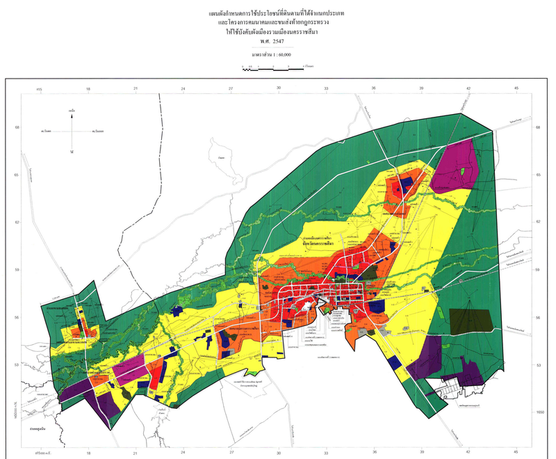

Nakhon Ratchasima Principle City Plan Diagram -
- COLOR LEGEND
- Yellow Low-density Residencial.
- Orange Medium-density Residencial.
- Red High-density Commercial and Residencial.
- Indigo Industrial and Warehouse.
- Purple Specific Industrial.
- Green Rural and Agriculture.
- Light Green Open space for recreation and environment.
- Olive Green Educational Institution.
- Light Grey Religious Institution.
- Blue Government Institution, Public Utility and Public Assistance.
- Pink Transportation Network.
- COLOR LEGEND
Population in Principle City Plan : Mueang Nakhon Ratchasima District.
( Excluding : Nong Khai Nam, Chai Mongkhon and Phon Krang subdistrict. )Subdistrict Name Area
(km2)Municipal Pop. (2008)
(registered)*SAO.[2] Pop. (2008)
(registered)Grand Total Nai Mueang 37.50 166,217 - 166,217 Cho Ho 36.47 14,421 11,849 26,270 Pho Klang 55.23 24,940 - 24,940 Hua Talae 18.43 23,543 - 23,543 Nong Phai Lom 17.89 20,171 - 20,171 Khok Kruat 67.17 7,204 12,193 19,397 Ban Mai 19.55 - 17,291 17,291 Suranaree 49.90 - 15,890 15,890 Nong Bua Sala 36.61 - 15,353 15,353 Nong Rawiang 54.77 - 10,685 10,685 Nong Chabok 23.56 - 10,739 10,739 Khok Sung 30.56 9,453 - 9,453 Paru Yai 16.63 9,158 - 9,158 Ban Koh 11.30 - 9,878 9,878 Muen Wai 9.76 - 9,812 9,812 Putsa 39.46 - 9,433 9,433 Ban Pho 44.36 - 8,685 8,685 Maroeng 10.25 - 6,877 6,877 Nong Krathum 18.50 - 6,483 6,483 Si Mum 15.0 - 6,210 6,210 Talat 22.20 - 5,589 5,589 Phanao 18.16 - 4,824 4,824 Total 633.33 264,895 172,003 436,898 * SAO : Subdistrict Administrative Organization[2]
Population in Principle City Plan : Sung Noen District.
( Only : Na Klang, Kud Chik subdistrict. )Subdistrict Name Area
(km2)Municipal Pop. (2008)
(registered)*SAO.[2] Pop. (2008)
(registered)Grand Total Na Klang 52.19 - 5,951 5,951 Kud Chik 12.27 2,623 2,302 4,925 Total 65.17 2,623 8,253 10,876 * SAO : Subdistrict Administrative Organization[2]
Population in Principle City Plan : Kham Talae So District.
( Only : Kham Talae So, Pong Dang subdistrict. )Subdistrict Name Area
(km2)Municipal Pop. (2008)
(registered)*SAO.[2] Pop. (2008)
(registered)Grand Total Kham Talae So 39.22 4,067 3,033 7,100 Pong Dang 30.26 - 5,096 5,096 Total 69.48 4,067 8,129 12,196 * SAO : Subdistrict Administrative Organization[2]
See also
References
- ^ Local Administration Information 2008, Department of Provincial Administration , Ministry of Interior, Royal Thai Government
- ^ a b c d e f นามสงเคราะห์หน่วยราชการ และตำแหน่ง, Department of Provincial Administration , Ministry of Interior
External links
Categories:- Nakhon Ratchasima
- Nakhon Ratchasima Province
- Metropolitan areas of Thailand
- Isan geography stubs
-

Wikimedia Foundation. 2010.