- Don Sak District
-
Don Sak
ดอนสัก— Amphoe — Amphoe location in Surat Thani Province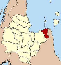
Coordinates: 9°18′50″N 99°41′25″E / 9.31389°N 99.69028°ECoordinates: 9°18′50″N 99°41′25″E / 9.31389°N 99.69028°E Country  Thailand
Province Surat Thani Seat Don Sak Tambon Muban Amphoe established Area - Total 460.9 km2 (178 sq mi) Population (2005) - Total 35,468 - Density 77.0/km2 (199.4/sq mi) Time zone THA (UTC+7) Postal code 84220 Geocode 8403 Don Sak (Thai: ดอนสัก) is a district (Amphoe) in eastern Surat Thani Province. The ferry port to Samui Island is located in the district.
Neighboring districts are (from the east clockwise) Khanom and Sichon (both in Nakhon Si Thammarat Province) and the district Kanchanadit. To the north is the Gulf of Thailand, with islands belonging to the Ko Samui district.
Contents
History
Originally, the area of the district was part of Sichon district, Nakhon Si Thammarat province. In 1929 the two subdistricts Don Sak and Chaiyakhram were reassigned to Kanchanadit district.[1] The district was created as a minor district (King Amphoe) on March 24, 1969 by splitting the two tambon Don Sak and Chonlakhram from Kanchanadit district.[2] The citizen of tambon Chaiyakhram then asked to be included into the new district as well, which was done on September 1 of the same year.[3] On November 16, 1971 it was promoted to full district status.[4] The fourth tambon Pak Prak was created on July 14 1978 from tambon Don Sak and Chaiyakhram.[5]
Administrative divisions
The district Don Sak is subdivided into 4 subdistricts (tambon), which are further subdivided into 40 villages (muban). All four tambon are administrated by a Tambon Administrative Organization (TAO); Don Sak itself has township (thesaban tambon) status and covers part of the tambon Don Sak.
No. Name Thai name Villages Inh. 1. Don Sak ดอนสัก 14 18,634 2. Chonlakhram ชลคราม 6 2,250 3. Chaiyakhram ไชยคราม 5 2,011 4. Pak Prak ปากแพรก 15 12,573 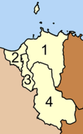
Sights
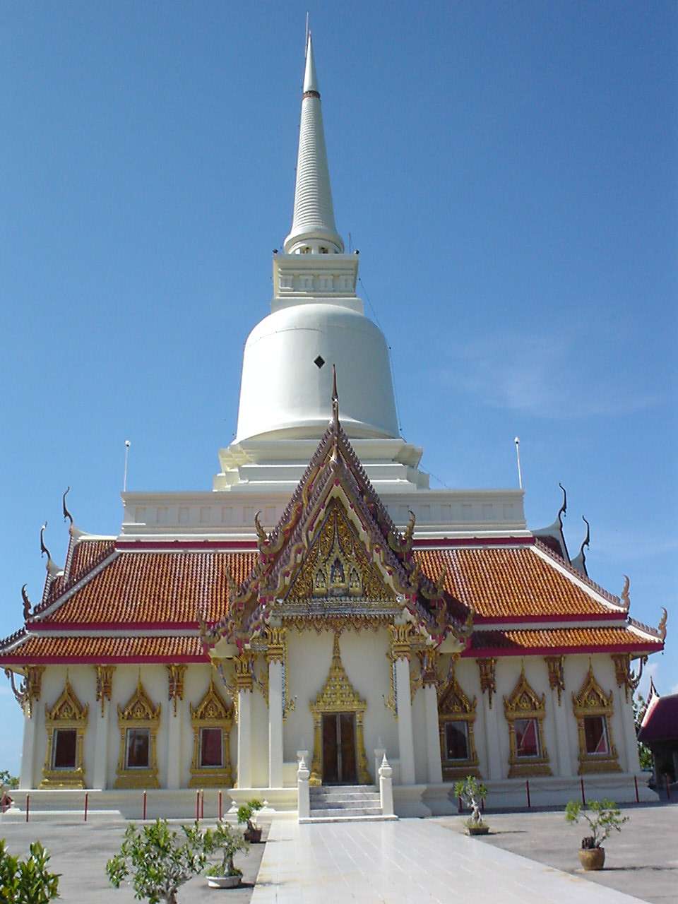
 Wat Khao Suwan Pradit
Wat Khao Suwan Pradit (Thai: วัดเขาสุวรรณประดิษฐ์) is a buddhist temple located on a hill about 1 kilometer from the town Don Sak. The temple was founded in 1982 by Luang Pho Choi, a highly revered monk of southern Thailand. On top of the hill is a 45 meter high chedi, which also contains Buddha relics which came from Wat Phra Kiat (Amphoe Hot, Chiang Mai Province); the platform around the chedi also offers a great view over the town and the Gulf of Thailand.
References
- ^ "แจ้งความกระทรวงมหาดไทย เรื่อง โอนตำบล" (in Thai). Royal Gazette 46 (0 ง): 149. 1929-04-14. http://www.ratchakitcha.soc.go.th/DATA/PDF/2472/D/149.PDF.
- ^ "ประกาศกระทรวงมหาดไทย เรื่อง แบ่งท้องที่ตั้งเป็นกิ่งอำเภอ" (in Thai) (PDF). Royal Gazette 86 (27 ง): 1206. April 1 1969. http://www.ratchakitcha.soc.go.th/DATA/PDF/2512/D/027/1206.PDF.
- ^ "ประกาศกระทรวงมหาดไทย เรื่อง เปลี่ยนแปลงเขตกิ่งอำเภอดอนสัก อำเภอกาญจนดิษฐ จังหวัดสุราษฎร์ธานี" (in Thai) (PDF). Royal Gazette 86 (80 ง): 2851. September 16 1969. http://www.ratchakitcha.soc.go.th/DATA/PDF/2512/D/080/2851.PDF.
- ^ "พระราชกฤษฎีกาตั้งอำเภอปลาปาก อำเภอเชียงกลาง อำเภอปากชม อำเภอบ้านม่วง อำเภอพังโคน อำเภอดอนสัก อำเภอพนม อำเภอเวียงสระ อำเภอสังคม และอำเภอหัวตะพาน พ.ศ. ๒๕๑๔" (in Thai) (PDF). Royal Gazette 88 (123 ก): 745–748. November 16 1971. http://www.ratchakitcha.soc.go.th/DATA/PDF/2514/A/123/745.PDF.
- ^ "ประกาศกระทรวงมหาดไทย เรื่อง ตั้งและเปลี่ยนแปลงเขตตำบลในท้องที่อำเภอเวียงสระ และอำเภอดอนสัก จังหวัดสุราษฎร์ธานี" (in Thai) (PDF). Royal Gazette 95 (76 ง): 2456–2559. August 1 1978. http://www.ratchakitcha.soc.go.th/DATA/PDF/2521/D/076/2456.PDF.
External links
- amphoe.com (Thai)
- http://donsak.org Website of district (Thai)
- http://www.donsakcity.go.th Website of Don Sak municipality (Thai)
Mueang Surat Thani · Kanchanadit · Don Sak · Ko Samui · Ko Pha Ngan · Chaiya · Tha Chana · Khiri Rat Nikhom · Ban Ta Khun · Phanom · Tha Chang · Ban Na San · Ban Na Doem · Khian Sa · Wiang Sa · Phrasaeng · Phunphin · Chai Buri · Vibhavadi
Categories:- Amphoe of Surat Thani


Wikimedia Foundation. 2010.