- Arwal
-
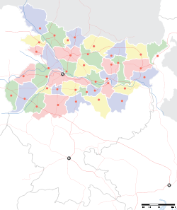
Arwal — village — Coordinates 25°15′N 84°41′E / 25.25°N 84.68°ECoordinates: 25°15′N 84°41′E / 25.25°N 84.68°E Country India State Bihar District(s) Arwal Time zone IST (UTC+05:30) Website arwal.bih.nic.in/ Arwal is the administrative headquarters of Arwal district in the Indian state of Bihar.
Contents
Geography
Arwal is located at 25°15′N 84°41′E / 25.25°N 84.68°E. It has an average elevation of 67 metres (220 ft). The district headquarters is at the bank of Sone river. The state capital, patna is 65 km to the north. The rural area dominates and the soil is productive, so farmers harvest paddy crops mainly and also rabbi.[1]
Economy
In March 2008 the Bihar government approved the construction of a bridge across the Son River at a cost of Rs. 100 crore from Arwal to Sahar in Bhojpur district. The economy of Arwal depends on agriculture only. Most of the population resides in villages and are farmers. The entire district is well irrigated due to the proper arrangement of canals. There is no existence of any industry or other business centre.[2]
Transport
NH 110 links Arwal to Bihar Sharif on NH 31. NH 98 passes through Arwal. The nearest railway station is Jehanabad at 30 k.m and Anugrah Narayan road at 45 k.m. Public transport is by bus or private light vehicle. The roads are not well maintained but in recent days, the government of Bihar has made an effort to make improvements. Most of the villages are well connected by approach road.
References
- ^ "Arwal, India Page". Bihar. Falling Rain Genomics. http://www.fallingrain.com/world/IN/34/Arwal.html. Retrieved 2009-03-10.
- ^ "Arwal Sahar bridge on Sone to come soon". Jai Bihar. http://jaibihar.com/new-arwal-sahar-bridge-on-sone-to-come-soon/1275/. Retrieved 2009-03-10.[dead link]
See also
Cities and towns in Magadh Division Arwal district ArwalAurangabad district Gaya district Jehanabad district Nawada district See also Magadh division topicsCities and towns
in other DivisionsCategories:- Arwal
- Bihar geography stubs
Wikimedia Foundation. 2010.


