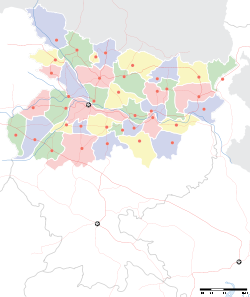
Dobhi

Dobhi
Dobhi
—  village  —
Dobhi
Location of Dobhi
in Bihar and India
Coordinates 24°32′N 84°55′E / 24.53°N 84.91°E / 24.53; 84.91Coordinates: 24°32′N 84°55′E / 24.53°N 84.91°E / 24.53; 84.91
Country India
State Bihar
District(s) Gaya
Time zone IST (UTC+05:30)

Dobhi is a town in Gaya district in the Indian state of Bihar.

Contents

Geography

Dobhi is located at 24°32′N 84°55′E / 24.53°N 84.91°E / 24.53; 84.91. It has an average elevation of 67 metres (220 ft).[1]

Transport

Dobhi is on NH 2 (Grand Trunk Road). It is also the junction point for NH 83, which connects to Bodh Gaya, 22 kilometres (14 mi), Gaya and Patna, 130 kilometres (81 mi), and also NH 99, which connects to Chatra and Chandwa in Jharkhand. Sherghati is 13 kilometres (8.1 mi) to the west and Barhi is to the east on NH 2. [2]

References

  1. ^ "Dobhi, India Page". Bihar. Falling Rain Genomics. http://www.fallingrain.com/world/IN/34/Dobhi.html. Retrieved 2009-03-10. 
  2. ^ "Dobhi". india9.com. http://www.india9.com/i9show/Dobhi-66847.htm. Retrieved 2009-03-10. 

See also


Wikimedia Foundation. 2010.

Игры ⚽ Поможем написать курсовую

Look at other dictionaries:

  • Indian Rebellion of 1857 — Sepoy Mutiny redirects here. For other uses, see Sepoy Mutiny (disambiguation). Indian Rebellion of 1857 A 1912 map of Northern India The Revolt of 1857–59 showing the centres of rebellion including the principal ones …   Wikipedia

  • National Highway 2 (India) — NH 2 redirects here. NH 2 may also refer to New Hampshire s 2nd congressional district …   Wikipedia

  • Jaunpur, Uttar Pradesh — Infobox Indian Jurisdiction native name = Jaunpur | type = city | latd = 25.73 | longd = 82.68 locator position = right | state name = Uttar Pradesh district = Jaunpur leader title = leader name = altitude = 82 population as of = 2001 population… …   Wikipedia

  • National Highway 99 (India) — 99 …   Wikipedia

  • National Highways in Bihar — Bihar has length of 3,537 km Nation highways.[1] List of National Highways in Bihar Main article: List of National Highways in India (by Highway Number) NH Route inside Bihar Complete Route Length in State (km) Total Length 2 Uttar Pradesh… …   Wikipedia

  • National Highway 83 (India) — 83 …   Wikipedia

  • Bodh Gaya —   city   …   Wikipedia

  • Nawada — This article is about the municipality in India. For its namesake district, see Nawada district. Nawada   town   …   Wikipedia

  • Nawada district — This article is about the district. For its eponymous headquarters, see Nawada. Nawada district नवादा जिला Location of …   Wikipedia

  • Arwal district — This article is about the district. For its eponymous headquarters, see Arwal. Arwal district अरवल ज़िला State Bihar,  India …   Wikipedia

Share the article and excerpts

Direct link
Do a right-click on the link above
and select “Copy Link”